BIM Conversion & Analysis Workshop: Story of the I-35W Bridge Collapse
•
7 j'aime•4,141 vues

Get tips on working with 3D and BIM data in this look at the 2007 Minneapolis I-35W bridge collapse.

Recommandé
Recommandé
Contenu connexe
Tendances
Tendances (20)
En vedette
En vedette (18)
Similaire à BIM Conversion & Analysis Workshop: Story of the I-35W Bridge Collapse
Similaire à BIM Conversion & Analysis Workshop: Story of the I-35W Bridge Collapse (20)
Plus de Safe Software
Plus de Safe Software (20)
Dernier
Dernier (20)
BIM Conversion & Analysis Workshop: Story of the I-35W Bridge Collapse
- 3. Participants Raj Banga, DBI Architects Dean Hintz, Safe Software Lutz Ross, Virtual City Systems Alex Karman, Revolutionary Machines
- 7. FME Capabilities Transform Data to Use and Share Convert spatial data between hundreds of formats Transform spatial data into the precise data model you need Integrate multiple different data types into a single data model Share spatial data with people where, when and how they need it
- 8. Translation FME supports reading from a wide array of data formats and types: •300+ formats, with more added each year •CAD, GIS, raster, database, web, non-spatial, 3D
- 9. Transformation Move data between formats and systems Restructure data models and schemas •Geometry •Attributes •Coordinate systems and projections Example •Derive new attribute values or construct geometry PointConnector transformer
- 10. Current FME 3D Formats Revit
- 11. •Adobe 3D PDF •LAS / LAZ •Autodesk 3ds •AutoCAD Civil 3D •AutoCAD DWG/DXF/RealDWG •Bentley Microstation •CityGML 2.0, ADEs •COLLADA •DirectX X File •Esri ArcGIS Layer •Esri Geodatabase •Free File Geodatabase API •NetCDF •Esri Shape •Google SketchUp, KML •IFC •LandXML •Oracle Spatial Object •Oracle Spatial Point Cloud •Point Cloud XYZ •Pointools POD •Presagis Openflight •Revit •VRML •Wavefront OBJ •XML / GML 3D Formats CAD VECTOR RASTER DATABASE BIM/3D WEB POINT CLOUD
- 12. FME Tools for Tackling 3D Format translation Database loading and extraction GML, XML and web service support Schema mapping Geometry model conversion (e.g. solid to mesh) Geometry transformation Geometry validation Complex geometry support, hierarchical Reprojection, geo-referencing, vertical datums
- 13. Turn This…
- 14. …Into This
- 15. Google Sketchup
- 16. IFC: Industry Foundation Classes
- 17. Point Clouds / LIDAR http://www.fmepedia.com/index.php/Category:Dmitris_Point_Cloud_Lab
- 18. Why extract info from BIM? Visualization
- 19. Why extract info from BIM? Views (Floor plans) Routing
- 20. Why extract info from BIM? Analysis
- 21. University of Washington Workflows Projects Data Updates Geometry Update Automated Sync Linked System For Administration, Operations, and Maintenance CAD/BIM GIS CMMS Life Safety Record Documents EH&S Space Inventory Security Room Scheduling FM Systems Misc. GIS Changes Misc. CAD/BIM Changes Aaron Cheuvront CAD/GIS Program Manager UW Capital Projects Office - Information Systems
- 22. HOK Scenarios. Greg Schleusner Director of BuildingSMART Innovation Christopher Zoog BuildingSMART team member Model checking Hierarchical DWG export Intelligent PDF export Enterprise wide sharing
- 23. Distribution: 3DPDF, KML, GeoDB, OBJ
- 26. CityGML: Motivation An increasing number of cities and companies are building virtual 3D city models Different application areas: E.g. Urban planning, disaster management, navigation, environmental simulations Graphical or geometric models are limited to visualisation purposes Growing need for Semantic Models to satisfy: thematic queries, analysis, spatial data mining Reusability -> costs reduction
- 27. CityGML: Motivation (C) by T.H. Kolbe
- 28. CityGML: What is it? CityGML is a data model and exchange format for virtual 3d city models Modeling of all relevant parts of the virtual city according to their semantics, geometry, topology and appearance GML 3 application schema (XML based)
- 31. CityGML | Characteristics Multi-Scale Modelling [Level of Detail] From landscape to interior model LOD 0 – Regional model LOD 1 – City model LOD 2 – City model with roof structure LOD 3 – Detailed architecture LOD 4 – Interior Model Source: slide from: Christian Dahmen, conterra
- 32. CityGML | Characteristics External References Refer to external data sources containing additional data Appearance (Textures) Application Domain Extensions (ADE) E.g. Noise, Energy, INSPIRE Generic city objects and attributes Source: slide from: Christian Dahmen, conterra
- 33. Thematic modules Building CityFurniture Relief Transportation Vegetation WaterBody Tunnel Bridge CityObjectGroup © KIT – Karlsruher Institute of Technology
- 34. Read and Write CityGML up to version 2.0 Support for any arbitrary ADE’s E.g. INSPIRE, Dutch IMGeo, Noise FME supports All thematic modules Level of Detail (LoD 0-4) Generic objects and attributes Non-spatial data / metadata Reprojection FME's support for CityGML
- 35. FME Support for CityGML
- 36. FME Support for CityGML
- 37. Reader Driven by CityGML Schema One FME Feature Type per CityGML class (object) Reading CityGML
- 38. Typical CityGML Workflows Data Inspection and Evaluation CityGML model generation Creating LODs 3D data generation from 2D •2.5D draping •3D extrusion Database loading BIM to GIS Export to distribution formats (PDF / KML)
- 39. Add CityGML specific attributes and geometry properties Format Attribute citygml_lod_name lodxSolid[1..4], lodxMultiSurface[2..4], lodxGeometry[0..5] Build relationship between features Example: 'Building' address 'Address' Use gml_id and gml_parent_id for relation Format Attribute citygml_feature_role CityGML Model entities by FME feature types Manually define or import CityGML entities Import entities from an existing CityGML dataset Writing CityGML: Basics
- 40. <CityModel> <cityObjectMember> <bldg:Building gml:id="UUID_13d7d225> ... <creationDate>2008-12-09</creationDate> <bldg:boundedBy> <bldg:WallSurface gml:id="UUID_50d7d286"> ... <bldg:opening> <bldg:Window gml:id="UUID_86e6b220"> ... </bldg:Window> </bldg:WallSurface> <bldg:RoofSurface gml:id="UUID_535118a1"> ... </bldg:RoofSurface> <bldg:GroundSurface gml:id="UUID_5350147b"> ... </bldg:GroundSurface> </bldg:Building> </cityObjectMember> </CityModel> Writing CityGML: Sample
- 41. IFC to CityGML Workspace Geometry transform, schema mapping and geo-referencing
- 42. IFC to CityGML Result
- 43. CityGML Writing Transformers filtering, id generation, configuring geometry model
- 44. Revit to CityGML: Leesburg Courthouse Square
- 45. Real World CityGML Models EU INSPIRE ADE Netherlands IMGeo 3D ADE, Geonovum Environmental Noise Directive Statewide LoD1 & LoD2 Buildings in Germany Sultanate of Bahrain, National 3D cadastre Singapore is evaluating CityGML as national 3D standard Further examples include Paris, Vienna, Brussels, Innsbruck, … 48
- 46. GeometryValidator for 3D •Checks for solids with inverted faces, dangling surfaces, unsealed solids, etc •Flag errors with meaningful attributes and geometric locations of the errors •Chain multiple validators to isolate problems of interest (e.g 2d before 3d) •Repair option for 3D surfaces and solids
- 49. Summary FME support for 3D & CityGML workflows: •Reading & writing CityGML and ADE’s •Translation to / from other 2D or 3D format •Transformation of schema and geometry •Validation of schema, geometry and semantics •Automation and enterprise services Publication of 3D data and analysis services
- 51. Alex
- 52. We live in a Physical World •We live in a physical world •We identify with physical objects •Engineered structures are the focal point and jumping off point for all of the information needed by all of the roles that interact with that structure •What is the value of this new paradigm?
- 53. How the New Paradigm Changes Things •Reduce Costs •Reduce Time •Do things we Couldn’t do Before •Make Information Accessible to More People •Empower Business Owners and Subject Matter Experts •Fewer licenses, less technical labor •Avoid coordinated schema changes and software releases •Real time updates, sensor integration, inferencing •Easily merge and match any data related to an engineered structure •Directly translate business concepts into IT concepts available on the Internet backbone
- 54. A Universal Index of the Physical World •By treating CityGML as a 3D index to external databases, rather than as data, we can associate at least a million times more data with any structure modeled in CityGML •By embedding RDF URIs in CityGML as semantic links to external semantic databases, we can create an agile, egalitarian, low-cost, and multidisciplinary uber-database, accessible to everyone over HTTP (no schemas, data models, release cycles, protocols, interfaces, etc.) •RDF URIs are unambiguous references to things – no more “is this field in this database the same thing as that field in that database?” issues •No more field formats, codelists, Entity Catalogs, Feature Classes •Data is actionable the instant it is discovered, without the intervention of specifications and release cycles •CityGML becomes a Universal Index of the Physical World Nutshell: Don’t insert your data, insert URIs to your data!
- 55. The Value Proposition Of the Universal Index •Engineering design tools like Revit will not have to become increasingly bloated to accommodate more and more “ancillary” data •The data can be managed and kept current by subject matter experts •Cooperation without coordination – merge and match information easily •M2M “spiders” and “crawlers” can construct a sophisticated business context around the data and generate unique data products
- 56. The Power of the Universal Index •The NTSB collected 34 DVDs and 5,400 pages of documents for this incident. •You would not want to embed hyperlinks in CityGML for all of the documents. •You would not want to cram all that ancillary data in an engineering design tool like Revit, either! •Instead, you want to link the bridge to the documents, not the documents to the bridge •This establishes a context. •This can scale exponentially.
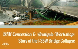
- 57. What We will Demonstrate On August 1, 2007, the I-35W bridge in Minneapolis collapsed into the Mississippi River. The NTSB collected over 5000 pages of documents and 34 DVDs of digital data on the accident. This makes the bridge an excellent example to demonstrate that using CityGML as an index and embedding URIs in it scales much better (to Big Data scale) than storing hyperlinks and data in the BIM model itself.
- 58. What We Did for the Workshop: the Original Bridge 1.We built a digital BIM model of the bridge in Revit off of the original 1965 blueprints. 2.We transformed it into CityGML in FME Desktop. 3.We ontologized a substantial portion of the available documentary evidence. 4.We added URIs for the bridge ad eight of its components to the CityGML model. 5.We prepared exercises that use the SPARQL query language to explore the data relationships 6.We demonstrated that using the CityGML model as an index scales better and builds a richer business context than inserting hyperlinks and data into the model.
- 59. What We Did for Workshop: the New Bridge •We also ontologized the Federal Highway Association’s Inspection Record for the replacement bridge (from an ASCII flat file into RDF). •The National Bridge Inventory contains a yearly record for each of 300,000 bridges in the US. •Each record contains 116 fields of data. •We prepared SPARQL exercises to demonstrate the Universal Index approach provides context around otherwise stove-piped data sources like ASCII flat files and spreadsheets.
- 60. Tools Used in the Workshop •Protégé – Visualize (and edit) ontologies •Jena ARQ – perform SPARQL queries •VirtualCityMap– Visualize CityGML and access embedded semantic links •FME Desktop – Convert BIM to CityGML •Revit – Visualize (and edit) bridge BIM •Installation instructions are on the Rev-Mac Blog
- 61. I-35 Bridge Workflow: Revit to linked CityGML 1.Bridge BIM created in Revit by DBI Architects 2.Revit Extension - FME Exporter - creates .rvz file 3.FME Workspace: Revit .rvz to CityGML conversion with embedded component uri’s 4.VirtualCitySystems imports CityGML into their 3D City Database 5.RevMac – uses linked data tools / rdf to analyze embedded component data
- 62. DBIA - Raj
- 63. DBI Architects, Inc. •Washington DC Metro Area •Commercial Interiors •Private Sector •Public Sector (Security and Intelligence Agencies) •Institutional Sectors •Architecture •Planning •Emphasizing Design Technology •Early Adopters of CAD and BIM Technology •90% of projects in Autodesk Revit Architecture •Integrating with BIM clients, partners, and vendors •Focused on future use of BIM technology for use in A/E/C/O
- 64. The Model Is ‘geometric representation of the original scanned construction document blueprints from 1965 All bridge ‘components’, (ie: concrete pilings, trusses, gusset plates, road surface, etc) were modeled utilizing Autodesk’s Revit Architecture platform. No structural calculations or algorithms were ‘re- engineered’ within this digital model. Intent for this exploration was not to digitally ‘re- construct’ each and every component, but to have a ‘geometric representation’ Building Information Model (BIM) to which we would illustrate how to externally link semantic data. Creating the Digital I35W Bridge
- 65. I-35 Bridge in Revit
- 66. Facts About the I35W Bridge Construction began in 1965 – completed in 1967 Bridge collapse occurred on Aug 1, 2007 Over 1900 feet long 14 spans – 11 ‘Approach’ Spans (5 South, 6 North) 3 Main Spans The 3 Main spans are “Deck-Truss” construction (Structural steel beams support the roadway deck) 9 of the North and South spans are “Multi-Girder Steel” (Concrete supported by steel I-beams) 2 of the North and South spans were simple Concrete slab Center span is one single 458-foot steel arch truss with two concrete support piers on the North and South River banks. All other spans were 266 feet in length and were connected to the approach spans by a 38-foot cantilever Each support pier had two load-bearing concrete pylons at either side capped with roller bearings. Concrete roadway deck was approx. 113 feet wide and approx. 115 feet above the river Failure Point – U10 Gusset Plate
- 68. FME workflows: BIM to CityGML Dean
- 69. I-35 Bridge Workflow: Revit to linked CityGML 1.Bridge BIM created in Revit by DBI Architects 2.Revit Extension - FME Exporter - creates .rvz file 3.FME Workspace: Revit .rvz to CityGML conversion with embedded component uri’s 4.VirtualCitySystems imports CityGML into their 3D City Database 5.RevMac – uses linked data tools / rdf to analyze embedded component data
- 70. Revit to CityGML Demo: FME Workspace Read Revit .rvz file (from Revit->addins->FME Exporter) Georeference / reproject Schema mapping (feature type, attributes) Set IDs to define object hierarchies Set CityGML LOD and Role (lod4MultiSurface) Add external references (uri’s) Remove rivets Write CityGML features
- 71. Revit to CityGML Workspace
- 72. I35 Bridge CityGML: Data Inspector
- 73. Faulty Gusset Plate with URIs
- 74. Virtual City Map Viewer
- 75. Virtual City Map Viewer
- 76. Conversion Challenges •BIM too complex for most GIS applications •Geo-referencing •File size – instanced geometries (rivets) •Schema mapping •which source feature types match citygml ones •find citygml feature types that are compatible across tools (VCS CityGML 1.0) •External reference insertion
- 77. Conversion Solutions •FME RVZ reader allows data view selection to limit complexity •Offset transformers to align data •FME enhancements •performance and stability improvements •64 bit FME improves scalability •Limit to CityGML 1.0 feature types for now •Use VolumeCalculator to find, remove rivets •Creation and insertion of external references
- 79. virtualcitySYSTEMS GmbH CityGML Experts •Consulting •Training •Software Solutions •Vice-chair of the OGC CityGML SWG FME Experts •3D data transformations (to and from CityGML) •FME training on CityGML/3D data
- 80. Why CityGML? Urban Information Modeling …is far more than the 3D visualization of reality Geometry and its visual appearance is only one aspect of a real-world entity Key issue: Semantic modelling However: 3D City models are still often seen as being identical with 3D graphics models e.g., KML/COLLADA, 3DS, 3D PDF, etc.
- 81. Exploring the I-35W Bridge Key ideas: •Database backend •Web-based interface •Link the bridge model to resources from the WWW •Distributing/Sharing the data
- 82. Solution
- 84. Alex Part II After VirtualCityMap Demo
- 85. It’s All About Context •OK, you hyperlinked a document to a CityGML architectural component. Great! •How do people understand your link in context? •File naming convention? •Annotation? •Metadata schema? •Thousand of elements, mostly null! Answer: Use URIs, not hyperlinks!
- 86. Similar Data Files, Minimal Context: Easy to forget origin, author
- 87. The Universal Index of the Physical World IS Big Data for Urban Life! Imagine billions of URIs in this picture, pointing to quintillions of triples!!!
- 88. CityGML as an Index of URIs Universal Index of the Physical World •Agility (effortless merging and matching) • Cooperation without Coordination •Anyone Can say Anything About Anything (“AAA”) •Polymorphism and “sets, not templates” •Reduced Costs •Text over HTTP: the Internet Backbone •Fewer (or no) software licenses •Fewer gatekeepers (DBAs, Enterprise Architects) •Disambiguation •URIs •No stove-piped documents •No more “Does X exist?” •No more “I found Y. What is it about?” Scalability (Big Data for 3D Urban Life)
- 89. Metcalfe’s Law Metcalfe's law states that the value of a telecommunications network is proportional to the square of the number of connected users of the system (n2).
- 90. The Wheat (Rice) and the Chessboard 18,446,744,073,709,551,615 grains (Mt Everest) The Wiseman asks as reward for his service to the Emperor to put one grain of rice in the first square on a chessboard And double the number of grains in each succeeding square Results in 2^63 grains!
- 91. Ray Kurzweil’s “Second Half of the Chessboard” Big Data Data URIs Database Attributes The Computer Is on the Network The Network Is the Computer CodeList Feature Classes
- 92. Linked Open Data Cloud 31 Billion Triples in 2011 (last time counted)
- 93. The Bridge in the Linked Open Data Cloud The bridge component URIs can semantically link to billions of triples!
- 94. Why Use a Linked Data Solution? The amount of data a software engineering design tool can hold (and how much you could learn to access through menu options)
- 95. Why Use a Linked Data Solution? The amount of data a linked data solution can hold (potentially a billion times more!)
- 96. Why Use a Linked Data Solution? The amount of data a linked data solution can hold (potentially a billion times more!) Benefits •Constantly Updated •Include/add comments •Add comments to comments (allow for discussion threads) •Attach correspondence, history, conversations
- 97. Linked Open Data Principles •Use URIs to denote things. •Use HTTP URIs so that these things can be referred to and looked up ("dereferenced") by people and user agents. •Provide useful information about the thing when its URI is dereferenced, leveraging standards such as RDF, SPARQL. •Include links to other related things (using their URIs) when publishing data on the Web.
- 98. LOD Principles in Action •DBPedia URI for Bridge •A Uniform Resource Identifier for the bridge •http://dbpedia.org/resource/I-35W_Mississippi_River_bridge •DBPedia URL for RDF data for the bridge •A static file containing RDF triples about the bridge •http://dbpedia.org/data/I-35W_Mississippi_River_bridge.n3 •Wikipedia URL for Bridge •A human-readable HTML document •http://en.wikipedia.org/wiki/I-35W_Mississippi_River_bridge •DBPedia Sparql Endpoint •Client must submit a SPARQL query •http://dbpedia.org/sparql?q=“SELECT…”
- 99. An engineered structure is at the center of a large network of people who interact with it, each with different roles, responsibilities, abilities, and data Contractors and Inspectors Architects and Engineers Building Owners/Facility Managers Tenants/Occupants/Users Engineered Structures Provide a Central Focal Point to Related Information
- 100. Software Tools and Data Sources Should Be Tied to Their Corresponding Engineered Structures A software design and management tool should also be at the focus of this large network Contractors and Inspectors Architects and Engineers Building Owners/Facility Managers Tenants/Occupants/Users
- 101. Why it can Scale Infinitely URI URI URI URI ONTOLOGY Subject Matter Experts Constantly updated and managed by SMEs To Linked Data Sets No Release Cycle CityGML as Index
- 102. ETL Database ERP CRM GIS BPM Doc Mgmt BI/ML Analytics Workflow Transportation E-Health E-Gov Utilities Homeland Security Energy Public Safety Maintenance/mgmt Earth Sciences URI URI URI URI URI Tourism •Wizard driven architecture •Connects role-specific clouds of information •All intersect in an engineered structure To-Be Architecture •Engineering design •Browser based •Server side and desktop software Tools Domains
- 103. Index (Card Catalog) Each entry in the card catalog points to a much larger collection of words (an entire book)
- 104. URI URI Objects let us link much more data! Alex Subject vs No “context” for “Donuts” Recipe Info Ingredients Nutritional Info Market Share Info Triples Were Born To Point to Other Things Across the Internet URI Predicate Literal Donuts Object Likes URI Alex Subject URI Predicate URI Donuts Object Likes Much larger “context” for “Donuts”!
- 105. SPARQL Commands Bring Internet Resources to Your Desktop DESCRIBE Returns triples SELECT Returns bound variables (as text, JSON or XML) ASK – perfect for alerts Returns true/false CONSTRUCT – perfect for sensors Returns a graph of your own design
- 106. List of Public Ontologies That Help Link Other Ontologies •VOID •describes links between data sets •SIOC (pronounced “shock”) •describes software projects •SourceForge, github, Maven, etc use it •FOAF •describes “friend of a friend” •Used on thousands of websites; drupal module too. •Dublin Core •describes documents and the people related to them •Author, publisher, contributor etc.
- 107. What Rev-Mac is Doing with CityGML and RDF •Create wizard driven architecture that automates the creation of URIs in 3D engineering software •Create wizard driven architecture that explores URIs, in 3D engineering software •Create wizard driven architecture that allows people to edit, manage and add semantic links in 3D engineering software
- 108. The Power of RDF Context: Google Hit List v. Google Rich Snippets Search “Lenses” Web pages have no RDF in them Google returns simple hit list Movie sites have RDF embedded in their web pages (ignored by your browser) Google returns awesome showtime chart! Search “Movies at Reston Town Center”
- 109. The Power of RDF: Note the “callout box” on the right
- 110. Exercise 07: Describe Bridge from DBPedia
- 111. Exercise 07 Return: Thousands of Triples! (This is just a snippet showing the Callout Box) Just the triples that make the “Callout Box” are shown. Triples in many languages!
- 112. NS: As-Is Software Lifecycle Not Agile, Release-Bound)
- 113. Polymorphism: What Else Could this Bridge Be? •Bridge •Structure •Construction Project •Disaster •Asset •Source of Noise Pollution •Job Creator •Infrastructure •Evacuation Route •Highway Segment •Historical Monument •Hazardous Area (Pedestrian-Free Zone) •EPA Site A Feature Class/Entity Catalog/Code List nightmare!!!!
- 114. Polymorphism: I am a… •Son •Husband •Employee •Owner •Director •Licensed Driver •Licensed Ham •All of these could be asserted on different sites •RDF was made for this situation. Object oriented programming and relational databases were not!
- 115. Polymorphism: "Cooperation Without Coordination" Classes --------- owl:NamedIndividual owl:Thing <http://dbpedia.org/ontology/ArchitecturalStructure> <http://umbel.org/umbel/rc/Bridge> <http://dbpedia.org/ontology/RouteOfTransportation> <http://umbel.org/umbel/rc/Building> <http://www.opengis.net/gml/_Feature> <http://schema.org/Place> <http://dbpedia.org/ontology/Place> <http://www.w3.org/2003/01/geo/wgs84_pos#SpatialThing> <http://dbpedia.org/ontology/Wikidata:Q532> <http://dbpedia.org/ontology/Bridge> <http://www.ontologydesignpatterns.org/ont/d0.owl#Location> <http://dbpedia.org/ontology/Infrastructure> DBPedia recognizes 14 classes for the original bridge Six are from other websites. No need to exchange schemas.
- 116. A Tale of Two Bridges •The Original Bridge Fell •Bridge •Collapse Event •Finite Element Analyses •Documentary Evidence •Force Summary Spreadsheet •The New Bridge Gets Inspected Annually •Bridge •Inspection Event •National Bridge Inventory Record •116 Observations
- 117. Has Design Element Design Element Field Report Bridge Bridge Component Truss Blueprint FEA FEA . . . Ontology: The Old Bridge Gusset Plate Design Element Analysis Element
- 118. Thing text MT Guide Nat’l Bridge Inventory Record Nat’l Bridge Inspection Record Has Build Date Civil Engineering Structure Bridge ? ? ?/? Observation Ontology: The New Bridge Belongs to Bridge Has Value
- 119. Protégé Class View (“Truss” Selected) Note that there are 7 Individual Trusses modeled (the purple diamonds)
- 120. Individuals View (“Collapse” Shown)
- 121. Individuals View (“Bridge_Original_9340” Shown)
- 122. FEA Force Summary Spreadsheet (We ontologized it) Become “AnalyticalElement” and “DesignElement” classes, hasFx etc Data Properties
- 123. Individuals View (AnalyticalElement Shown) “DesignElements” are very similar. We can summarize As-Built/Failed!!
- 124. Force Summary (Turn it back into a spreadsheet)
- 125. Return: Spreadsheet As-designed and as-failed Loads Compare these values to the original Excel spreadsheet But as RDF graph data it has context (bridge, author, date, FEA, Final Report, etc.)
- 126. National Bridge Inventory Website (ASCII files are available on this site)
- 127. NBI Encoding Guide (We ontologized it) The ontologized document is now part of a much larger context We can turn spreadsheets into RDF object graphs and vice- versa But only as an RDF object graph can the data become part of a larger context
- 128. Alex - Review •Our Team has Developed the answer to Integrating static objects with continuous updates from the web •CityGML is the standard of the future and we are at the forefront of building a virtual world that is live •Our world is complex – Rev-Mac can link it live •What’s Next – Transitioning live models to Augmented Reality ! •Join us on our web site www.rev-mac.com •http://www.rev- mac.com/bridge_workshop/index.html
- 130. Summary •CityGML - Ideal for 3D modeling and data exchange •FME – Ideal tool to support 3D & CityGML with conversion, transformation and automation •3D BIM data, once exported via CityGML, opens up a wide array of uses and applications •Transforming the I-35 Bridge from BIM to CityGML with embedded uri’s frees BIM for many more uses •CityGML as a universal index of the physical world •Don’t insert your data, insert URIs to your data •Linked models allow better management of complex infrastructure and its risks
- 135. Contacts Raj: RBanga@dbia.com Lutz: lross@virtualcitysystems.de Alex: alex.karman@rev-mac.com Dean: dean@safe.com
- 136. Links DBIA www.dbia.com Virtual City Systems www.virtualcitysystems.de Revolutionary Machines www.rev-mac.com Safe Software www.safe.com
- 137. Resources Virtual City Systems Demo http://hosting.virtualcitysystems.de/demos/interstate-35bridge/ FME Readers & Writers (CityGML Tutorial) http://docs.safe.com/fme/reader_writerPDF/citygml.pdf CityGML specifications http://opengeospatial.org/standards/citygml CityGML.org (Thomas Kolbe, etc) www.citygml.org/fileadmin/citygml/docs/CityGML_Tutorial_Kolbe_Internet.pdf Safe.com http://safe.com/solutions/for-data-types/3d/ FMEPedia http://fmepedia.safe.com/topic/3D