SlideShare une entreprise Scribd logo
1  sur  168
CONTENT


S. No. Topics                                  Faculty                Page No.

1.     Overview of Remote Sensing              Ms. Shefali Agarwal    1

2.     Terrain Analysis                        Ms. Shefali Agarwal    15

3.     Geographic Information System           Mr. P.L. N. Raju       27

4.     Fundamental Concepts of GPS             Mr. P. L. N. Raju      38

5.     Geo informatics for Natural             Dr. P.S. Roy           69

       Resources Management                    Dean, IIRS

6.     Applications in Agriculture and Soils   Dr. S.K. Saha          104

7.     Applications in Forest Management       Dr. S. P.S. Kushwaha   117

8.     Applications in Geosciences             Dr. P.K. Champtiray    128

9.     Applications in Human Settlement        Dr. B.S. Sokhi         139

       Studies and Management

10.    Applications in Marine Sciences         Dr. D. Mitra           143

11.    Applications in Water Resources         Dr. S.P. Aggarwal      154
1


                          OVERVIEW OF REMOTE SENSING


                                      Shefali Agrawal
                     Photogrammetry and Remote Sensing Division


1. Introduction
       In recent times earth observation from aerospace media has gained significant
importance due to ever increasing demand for most authentic, timely and uniform
information of earth surface features and processes involved. Due to rapid development
and changing life style, the impact on environment and its effect on surface processes
and features have under gone sea change. The impact of development on the
environment is significant as the rapidly growing population; urbanization and other
development efforts have exerted tremendous pressure on natural resources and have
caused their depletion and degradation. Biodiversity is declining at an unprecedented
rate - as much as a thousand times what it would be without the impact of human
activity. Half of the tropical rainforests have already been lost. Land degradation affects
as much as two thirds of the world's agricultural land. As a result, agricultural
productivity is declining sharply. The conservation measures are far from satisfactory
and as development processes and interventions still continue, natural resources will be
subjected to greater damage in the future. Hence there is an urgent need to look for
alternative strategies and approaches for better and more efficient management of
natural resources in order to ensure their sustainable use. This is further compounded
by the ever increasing occurrences of natural hazards. Therefore, there is a greater
demand for most authentic timely information on a suit of geophysical parameters and
environmental indicators. Towards this space provides a vantage point where a large
number of sensors have been deployed onboard satellites providing geo spatial
information needed to understand the Earth system as a whole.


1.1. Definition of Remote Sensing


       Remote sensing is the science of acquiring information about the Earth's surface
without actually being in contact with it. This is done by sensing and recording reflected

                Remote Sensing: An Overview for Decision Makers          IIRS/LN/DMC/2010
2


or emitted energy and processing, analyzing, and applying that information (Lillesand
and Kiefer, 2004).Remote sensing, also called earth observation, refers to obtaining
information about objects or areas at the Earth’s surface by using electromagnetic
radiation (light) without coming in physical contact with the object or area. The basic
process involved in remote sensing is the interaction of the electromagnetic radiation
with the Earth's surface and detection at some altitude above the ground. Remote
Sensing Systems have four basic components to measure and record data about an
area from a distance, Fig1. These components include:
   •   Emission of electromagnetic radiation (EMR)
   •   Transmission of energy from the source to the surface of the earth, as well as
       absorption and scattering
   •   Interaction of EMR with the earth's surface: reflection and emission
   •   Transmission of energy from the surface to the remote sensor
   •   Sensor data acquisition
   •   Data transmission, processing and analysis


                             Fig.1 Remote sensing process


   With respect to the type of energy resources, the RS technology is defined as
passive or active, Fig 2. Passive Remote Sensing makes use of sensors that detect the


               Remote Sensing: An Overview for Decision Makers           IIRS/LN/DMC/2010
3


   reflected or emitted electro-magnetic radiation from natural sources. Active remote
Sensing makes use of sensors that detect reflected responses from objects that are
irradiated by artificially generated energy sources, such as radar.


                          Fig.2. Passive and active remote sensing


With respect to Wavelength Regions, the RS technology is classified as:

   • Visible and reflective infrared RS operating at a range of 0.4μm to 2.5μm.


   • Thermal infrared remote sensing operating at a range of 3μm to14μm.


   • Microwave remote sensing operating at a range of 1mm to1m.


                Remote Sensing: An Overview for Decision Makers       IIRS/LN/DMC/2010
4


                                     ‘Optical range’

              Cosmic Gamma X-                                                   Radio    Electric power
                                     U-V            Infrared   Micro-waves TV
               rays   rays Rays


                                           Visible spectrum


                Ultraviolet         Blue             Green             Red               Infrared (IR)


               0.3μ m         0.4               0.5μ m           0.6            0.7μ m     10.0      15.0

                300nm                          500nm                            700nm

                                                Wavelength


                              Fig.3. Electromagnetic spectrum


 1.2 Interaction of EMR with the Earth's Surface


       Radiation from the sun, when incident upon the earth's surface, is either reflected
by the surface, transmitted into the surface or absorbed and emitted by the surface. The
EMR, on interaction, experiences a number of changes in magnitude, direction,
wavelength, polarization and phase. These changes are detected by the remote sensor
and enable the interpreter to obtain useful information about the object of interest. The
remotely sensed data contain both spatial information (size, shape and orientation) and
spectral information (tone, color and spectral signature).


       In the visible and reflective Infrared remote sensing region, the radiation sensed
by the sensor is that due to the sun, reflected by the earth's surface. A graph of the
spectral reflectance of an object as a function of wavelength is called a spectral
reflectance curve. Figure shows the typical spectral reflectance curves for three basic
types of earth feature vegetation, soil, and water in the visible and reflective Infrared
region Fig.4.The band corresponding to the atmospheric window between 8 μm and 14
μm is known as the thermal infrared band. The energy available in this band for remote


                Remote Sensing: An Overview for Decision Makers                              IIRS/LN/DMC/2010
5


sensing is due to thermal emission from the earth's surface. Both reflection and self-
emission are important in the intermediate band from 3 μm to 5.5 μm.
      In the microwave region of the spectrum, the sensor is radar, which is an active
sensor, as it provides its own source of EMR. The EMR produced by the radar is
transmitted to the earth's surface and is reflected (back scattered) from the surface to
be recorded by the radar system again. The microwave region can also be monitored
with passive sensors, called microwave radiometers, which record the radiation emitted
by the terrain in the microwave region.


      Fig. 4. Typical spectral reflectance curves for vegetation, soil and water.


      In the microwave region of the spectrum, the sensor is radar, which is an active
sensor, as it provides its own source of EMR. The EMR produced by the radar is
transmitted to the earth's surface and is reflected (back scattered) from the surface to
be recorded by the radar system again. The microwave region can also be monitored
with passive sensors, called microwave radiometers, which record the radiation emitted
by the terrain in the microwave region.


 1.3 Platforms and Sensors


      In order to enable sensors to collect and record energy reflected or emitted from
a target or surface, they must reside on a stable platform away from the target or
surface being observed. As space provides one of the most vantage points for earth


               Remote Sensing: An Overview for Decision Makers           IIRS/LN/DMC/2010
6


observation, two prominent orbits are considered for Earth observation: the geo-
stationary orbit and the polar orbit. The geo-stationary orbit is such a position that it
keeps pace with the rotation of the Earth. These platforms are covering the same place
and give continuous near hemispheric coverage over the same area day and night.
These are mainly used for communication and meteorological applications. This geo-
stationary orbit is located at an altitude of 36,000 km above the equator Fig 5.


                             Fig. 5 Geostationary and near polar orbits


         The second important remote sensing orbit is the polar orbit. Satellites in a polar
orbit cycle the Earth from North Pole to South Pole. The polar orbits have an inclination
of approximately 99 degrees with the equator to maintain a sun synchronous overpass
i.e. the satellite passes over all places on earth having the same latitude at the same
local time. This ensures similar illumination conditions when acquiring images over a
particular area over a series of days. The altitude of the polar orbits varies from 600 to
900 km, approximately.


1.4. Resolutions


         In general resolution is defined as the ability of an entire remote-sensing system,
including lens antennae, display, exposure, processing, and other factors, to render a
sharply defined image. It depends on large number of factors that can be grouped
under:


                 Remote Sensing: An Overview for Decision Makers           IIRS/LN/DMC/2010
7


a. Spectral resolution: The spectral band in which the data is collected.

b. Radiometric resolution: It is the capability of the sensor to differentiate two objects
based on the reflectance / emittance differences.

c. Spatial resolution: It is the capability of the sensor to discriminate the smallest
object on the ground. Higher the spatial resolution smaller the object that can be
identified Spatial resolutions vary from few kilometers to half a meter.

d. Temporal resolution: It is the capability to view the same target, under similar
conditions at regular intervals.

       Today a large number of earth observation satellites provide imagery that can be
used in various applications.

2. Indian Remote Sensing Satellites


       India is one of the major providers of the earth observation data in the world in a
variety of spatial, spectral and temporal resolutions. India has launched several
satellites including earlier generation IRS 1A, IRS 1B, IRS 1C, IRS 1D, IRS P2,IRS P3,
IRS P4 and latest P6 and Cartosat series for different applications, the details of these
are listed in Table 1.


Table 1: Indian Earth Observation Satellites.
                                                       Spectral                   Swath
 Satellite                                    No. of                 Resolution           Revisit
              Launch     Sensors    Types              Range                      Width
  Name                                        Bands                     (m)               (days)
                                                            (µ)                   (km)

             March
Cartosat-1                         PAN          1                      2.5 m      25
             2005

                                                       0.52 - 0.59
             17th
                                                       0.62 - 0.68
IRS-P6       October     LISS -III MSl          4                       23        140     24
                                                       0.77 - 0.86
             2003
                                                       1.55 - 1.70


                Remote Sensing: An Overview for Decision Makers                IIRS/LN/DMC/2010
8


                                                    0.52 - 0.59
                                                    0.62 - 0.68
                      AWiFS       MSl         4                     56       740
                                                    0.77 - 0.86
                                                    1.55 - 1.70

                                                    0.52 - 0.59
                                                    0.62 - 0.68
                      LISS -IV MS             3                     5.8      23.9   5
                                                    0.77 - 0.86


                      LISS -IV PAN            1     0.62 - 0.68     5.8      70     5

                      OCM         MS          8     0.4 - 0.885   360 m      1420
IRS-P4    May 26,
                                                    6.6,10.65,    120, 80,          2
(Oceansat) 1999       MSMR        RADAR       4                              1360
                                                    18, 21 GHz 40 and 40

                                                    0.62-0.68
                                                    (red)
                        WiFS      MS          2                     189      774    5
                                                    0.77-0.86
                                                    (NIR)

                                                    0.52-0.59
                                                    (green)
          September
IRS-1D                                              0.62-0.68
            - 1997                            3                     23        142
                                                    (red)
                       LISS-III     MS
                                                    0.77-0.86                       24-25
                                                    (NIR)

                                                     1.55-1.70
                                              1                     70        148
                                                      (SWIR)

                        PAN        PAN        1     0.50-0.75        6        70

                                                    0.62-0.68
IRS-1C       1995
                                                    (red)
                        WiFS        MS        2                     189       810 5
                                                    0.77-0.86
                                                    (NIR)


              Remote Sensing: An Overview for Decision Makers             IIRS/LN/DMC/2010
9


                                                     0.52-0.59
                                                     (green)

                                                     0.62-0.68
                                               3                  23.6       142
                                                     (red)
                        LISS-III     MS
                                                     0.77-0.86                     24-25
                                                     (NIR)

                                                      1.55-1.70
                                               1                  70.8       148
                                                       (SWIR)

                         PAN        PAN        1      0.50-0.75    5.8        70

                                                     450-520

                                                     0.52-0.59
                        LISS-I       MS        4     0.62-0.68    72.5       148
IRS-1B        1991                                   0.77-0.86                     22

                                                     (NIR)

                                                     (same as
                        LISS-II      MS        4                  36.25       74
                                                     LISS I)

                                                     Same as
                        LISS-I       MS        4                  72.5       148
                                                     above
IRS-1A        1988                                                                 22
                                                      Same as
                        LISS-II      MS        4                  36.25       74
                                                     above


3. Global Satellites
      Global remote sensing satellites include Landsat, SPOT, ASTER, MODIS, MOS,
JERS, ESR, Radarsat, IKONOS, QuickBird etc (Table 2):


               Remote Sensing: An Overview for Decision Makers            IIRS/LN/DMC/2010
10


   Table 2: Earth Observation satellites from other countries


                                                              Spectral                  Swath
 Satellite                                         No. of                 Resolution            Revisit
              Launch      Sensors        Types                 Range                    Width
  Name                                           Channels                    (m)                (days)
                                                                    (µ)                 (km)

                                                            0.43-0.47
                                                            (blue)
                                                            0.61-
                                                                                        600 x
SPOT -5      May 2002        VMI          MS         4      0.68(red)       1000                 1
                                                                                        120
                                                            0.78-0.89(
                                                            NIR) 1.58-
                                                            1.75(SWIR)

                                                            0.5-0.59
                                                            (green)
                            HRS                             0.61-0.68        10
                                                            (red)            10
                                          MS         4                                    60     26
                                                            0.79-0.89        10
                            HRG                             (NIR)                  20
                                                            1.58-1.75
                                                            (SWIR)

                                                                            5 m,
                                                                          combined
                                                                              to
                                          PAN        1      0.61-0.68                    60
                                                                          generate a
                                                                          2.5-metre
                                                                           product.


                  Remote Sensing: An Overview for Decision Makers             IIRS/LN/DMC/2010
11


                                                                                 10 m
                                                                               (resampled
                                                         1      0.61-0.68       at every     60
                                            PAN
                                                                               5m along
                                                                                 track)

                                                                blue (0.45-
                                                         4                       2.5 m      17 km
                                                                0.52)

                                                                green
                                                                (0.52-0.6)
                                            MS
QuickBird- Oct. 18,                                             red (0.63-
2          2001                                                 0.69)

                                                                NIR.76-
                                                                0.89)

                                            PAN          1      0.45-0.9        0.61 m

           Dec. 5,                                                                          12.5
EROS 1                                      PAN          1      0.5-0.9          1.8 m                1-4
           2000                                                                             km

Terra                                                           VNIR -
           Dec. 18,
(EOS AM-                                                 3      stereo (0.5-     15 m                 16
           1999
1)                                                              0.9)
                          ASTER             MS                                              60 km
                                                                SWIR (1.6-
                                                         6                       30 m
                                                                2.5)

                                                         5      TIR (8-12)       90 m

                                                                SWIR, TIR,
                          CERES             MS           3                       20 km
                                                                Total

                                                                                            360
                          MISR              MS           4                     250-275 m
                                                                                            km

                          MODIS                          2      0.4-14.4         250 m      2330

                                                         5                       500 m      km


                      Remote Sensing: An Overview for Decision Makers              IIRS/LN/DMC/2010
12


                                                   29                 1000 m

                                                                               640
                      MOPITT            MS         3      2.3 (CH4)   22 km
                                                                               km

                                                          0.45-0.52
                                                          (blue)

                                                          0.52-0.60
                                                          (green)
IKONOS- September                       MS         4
                      IKONOS                              0.63-0.69                      11
2        24, 1999
                                                          (red)

                                                          0.76-0.90
                                                          (NIR)

                                        PAN        1                   1M

         Landsat7                                                              16
TM                    As Landsat 4-5 30x30        185                 705 km
         15/04/1999                                                            days

                      Band 6: 10,40 -
                                        60×60
                      12,50

                      Panchromatic:
                                        15×15
                      0,50 - 0,90

NOAA-K   May - 1998      AVHRR           MS        5                   1100

                                                          0.5-0.59
                              VMI       MS         4                  1000
                                                          (green)

                                                          0.61-0.68
                                                          (red)
         March 24,                                                                       26
SPOT-4                                                    0.79-0.89
            1998                        MS         4                   20      60
                           HRV                            (NIR)

                                                          1.58-1.75
                                                          (SWIR)

                                        PAN        1      0.61-0.68    10      60


                Remote Sensing: An Overview for Decision Makers         IIRS/LN/DMC/2010
13


4. Image Analysis and Interpretation


       In order to take advantage of and make good use of remote sensing data, we
must be able to extract meaningful information from the imagery. Interpretation and
analysis of remote sensing imagery involves the identification and/or measurement of
various targets in an image in order to extract useful information about them. Much
interpretation and identification of targets in remote sensing imagery is performed
manually or visually by a human interpreter. It is also possible to apply digital
techniques for image analysis and information extraction.


9. Comparison of RS to Traditional Observations


       RS data, with its ability for a synoptic view, repetitive coverage, observations at
different resolutions, provides a better alternative for natural resources management,
environmental monitoring and disaster management as compared to traditional
methods. It provides images of target areas in a fast and cost-efficient manner. While
air photos and fieldwork remain critical sources of information, the cost and time to carry
out these methods often make them unviable and the human ability of observation is
subjective and individual dependant, thereby making it even more unviable.              RS
instrumentation makes it possible to observe the environment with EM radiation outside
the visible part of the EM spectrum; the invisible becomes visible. RS is flexible in that
there is a variety of RS observation techniques and a diversity of digital image
processing algorithms for extracting information about the earth's surface. The data can
be easily integrated into a Geographical Information System thus making it even more
effective in terms of solution offering.


6. Future Prospects
       In near future large number of new satellites will be launched by India and other
countries with capabilities of providing high spatial, spectral and radiometric resolution
data for variety of applications like water security, disaster management, natural
resource management, food security, infrastructure development           etc. The use of
geosynchronous orbit for providing high spatial resolution data will be a major break-

                Remote Sensing: An Overview for Decision Makers           IIRS/LN/DMC/2010
14


through to receive bio-geophysical parameters in real time basis. Remote sensing
coupled with geographical information systems where the data can be integrated with
other information, will provide geo-spatial information that is critical for decision making
related to natural resource utilization, environmental monitoring and disaster
management.


References

Lillesand T.M. and Kiefer R. 2004: Remote Sensing and Image Interpretation (Third
       Edition). John Wiley, New York.


Web Links
http://www.ccrs.nrcan.gc.ca/ccrs/learn/tutorials/fundam/chapter1/chapter1_2
www.planetary.brown.edu/arc/sensor.html
http://www.ersc.edu/resources/EOSC.html
www.isro.org
www.spaceimage.com
www.eospso.gfc.nasa.gov
www.landsat.org
www.spotimage.fr/home
www.space.gc.ca
www.esa.int/export/esasa/ESADTOMBAMC_earth_O.html


                Remote Sensing: An Overview for Decision Makers            IIRS/LN/DMC/2010
15


                                   TERRAIN ANALYSIS


                                       Shefali Agrawal
                     Photogrammetry and Remote Sensing Division


1. Introduction


       Terrain components play an important role in natural resource survey,
environmental monitoring and natural hazards survey and analysis. Terrain features are
the most common features that can be observed from EO systems. Most importantly the
3-D attribute/nature of the terrain can also be mapped and monitored using present
generation of EO systems using stereo viewing capability of Cartosat-1, SPOT ALOS
Prism etc. and InSAR (Interferometric SAR) capability of Envisat and Radarsat. Terrain
features such as elevation, slope, aspect, and curvature influence most of the surface
process including soil erosion, slope failures and vegetation composition. One of the
most important attributes of terrain, topography influences atmospheric, hydrologic and
ecologic processes, such as, microclimate, local wind circulations and precipitation-
runoff processes. Soil formation is also a function of relief, slope and geomorphology.
Topographical features such as drainage basins, stream networks and channels, peaks
and pits, drainage divides (ridges) and valleys play an important role in hydrological
modeling related to flooding, locating areas contributing pollutants to a stream,
estimating the effects of altering the landscape etc. Relief information is also required
for removal of terrain distortions in aerial and satellite images and for creation of
orthorectified image maps. Terrain visualization has also an important place in military
and civil engineering operations. Based on the above application requirements and EO
opportunities, a lot of emphasis is given on extraction of terrain features from using
optical, radar, and Lidar data sets.


2. Digital Elevation Model (DEM)
       The most important aspect of the terrain is relief that can be represented as a


                Remote Sensing: An Overview for Decision Makers          IIRS/LN/DMC/2010
16


continuous surface in the form of a Digital Elevation Model (DEM). In GIS, DEM is used
to refer specifically to a regular grid of spot heights. It is the simplest and most common
form of digital representation of topography. The term Digital Terrain Model (DTM) may
actually be a more generic term for any digital representation of a topographic surface.
DEM, can be generated from the following basic relief information.

a) Contour lines: Usually elevations on a topographic map are represented as a group
of contour lines with a discrete and constant contour interval.

b) Grid data: For convenience of computer processing, a set of grid data with elevation
are acquired from contour maps, aerial photographs or stereo satellite image data.
Terrain data other than the grid data are interpolated from the surrounding grid data.

c) Random point data: Terrain features are sometimes represented by a group of
randomly located terrain data with three-dimensional coordinates. For computer
processing, random point data are converted to triangulated irregular network (TIN). TIN
has the advantage of easy control of point density according to the terrain feature,
though it has the disadvantage of being time consuming in the random search for the
terrain point.

d) Surface function: Terrain surface can be expressed mathematically as a surface
function, for example, a Spline function

3. Elevation Data Sources


       Elevation data can be obtained from the following sources
                 •       Survey data: including ground-based leveling and satellite-based
                         GPS data;
                 •       Remotely sensed data: including radar altimeter data, laser altimeter
                         data, optical and SAR stereoscopic image pairs, complex
                         interferometric SAR data, and shade information in single images;
                         and


                     Remote Sensing: An Overview for Decision Makers         IIRS/LN/DMC/2010
17


             •       Cartographic data: including contours, spot height points and
                     surface structural lines digitized from paper topographical map
                     sheets.


      Each data source has its own inherent strengths and limitations in terms of the
availability, accuracy, sampling density and pattern, and the ground coverage.


4. Elevation Data Acquisition Techniques


      At present a number of techniques are available for acquiring digital elevation
data. The ground survey and aerial photogrammetry represent the traditional elevation
extraction and measurement techniques. Contour-based topographical maps have long
been the primary storage media for terrain information throughout the world. GPS,
satellite image based stereoscopic technique, SAR interferometry, radar altimetry, and
laser altimetry are relatively new techniques for digital elevation acquisition. The advent
of new data capture technologies has increased the acquisition speed of elevation data,
improved the position and height measurements, extended their ground coverage, and
reduced the cost. Ground survey and satellite-based GPS technology tend to generate
very accurate positional and height measurements. Since both ground survey and GPS
techniques require physical visit of ground sampling points, the resulting measurements
are usually sparse. Often, they are utilized as GCPs (Ground Control Points) for
extracting more dense elevation data from stereo photogrammetric and InSAR
techniques or used as checking points for the DEM accuracy assessment.


5. Digitizing Topographic Maps


      Due to the relatively low cost and the widest availability, the digitization of
topographical maps represents the practical method for gathering digital elevation data
for a large area, particularly for national and continental scale projects. Cartographic
data are the second hand topographical information source, in the sense that they are
originally derived from direct height measurements of some kind. The information


                 Remote Sensing: An Overview for Decision Makers          IIRS/LN/DMC/2010
18


content of a topographical map depends on not only the quality of original source data
but also map scale and contour interval. In addition to contours and spot heights,
topographical maps may also contain, implicitly or explicitly, many important terrain
features such as surface break lines, ridges and drainage lines.


6. Photogrammetry-Based Stereo Technique


      The photogrammetry-based stereo technique derives the digital elevation data
based on parallax differences between a stereo image pair. The principle is simple; first,
two images are acquired of the same area with slightly different viewing perspectives
(stereo-overlap). These images are then aligned and geometrically matched so that a
mathematical (triangulation) model can be obtained. The analyst then has the
opportunity to view the modeled stereo pair in 3D to manually extract the terrain
information or use automated stereo correlation tools to extract a new DTM. The
automated process is typically used when the surface landscape needs to be extracted.
“Above-the-landscape” features (e.g., buildings) are typically derived manually (using
stereo extraction tools) and then “placed” on the DTM. The accuracy of the elevation
data derived from stereo technique is often influenced by mismatch of conjugate image
pixels, and errors of the sensor position and attitude. The current and future high-
resolution earth observation satellites (table 1) having a spatial resolution of 1m & less
and stereo capabilities will go a long way in the field of mapping in terms of cost, time
and accuracy.


Table 1: High resolution sensors


  Sensor                        Launch Date                  Resolution

  IRS-1C                        28-DEC-95                    Panchromatic: 5.8 m
  IRS-1D                        29-SEP-97                    Panchromatic: 5.8 m
  IKONOS                        24-SEP-1999                  Panchromatic: 1 m
                                                             Multispectral: 4 m


                Remote Sensing: An Overview for Decision Makers             IIRS/LN/DMC/2010
19


QuickBird                     18 October 2001              Panchromatic: .61 m
                                                           Multispectral: 2.44 m
EROS A1                       05-DEC-2000                  1.8m
CBERS 3                       2003                         Panchromatic: 5 m
EROS B1                       2003                         Panchromatic: .81 m
EROS B2                       2003                          Panchromatic: .81 m
                                                           Multispectral: 3.3 m
SPOT- 5                       1985                         Panchromatic: 2.5m from 2 x
                                                           5m scenes
                                                           Panchromatic: 5m (nadir)
Terra-ASTER                   December 1999                Multispectral (B1-B3) 15m

Cartosat-1                    May 2005                     (Panchromatic): 2.5 m
ALOS - PRISM                  January 2006                 Panchromatic: 2.5 m
WorldView 1                   September 2007               Panchromatic: 0.55 m
GeoEye-1                       August 2008                 Panchromatic – 0.41m
                                                           Multispectral : 1.65m


             Fig. 1. Photogrammetric technique (www.univcalagary)


              Remote Sensing: An Overview for Decision Makers             IIRS/LN/DMC/2010
20


7. Synthetic Aperture Radar (SAR) Interferometry


                                                Incidence                          Revisit
              Year of Ban        Polarizatio                     Swath   Resolut
SAR sensor                                      angle                              (days)
              launch     d       n                               (km)    ion (m)
                                                (deg.)


      The interferometric SAR (InSAR) technique has emerged as a precise approach
to the extraction of high-resolution elevation data and measurement of very small
surface motion (displacement); InSAR technique is based on the phase information
derived from the complex radar images. SAR interferometry combines complex radar
signals (images) recorded by the antenna at slightly different locations to measure the
phase differences between the complex radar images. Relating two complex SAR
images of the same scene acquired at two orbital locations forms an interferogram. As
the radar signal transmitted by the SAR sensor is coherent, the complex SAR image
possesses both phase and magnitude (quantities) information. The constructive and
destructive interference of coherent SAR images respectively recorded at slightly
different locations produce an interferogram with a two-dimensional fringe pattern,
which can be unwrapped into the absolute measurement of elevation.


            Fig. 2. Principle of SAR interferrometry (www.aerosensing.com)


               Remote Sensing: An Overview for Decision Makers             IIRS/LN/DMC/2010
21


ERS-1          1991       C       VV             23               100      30          35
JERS-1         1992       L       HH             35               75       18          44
ERS-2          1995       C       VV             23               100      30          35

Radarsat-1     1995       C       HH             10 to 50         40-500   8-100       24

SRTM           2000       X, C    VV             Variable         30-350   20-30

                                  HH/HV,                          100-     30-
Envisat-1      2002       C                      14 to 45                              35
                                  VV/VH                           400      1000
                                  VV,     HH,
PALSAR         2004       L       HH/HV,         18 to 55         70       10-100      44
                                  VV/VH
TerraSAR-X     2006       X       Quad-pol       10 to 100        15-60    2-16        11
Radarsat-2     2008       C       Quad-pol      10 to 50          10-500   8-100       24
                                                 20   to    49
                                                 (qualified)
                                                 10 to 20
RISAT          2008       C       Quad-pol                        10-240   3 - 50      13
                                                 and 49-54
                                                 (unqualifie
                                                 d)


Table 2: SAR satellites and sensors


8. Radar Altimetry
       Spaceborne radar altimeters have been deployed on board of Geosat, Seasat
and ERS-1 platforms for acquiring surface height measurements. A radar altimeter is a
nadir-pointing active microwave sensor designed to measure the surface height over
ocean and ice surfaces. The radar altimeter transmits a short duration Ku-band pulse
vertically downwards, and then tracks the returned radar pulse. The information of the
shape and timing of the returned signal is utilized to estimate the surface height.


                Remote Sensing: An Overview for Decision Makers                 IIRS/LN/DMC/2010
22


       Radar altimeters can provide accurate elevation measurements regardless of
weather condition over ocean and relatively flat and low-slope ground surface, but are
prone to errors over highly sloped and rugged lands due to the relatively large footprint.


9. Laser Altimetry


       A laser altimeter can provide height measurements of submeter level accuracy
with the aid of GPS and Inertial Navigation System (INS) in determining the position and
attitude of aircraft or spacecraft, but the data collection is usually time consuming due to
its narrow ground swath. Laser altimeter data may deteriorate in the condition of bad
weather, such as clouds and precipitation, it generally provides much more accurate
measurements than the radar altimeter due to the small footprint of the laser beam.


               Fig. 3. Principle of laser scanning (www.terraimaging.com)


10. Derivation of Surface Parameter


10.1 Elevation


       If the point of interest is exactly at a point in the raster, the elevation can be taken
directly from the database If the point of interest is between nodes of DEM grid, we
need to interpolate from neighboring grid points, e.g. bilinear, cubic, or fit a plane to the
nearby raster points.


                 Remote Sensing: An Overview for Decision Makers             IIRS/LN/DMC/2010
23


10.2 Slope


      Measure the surface steepness; Slope is rise over reach (rise/reach), where rise
is the change in elevation, and reach is the horizontal distance. It is expressed as:


             a ratio,
             a simple fraction,
             a percent,
             an angle in degrees.


10.3 Aspect (azimuth orientation)


      Aspect is azimuthal direction of maximum surface slope with reference to true
north. Aspect calculation is very sensitive to elevation errors, especially when the
surface slope is small. Without a slope, there is no topographic aspect. The aspect at
each location determines the direction of water flow over the terrain surface.


10.4 Surface Curvature (convergence/ divergence)


      The surface curvature is the second derivative of the surface (i.e., the slope of
the slope); the curvature of a surface can be calculated on a cell-by-cell basis. For each
cell, a fourth-order polynomial of the form is fit to a surface composed of a 3x3 window.


10.5 Profile Curvature
      The curvature of surface in the direction of slope is referred to as the profile
curvature. Profile curvature indicates where the surface is concave or convex, resulting
acceleration or deacceleration of flow. Where acceleration of flow occurs, the stream
gains energy and its ability to transport particles increases. Therefore, areas of convex
profile curvature indicate areas of erosion. Conversely, in areas of concave profile
curvature, the flow rate decreases, the stream loses energy, and deposition occurs.


                Remote Sensing: An Overview for Decision Makers           IIRS/LN/DMC/2010
24


10.6 Planform Curvature


       The curvature of a surface perpendicular to the direction of slope is referred to as
the planform curvature. Planform curvature indicates where the surface is concave or
convex, resulting in convergence or divergence of flow respectively; Convergent flow
indicates a concentration of runoff and would indicate a valley. Alternatively, divergent
flow would indicate a ridge.


10.7 Cut and Fill Calculation


       Estimation of the volume of material related to cutting and filling. By subtracting
the upper (top) surface height values from the lower surface height, a variable thickness
(depth) value can be obtained. The thickness values over the entire area can be
integrated to obtain the volume. Engineers need to establish road or railroad routes and
gradients that minimize the movement of earth. It is generally most economical to
balance the amount of material removed from the high areas (cut) with the amount of
material required to fill low areas (fill). Also used in Reservoir capacity estimation, ice
volume, etc.

11. Viewshed Analysis
       A viewshed is the region that is visible from a given vantage point in the terrain. It
assembles all the areas where the line of sight is rising as the rays move outwards. The
yes/no values can be summed to give a cumulative sense of how many times a place is
seen. Inter-visibility (what can be seen from where) can be computed based on a set of
rays radiating outwards from a vantage point. In a complex 3D situation, there are many
effects to calculate, but on a surface the surface can only obstruct a view by rising
above the line of sight. Applications of viewshed analysis include GPS signal
availability, scenic beauty evaluation, sitting television, radio, and cellular telephone
transmitter and receiver towers, locating towers for observing forest fires or enemy
movement.


                Remote Sensing: An Overview for Decision Makers            IIRS/LN/DMC/2010
25


12. Watershed Analysis


       The shape of a terrain determines the movement of water across the terrain
surface; Water will flow from higher locations downwards. A raster DEM contains
sufficient information to determine pattern and characteristics of a drainage basin, such
as, the upstream area contributing to a specific location and the downstream path water
would follow, the boundary of catchment area, flow line, ridges, the hierarchical stream
system, etc. The topology of terrain surface (skeleton of surface): peaks, pits, ridges,
courses (valleys), hills and dales, etc. The area upon which water falls, and the network
through which it travels to an outlet is referred to as a drainage system. The flow of
water through a drainage system is only a subset of the hydrologic cycle, which also
includes precipitation, evaporation, and groundwater; Watersheds tend to function
ecologically as single, uniform regions. Ecologists, hydrologists, engineers, pollution
and flood control experts need to be able to define these areas precisely.

13. Dem Visualization

       There are number of techniques to enhance and display DEM data. Shaded relief
is also one of the techniques, which is considered to be one of the most effective
techniques for representing topography.

13.1 Shading


The gradation from dark to light in a single color according to specific principals for the
purpose of creating a three dimensional effect is called shading. In contrast to the metric
accuracy of contour lines, hill shading is primarily used for its visual effects. Slope
shading operates on the principal that the steeper the slope - the darker the shade.
Oblique shading or hill shading is based upon the effect of an oblique light source on a
terrain surface.


                   Remote Sensing: An Overview for Decision Makers        IIRS/LN/DMC/2010
26


13.2 Slope Shading


Slope shading, operates basically on the principal of the steeper - the darker.

13.3 Hill Shading

      Hill shading is also known as a shaded relief or simply shading, it attempts to
simulate how the terrain looks with the interaction between sunlight and surface
features. It Helps viewers recognize the shape of landform features on a map.

14. Conclusions


      Terrain analysis typically encompasses numerical methods of describing
landscape attributes such as terrain roughness, vegetation, urban features, 3D models
etc. To fully model the continuous terrain surface, a large number of points are required
and DEM and TIN are two commonly used models of representing the continuous
topographic surface in digital form with a finite number of sample points. Most of the
commercial GIS systems provide both raster DEM and TIN model that can be used in
spatial analysis and surface modeling. However, it is important to note that the most
critical aspect of any terrain analysis is the accuracy of the terrain model it uses or how
close the data model either DEM/TIN represents the actual surface with all attributes.


Web Links


www.isprs.org
www.terraimaging.com
www.aerosensing.com


                Remote Sensing: An Overview for Decision Makers           IIRS/LN/DMC/2010
27


                      GEOGRAPHIC INFORMATION SYSTEM


                                      P.L.N. Raju
                                Geoinformatics Division


1. Significance of GIS in the Present Day Scenario


       Geographic Information System plays an important role in creation of
geospatial information from vast sources such as analogue and digital domains, and
aid the decision makers at various junctures of resource identification, assessment
and management. It can answer many simple questions like what, where, how as
well as complex situations of using models for estimation, prediction and dynamically
recreate real world situation to visualise and fly though the area for effective planning
and management. GIS is becoming quite popular in the recent past among the
general public with the introduction of Google earth (http://earth.google.com),
Microsoft   Virtual   earth   (http://www.microsoft.com/virtualEarth/)     and    NASA’s
Worldwind (http://worldwind.arc.nasa.gov) for viewing rich Geographic content in the
form of satellite pictures/maps in 2D/3D, explore, locate, navigate etc. With the help
of these resources people can find their location, assess the present situation and
find them the route to reach the destination, overlay the new surveyed routes and
other information. World wide web has also become the source for viewing
Geographic information in the form of maps and location information like Maps of
India (http://mapsofIndia.com). All types of tools used to carry out these tasks are
part of GIS with the background of satellite image. The 3d view and animation that
we carry out on the images are carried out using GIS tools. Third Generation mobile
devices are integrated with (GPS) receiving capability are loaded with Geographic
information (i.e. GIS data) and used to find where you are located and giving
directions to reach the desired destination (i.e. house/office/tourist destination etc).
       This summary note outlines status of GIS that includes importance of GIS and
its role for different application studies, journey of GIS from a mere a tool to science,
how important it is to create a geospatial database and its critical nature,
transformation of GIS from commercial nature to the present potential of having
many open source and free software for the user community, progress of GIS and its


                Remote Sensing: An Overview for Decision Makers          IIRS/LN/DMC/2010
28


market potential as on today, where to look and find different GIS resources in World
Wide Web and finally summarising the technological trends and future of GIS.


2. GIS Application Potential


       The strength of GIS depends upon how good is the geospatial database. It
can be used for natural resource application (i.e. forestry, agriculture and water
resources etc.) in combination with remote sensing and earth observation. In
addition it is used for infrastructure development (i.e. highways, railways etc.); utility
services like water supply distribution network, telephone network management, gas
supply distribution etc.; business application such as real estate, establishment of
new retailer shops; heath services; investigation services like crime incidences and
their distribution etc and geospatial information kiosks like Bhoomi project
(http://www.kar.nic.in/bhoomi.html) of Karnataka State. In addition GIS can be used
for research and scientific investigations, particularly for water budgeting,
atmospheric modelling, climatic studies and global warming.


3. GIS: Tool to Science


       GIS has evolved from a mere tool into a spatial science covering broad
spectrum of fields starting from surveying, mapping, modelling, and management to
decision theory. A discussion forum was launched on “GIS is a tool or science?” was
initiated in 1993 brought out many views about GIS (Wright et al., 1997): some
strongly feel that it is considered merely a tool as it helps only in manipulation of
spatial data, combines elements of computer science, geography and enabling
technology    in    problem     solving   environment     (Skelly,   1993);    Petican,1990);
Groom,1993); Feldman,1993). At the same time, many others argue that it is not
only a tool but also it is definitely a science as it addresses vast issues such as
understanding of modelling spatial phenomena (Carlson, 1993), study of spatial data
uncertainty and error, data lineage and how GIS is adopted by agencies (Wright
1993 et al.,), spatial data representation and developing algorithms to solve a
problem and apply it to test a theory (Sandhu, 1993). According to some, GIS is
considered as part of a broader information science (Wright et al., 1993), an
environment as well as a method used to discover, explore, and test spatial theory


                   Remote Sensing: An Overview for Decision Makers            IIRS/LN/DMC/2010
29


(Laffey, 1993) and concepts that the tools seek facilitate, automate, and develop are
strongly rooted in science (Bartlett, 1993). Amidst diverse views, growth of GIS is
phenomenal and expanded to many areas like Environmental and Earth Sciences,
Urban Planning & Infrastructure Development, Socio- Economic outreach, business
enterprise and technological domains, covering them under geoinformatics umbrella
and making itself an inevitable scientific field.


4. Critical Part of GIS


       Hardware, Software, Data and trained Manpower makes it to total GIS.
Though each component is important, the most critical part of GIS is data, i.e.
creation of data needs three forth of cost involved to develop the total GIS
application project, highly trained professional are required to be part of geospatial
database creation and three fourth’s time is spend to accomplish the task of creating
the geospatial database. All the users require the basic framework data like common
datum and projection, administrative, roads, topographical and land use / land cover
layer information. The issue is creation of the same by one and use it by many. All
countries are in the process of creating it and it takes lot of time. India is also in the
process of developing at national level (i.e. National Resource Repository (NRR)
under ISRO /NNRMS and National Spatial Data Infrastructure (NSDI) under DST
and many others are in the process of development which in turn helps for overall
development and progress of India.


5. GIS Software: Commercial vs. Open/Free

       GIS software is one of the bottlenecks in GIS industry as the major junk
money (~50 per cent or so) is invested towards its procurement and maintenance
annually. Because of it many users have apprehensions to change from
conventional methods to GIS. In the recent past there is a paradigm shift in usage of
GIS software. There are many new and open/free software are launched into the
market. The free software where it is freely available and mostly through www but
the user do not have access to program coding, so not possible to modify or update
it. In case of open source, it is free as well as available with full access to program


                 Remote Sensing: An Overview for Decision Makers         IIRS/LN/DMC/2010
30


coding so user can modify/update it according to his requirements. Table 1 below
provides list of some of commercial, open and free GIS software.


Table 1: List of GIS software available commercially/as a open source/freely to the
                                             user.

S.No.    Software           Functionality /Remarks
Commercial Software
1.       ArcGIS             Core modules,market leader but high cost, many more to be
                            bought for other applications
2.       Geomedia           Core modules of GIS, supports education and research
                            institutions
3.       MapInfo            Moderate cost
4.       AutoCAD Map        Better input and database creation facility
5.       JTMaps             Quite economical and works in vector model
         (India)
Open Source
6.       GRASS GIS          Satellite data analysis & GIS (http://grass.itc.it/)
7.       Quantum GIS        Desktop GIS, supports all OS (http://qgis.org/)
8.       ILWIS              Satellite data analysis & GIS (www.itc.nl)
9.       JUMP               Read shp and gml format, display facility and support for
                            wms and wfs, limitations of working with large data files
                            (http://jump-project.org/)
10.      PostGIS            With spatial extensions for the open source. PostgreSQL
                            database, allowing geospatial queries
                            (http://postgis.refractions.net/)
11.      Mapserver          Web server GIS S/W (http://mapserver.gis.umn.edu/)
Free Software
12.      ArcView            Limited analysis functionality, old version
13.      TNTMIPS            Satellite data analysis and GIS but limited to window size


6. Indian Geospatial Market
        Indian Geospatial market has matured well and growing at much higher rate
than normal growth. Geospatial market can divide into three categories such as:


                   Remote Sensing: An Overview for Decision Makers          IIRS/LN/DMC/2010
31


spatial data producing agencies, user organizations (government, private, and
research and academic setup) and industry (private entrepreneurs). As per the
market survey and compilation work done by GIS development (Indian Geospatial
Handbook 2008, published by GIS Development Pvt. Ltd.) the growth for the last
three years (i.e. 2005 to 2008) is phenomenal and it is more 45 per cent increase
from the previous years. The annual turnover increased from Rs. 760 crores in 2005
that includes GIS (540), photogrammetry (120) and Image Processing (100) to Rs.
1128 crores in 2006, i.e. an increase of 48 per cent. It is further increased to more
than double i.e. Rs. 1780 crores. The details of overall Geospatial Industry including
software, hardware and Services, are shown in Table 2.
Table 2: Status of GIS revenue during 2005-08 period (Crores of rupees) (source:

 GIS                       540                 800                   1250
 Photogrammetry            120                 188                   350
 Image Processing          100                 140                   180
 Total                     760                 1128                  1780
 Increase (%)              -                   48                    58
         Indian Geospatial Handbook, 2008).


         There are many institutions / organizations which generate Remote Sensing
and Geo-Information products and provide services such as (SOI, NRSA, NATMO,
GSI, FSI, CGWB, CWC, IMD, Census & ANTRIX etc.) and the products and services
are used by many user organizations like Highways, Railways, Airways, Waterways,
Telecom, Power, Water resources & Irrigation, Health, Education, Environment &
Forest,    Agriculture,    Urban     Development     and    Land   Resources     and   Rural
Development etc. Geospatial entrepreneurs mainly owned by private provide value
added services to the above said user organizations. There are around 120
companies are involved in Geospatial industry, majority of contribution i.e. 85 per
cent of the revenue is generated by 15 per cent of companies. The top four
companies are Infotech Geospatial India (30 per cent), RMSI (4 per cent ), Wapmerr
India (0.6 per cent) and Pixel Group (0.6 per cent). The manpower required for
geospatial industry is met with many who had acquired their higher education /
professional qualifications from more than forty programs in geospatial education,
range     from   P.G.     Diploma,    and   graduate   in    engineering    to   Masters   in


                 Remote Sensing: An Overview for Decision Makers            IIRS/LN/DMC/2010
32


Engineering/Technology/Science, are presently being run across the country at
university/ institutions level.


7. GIS Web Resources

       World Wide Web has become an important source for accessing resources of
remote sensing, GIS and GPS in which one can even download the satellite data,
GIS metadata, GIS themes, access to reading material, latest developments in the
form of articles from newsletters, journals. One can access to online resources on
payment basis and many cases freely as well. Table 3 provide summary of few GIS
resources, emphasizing more in Indian context.


Table 3: GIS web resources


 S.No. Hosted by and Website link                 Nature of resources
 Web access to Geospatial Information in India
 1.      National Natural Resources               Natural Resource Repository (NRR)
         Information System                       generated under NNRMS, ISRO/DOS
         http://www.nnrms.gov.in
         National Remote Sensing Centre           Browsing Indian Remote Sensing
 2       http://www.nrsc.gov.in                   (IRS) data and buying for anywhere
                                                  in India
         National Informatics Centre              RS & GIS basic reading material
 3.      http://gis.nic.in/                       National level spatial information
                                                  search facility
         Indian National Centre for Ocean         Provide ocean information and
 4.      Information Service (INCOIS)             advisory services to the society,
         http://www.incois.gov.in/                industry, government, and scientific
                                                  community
         Meteorological and Oceanographic         Meteorological and Oceanographic
 5.      Satellite Data Archival Centre           geophysical data products
         http://www.mosdac.gov.in/
 Web Access to Geospatial Information World over


                 Remote Sensing: An Overview for Decision Makers         IIRS/LN/DMC/2010
33


 1.     USGS Education material                  Common place to refer for education
        http://education.usgs.gov/               material on RS, GIS and GPS
        CGIAR consortium for spatial             Site for downloading SRTM DEM
 2.     information                              data at 90 m resolution
        http://srtm.csi.cgiar.org/
 GIS Reading Material
 1.     GIS Development monthly                  GIS reading material and published
        magazine                                 articles in the magazine for more than
        http://gisdevelopment.net                ten years
        My Coordinates monthly magazine          GPS, GIS and RS reading material
 2.     http://www.mycoordinates.org/            with more emphasis on positioning
                                                 technology
 3.     Indian Society of Geomatics              Newsletter (quarterly) on RS, GIS
        http://www.isgindia.org/                 and GPS
        NNRMS Bulletin                           Biannual technical publication from
 4.                                              ISRO/NNRMS bringing out RS & GIS
                                                 application project outputs
        Geospatial Today                         Monthly magazine on Geospatial
 5.     http://www.geospatialtoday.com/          technologies
        Geo Place                                Website of multiple GIS and business
 6.     http://www.geoplace.com/                 related publications


8. Technological Trends and Future of GIS


      Information and Communication Technology (ICT) has revolutionized and
helped GIS to great extend. According to Peter Croswell (2005) five important trends
have exerted profound influence on geo-technology industry and user community:


          •   Pervasive high-performance computing
          •   Digital connectivity
          •   Geographic data capture and compilation
          •   Geographic data management and visualization
          •   Standards and open system


                Remote Sensing: An Overview for Decision Makers         IIRS/LN/DMC/2010
34


       Moore (Moore’s law) has predicted more than 25 years back that the
processing power of computers doubles every 18 months for the same cost and this
is true even today. Increase in processing speed, availability of computers at
affordable cost, increase of analysis functionalities, and availability of web resources
made it possible in expanding the scope of GIS. In the last five years, hardware
advances have offered GIS users a growing array of realistic and effective solutions
for field and mobile computing needs as well. The Internet has been a driver for
overall IT development, and it forced the trend in digital connectivity. It has lead to
the development of Internet GIS (also called web GIS), that has played a major role
in expanding the GIS usage, helping the users to access the geoinformation at low
cost in client-server environment and it will continue to further with standards and
better services. GIS technology has always been a tool for data visualization-
portraying complex spatial data and patterns through the use of 2-D and 3-D maps
and displays. Technology for the visualization of geographic information has taken
significant leaps in the last 25 years. During this time, GIS users have seen
tremendous advances in graphic display and large-format plotting. Realistic 3-D city
models as well as 3-D environment data; atmosphere and ocean in individual
horizontal layers can be investigated. Open standards and specifications has
become an issue due to the diverse formats and structures from different software
have complicated the integration efforts. Over the last ten years major developments
have taken place for the open standards and specifications. OCC (Open Geospatial
Consortium), ISO-TC 211, GSDI and many others at worldwide and country level
played a key role in development of these standards and it is continuing to expand
along with the ICT technological trends. As indicated above, the technological trends
can be categorized into five and summarized in the following Table 4 ( Dadhwal and
Raju, 2006).


                Remote Sensing: An Overview for Decision Makers        IIRS/LN/DMC/2010
35


Table 4: Technological trends


S.No. Category         Technological Trends
1.        Data         •     Multispectral to Hyper-spectral
                       •     Low Spatial resolution to High Spatial resolution
                       •     Mono imaging to Stereo Imaging
                       •     Workstation to PC based
2.        Hardware •         Workstation to PC based
                       •     PCs to Mobile / pocket PCs
3.        Software     •     Desktop level to web based GIS/Image
                       •     analysis to Mobile GIS
4.        Internet     •     Low bandwidth – Broad brand based
                       •     Web services (Google Earth / Wekemepia etc.)
5.        Standards •        Proprietary based standards to Open
                       •     Standards


     As a whole the technological developments in geoinformatics lead to branch out
to many     areas. They are:


     •   spatial multimedia
     •   open GIS/ Free GIS
     •   GIS Customization
     •   spatial Modelling
     •   geo-Visualization
     •   data Warehouse and large database handling
     •   knowledge discovery and Data mining
     •   geo-Computation
     •   mobile GIS /Fleet Management / Location Based Services
     •   web GIS /Distributed GIS
     •   spatial Data Infrastructure and Geo-Information Management
     •   sensor Web enablement
     •   metadata and clearing houses


                  Remote Sensing: An Overview for Decision Makers          IIRS/LN/DMC/2010
36


   •   interoperability/Open standards and specifications


References


Bartlett, D. 1993. Geography Department, Cork University, Ireland. Re: GIS as a
       Science [Discussion]. GeographicInformation Systems Discussion List
       [Online]


Carlson, C. L. 1993. Northern Illinois University. Re: Value of Peer Review
       [Discussion]. Geographic Information Systems Discussion List [Online]


Feldman, M. 1993. Community Planning, University of Rhode Island. Re: GIS as a
       Science & Value of Peer Review [Discussion]. Geographic Information
       Systems Discussion List [Online].


Groom, A. 1993. Christchurch City Council, New Zealand. Re: Tool or Science?
       [Discussion]. Geographic Information SystemsDiscussion List [Online].


Laffey, S. C. 1993. Department of Geography, Northern Illinois University. Re: GIS
       as a Science [Discussion]. GeographicInformation Systems Discussion List
       [Online].


Petican, D. J. 1993. University of Waterloo, Canada. Re: GIS as a Science
       [Discussion]. Geographic Information SystemsDiscussion List [Online].


Sandhu, J. 1993. Environmental Systems Research Institute, Redlands. Re: GIS as
       a Science [Discussion]. Geographic Information Systems Discussion List
       [Online].


Skelly, C. W. 1993. James Cook University, Australia. GIS & Remote Sensing
       Research [Discussion]. Geographic Information Systems Discussion List
       [Online]


                   Remote Sensing: An Overview for Decision Makers   IIRS/LN/DMC/2010
37


Dadhwal,V.K and Raju,P.L.N. 2006. Geoinformatics technological trends –
expanding to diversified application areas, National Conference on Geo Informatics,
V.P.M’s Polytechnic, Thane, Maharastra, December 8-10, 2006.


Wright, D. J. 1993a. Department of Geography, UC-Santa Barbara. Re: Value of
      Peer Review [Discussion]. Geographic InformationSystems Discussion List
      [Online]


Wright, Dawn J., Goodchild, Michael F and Proctor, James D. 1997. “Demystifying
      the Persistent Ambiguity of GIS as “Tool” Versus “Science””Annals of the
      Association of American Geographers, 87(2): 346-362, 1997.


                 Remote Sensing: An Overview for Decision Makers   IIRS/LN/DMC/2010
38


                             Fundamental Concepts of GPS
                                         P.L.N. Raju
                                 Geoinformatics Division


Introduction:


      Traditional methods of surveying and navigation resort to tedious field and
astronomical observation for deriving positional and directional information. Diverse field
conditions, seasonal variation and many unavoidable circumstances always bias the
traditional field approach. However, due to rapid advancement in electronic systems,
every aspect of human life is affected to a great deal. Field of surveying and navigation is
tremendously benefited through electronic devices.         Many of the critical situations in
surveying/navigation are now easily and precisely solved in short time.


      Astronomical observation of celestial bodies was one of the standard methods of
obtaining coordinates of a position. This method is prone to visibility and weather condition
and demands expertise handling. Attempts have been made by USA since early 1960`s to
use space based artificial satellites. System TRANSIT was widely used for establishing
network of control points over large regions. Establishment of modern geocentric datum
and its relation to local datum was successfully achieved through TRANSIT.             Rapid
improvements in higher frequently transmission and precise clock signals along with
advanced stable satellite technology have been instrumental for the development of global
positioning system.
      The NAVSTAR GPS (Navigation System with Time and Ranging Global Positioning
System) is a satellite based radio navigation system providing precise three- dimensional
position, course and time information to suitably equipped user. GPS has been under
development in the USA since 1973. The US Department of Defence as a worldwide
navigation and positioning resource for military as well as civilian use for 24 hours and all
weather conditions primarily develops it.
      In its final configuration, NAVSTAR GPS consists of 21 satellites (plus 3 active
spares) at an altitude of 20200 km above the earth’s surface (Fig.1). These satellites are


                       Remote Sensing: An Overview for Decision Makers       IIRS/LN/DMC/2010
39


so arranged in orbits to have at least four satellites visible above the horizon anywhere on
the earth, at any time of the day. GPS Satellites transmit at frequencies L1=1575.42 MHz
and L2=1227.6 MHz modulated with two types of code viz. P-code and C/A code and with
navigation message. Mainly two types of observable are of interest to the user. In pseudo
ranging the distance between the satellite and the GPS receiver plus a small corrective
term for receiver clock error is observed for positioning whereas in carrier phase
techniques, the difference between the phase of the carrier signal transmitted by the
satellite and the phase of the receiver oscillator at the epoch is observed to derive the
precise information.


       The GPS satellites act as reference points from which receivers on the ground
resect their position. The fundamental navigation principle is based on the measurement
of pseudoranges between the user and four satellites (Fig.2). Ground stations precisely
monitor the orbit of every satellite and by measuring the travel time of the signals
transmitted from the satellite four distances between receiver and satellites will yield
accurate position, direction and speed. Though three-range measurements are sufficient
but fourth observation is essential for solving clock synchronization error between receiver
and satellite. Thus, the term "pseudoranges" is derived. The secret of GPS measurement
is due to the ability of measuring carrier phases to about 1/100 of a cycle equaling to 2 to
3 mm in linear distance. Moreover the high frequencies L1 and L2 carrier signal can
easily penetrate the ionosphere to reduce its effect. Dual frequency observations are
important for large station separation and for eliminating most of the error parameters.


       There has been significant progress in the design and miniaturization of stable
clock. GPS satellite orbits are stable because of the high altitudes and no atmosphere
drag. However, the impact of the sun and moon on GPS orbit though significant can be
computed completely and effect of solar radiation pressure on the orbit and tropospheric
delay of the signal have been now modeled to a great extent from past experience to
obtain precise information for various applications.


                       Remote Sensing: An Overview for Decision Makers      IIRS/LN/DMC/2010
40


  Comparison of main characteristics of TRANSIT AND GPS                         reveal technological
advancement in the field of space based positioning system (Table 1)


            Details                          TRANSIT                                GPS
        Orbit Altitude                          1000 Km                          20,200 Km
        Orbital Period                          105 Min                           12 Hours
         Frequencies                            150 MHz                          1575 MHz
                                                400 MHz                          1228 MHz
       Navigation data                            2D :                      4D : X,Y,Z, t velocity
          Availability                15-20 minute per pass                    Continuously
          Accuracy                        ñ 30-40 meters                    ñ15m (Pcode/No. SA
                                   (Depending on           velocity              0.1 Knots
                                                 error)
        Repeatability                            -------                    ñ1.3 meters relative
   Satellite Constellation                        4-6                              21-24
          Geometry                              Variable                         Repeating
        Satellite Clock                         Quartz                       Rubidium, Cesium


       GPS has been designed to provide navigational accuracy of ±10m to ±15 m.
However, sub meter accuracy in differential mode has been achieved and it has been
proved that broad varieties of problems in geodesy and geodynamics can be tackled
through GPS.
       Versatile use of GPS for a civilian need in following fields have been successfully
practiced viz. navigation on land, sea, air, space, high precision kinematics survey on the
ground, cadastral surveying, geodetic control network densification, high precision aircraft
positioning,   photogrammetry         without     ground    control,   monitoring      deformations,
hydrographic surveys, active control survey and many other similar jobs related to
navigation and positioning,. The outcome of a typical GPS survey includes geocentric
position accurate to 10 m and relative positions between receiver locations to centimeter
level or better.


                          Remote Sensing: An Overview for Decision Makers            IIRS/LN/DMC/2010
41


Various Segments:
       For better understanding of GPS, we normally consider three major segments viz.
space segment, Control segment and User segment. Space segment deals with GPS
satellites systems, Control segment describes ground based time and orbit control
prediction and in User segment various types of existing GPS receiver and its application
is dealt (Fig.3).


Table 2 gives a brief account of the function and of various segments along with input and
output information.
Segment                      Input                        Function               Output
  Space               Navigation message                Generate and             P-Code
                                                     Transmit code and          C/A Code
                                                     carrier phases and        L1,L2 carrier
                                                    navigation message      Navigation message
 Control             P-Code Observations             Produce GPS time       Navigation message
                             Time                    predict ephemeris
                                                       manage space
                                                           vehicles
   User             Code observation Carrier         Navigation solution     Position velocity
               phase observation Navigation          Surveying solution            time
                           Message


GLONASS (Global Navigation & Surveying System) a similar system to GPS is being
developed by former Soviet Union and it is considered to be a valuable complementary
system to GPS for future application.


Space Segment:
       Space segment will consist 21 GPS satellite with an addition of 3 active spares.
These satellites are placed in almost six circular orbits with an inclination of 55 degree.
Orbital height of these satellites is about 20,200 km corresponding to about 26,600 km


                          Remote Sensing: An Overview for Decision Makers       IIRS/LN/DMC/2010
42


from the semi major axis. Orbital period is exactly 12 hours of sidereal time and this
provides repeated satellite configuration every day advanced by four minutes with respect
to universal time.
       Final arrangement of 21 satellites constellation known as "Primary satellite
constellation" is given in Fig.4. There are six orbital planes A to F with a separation of 60
degrees at right ascension (crossing at equator). The position of a satellite within a
particular orbit plane can be identified by argument of latitude or mean anomaly M for a
give epoch. GPS satellite are broadly divided into three block (Table 3) Block-I satellite
pertains to development stage, Block II represent production satellite and block IIR are
replenishment/spare satellite.


Table 3 Status of GPS satellite (July 1992)
   Launch            Satellite     PRN Code        Launch date       Orbit Plan         Status
 Sequence            Vertical
                                             BLOCK I
     I-1                01              04             02/78               ---        Unusable
                                                                                         7/85
     I-2                02              07             05/78               ---        Unusable
                                                                                         7/81
     I-3                03              06             10/78                        Marginal Use
     I-4                04              08             12/78                          Unusable
                                                                                        10/89
     I-5                05              05             02/80                          Unusable
                                                                                        11/83
     I-6                06              09             04/80                          Unusable
                                                                                         3/91
     I-7                07              --               --                            Launch
                                                                                        Failure
     I-8                08              11             07/83               C3        Operational
     I-9                09              13             06/84               C1        Operational


                         Remote Sensing: An Overview for Decision Makers          IIRS/LN/DMC/2010
43


    I-10              10               12              09/84              A1      Operational
    I-11              11               03              10/85              C4      Operational


                                            BLOCK II
     II-1             14               14              02/89              E1      Operational
     II-2             13               02              06/89              B3            "
     II-3             16               16              08/89              E3            "
     II-4             19               19              10/89              A4            "
     II-5             17               17              12/89              D3            "
     II-6             18               18              01/90              F3            "
     II-7             20               20              03/90              B2            "
     II-8             21               21              08/90              E2            "
     II-9             15               15              10/90              D2            "


                                            BLOCK-II R


    II-10             23               23              11/90              E4      Operational
    II-11             24               24              07/91              D1            "
    II-12             25               25              02/92              A2            "
    II-13             28               28              04/92              C2            "
    II-14             26               26              -7/92                            "
    II-15                                                                               "


         Under Block-I, NAVSTAR 1 to 11 satellites were launched before 1978 to 1985 in
two orbital planes of 63 degree inclination. Design life of these prototype test satellites
was only five years but as indicated in Table 2 the operational period has been exceeded
in most of the cases. The first Block-II production satellite was launched in February 1989
using channel Douglas Delta 2 booster rocket. A total of 28 Block-II satellites are planned
to support 21+3 satellite configuration. Block-II satellites have a designed lifetime of 5-7
years.


                        Remote Sensing: An Overview for Decision Makers        IIRS/LN/DMC/2010
44


       To sustain the GPS facility, the development of follow-up satellites under BLock-II
R has already started. Twenty replenishment satellite will replace the current block-II
satellite as and when necessary. These GPS satellites under Block-IIR will have additional
ability to measure distances between satellites and will also compute ephemeris on
board for real time information.


       Fig.5 gives a schematic view of Block-II satellite Electrical power in generated
through two solar penal covering surface area of 7.2 square meter each.            However,
additional battery backup is provided to provide energy when the satellite moves into
earth`s shadow region. Each satellite weighs 845kg and has a propulsion system for
positional stabilization and orbit maneuvers. GPS satellites have very high performance
of frequency standard with an accuracy of between 1X10-12 to 1X10-13 and are thus
capable of creating precise time base. Block-I satellites were partly equipped with only
quartz oscillators but Block-II satellites have two cesium frequency standards and two
rubidium frequency standards. Using fundamental frequency of 10.23 MHz, two carrier
frequencies are generated to transmit signal codes.


Observation principle and signal structure:


       NAVSTAR GPS is a one-way ranging system i.e. signals are only transmitted by
the satellite . Signal travel time between the satellite and the receiver is observed and the
range distance is calculated through the knowledge of signal propagation velocity. One
way ranging means that a clock reading at the transmitted antenna is compared with a
clock reading at the receiver antenna.          But since the two clocks are not strictly
synchronized hence the observed signal travel time is biased with systematic
synchronization error.    Biased ranges are known as pseudoranges.            Simultaneous
observations of four pseudoranges are necessary to determine X, Y, Z coordinates of user
antenna and clock bias.


       Real time positioning through       GPS signals is possible by modulating carrier
frequency with Pseudorandom Noise (PRN) codes. These are sequence of binary values


                       Remote Sensing: An Overview for Decision Makers      IIRS/LN/DMC/2010
45


(zeros and ones or +1 and -1) having random character but identifiable distinctly. Thus
pseudoranges are derived from travel time of an identified PRN signal code. Two different
codes viz. P-code and C/A code are in use. P means precision or protected and C/A
mean clear/acquisition or coarse acquisition.


      P- code has a frequency of 10.23 MHz. This refer to a sequence of 10.23 million
binary digits or chips per second. This frequency is also referred to as the chipping rate of
P-code. Wavelength corresponding to one chip is 29.30m. The P-code sequence is
extremely long and repeats only after 266 days.           Portions of seven days each are
assigned to the various satellites. As a consequence, all satellite can transmit on the
same frequency and can be identified by their unique one week segment. This technique
is also called as Code Division Multiple Access (CDMA). P-code is the primary code for
navigation and is available on carrier frequencies L1 and L2.


      The C/A code has a length of only one millisecond, its chipping rate is .023 MHz
with corresponding wave length of 300 meters. C/A code is only transmitted on L1 carrier.
GPS receiver normally have a copy of the code sequence. For determining the signal
propagation time.    This code sequence is phase-shifted in time step by step and
correlated with the received code signal until maximum correlation is achieved.         The
necessary phase-shift in the two sequence of codes is a measure of the signal travel time
between the satellite and the receiver antennas. This technique can be explained as code
phase observation. For precise geodetic applications, the pseudoranges should be
derived from phase measurements on the carrier signals because of much higher
resolution. Problems of ambiguity determination is vital for such observations. The third
type of signal transmitted from a GPS satellite is the broadcast message sent at a rather
slow rate of 50 bits per second (50 bps) and repeats every 30 seconds. Chip sequence of
P-code and C/A code are separately combined with the stream of message bit by binary
addition ie the same value for code and message chip gives 0 and different values result
in 1. The main features of all three signal types used in GPS observation viz carrier, code
and data signals are given in Table 4.


                       Remote Sensing: An Overview for Decision Makers      IIRS/LN/DMC/2010
46


Table 4 GPS Satellite Signals
    Atomic Clock (G, Rb) fundamental                             10.23. MHz
                  frequency
           L1      Carrier Signal                             154 X 10.23 MHz
             L1     Frequency                                   1575.42 MHz
            L1     Wave length                                    19.05 Cm
           L2      Carrier Signal                             120 X 10.23 MHz
             L2     Frequency                                   1227.60 MHz
           L2      Wave Length                                    24.45 Cm
    P-Code Frequency (Chipping Rate)                          10.23 MHz (Mbps)
           P-Code Wavelength                                       29.31 M
                P-Code Period                            267 days : 7 Days/Satellite
   C/A-Code Frequency (Chipping Rate)                         1.023 MHz (Mbps)
          C/A-Code Wavelength                                      293.1 M
          C/A-Code Cycle Length                                  1 Milisecond
          Data Signal Frequency                                     50 bps
         Data Signal Cycle Length                                30 Seconds


      The signal structure permits both the phase and the phase shift (Doppler effect) to
be measured along with the direct signal propagation.         The necessary band width is
achieved by phase modulation of the PRN code as illustrated in Fig 6.


Structure of the GPS Navigation Data:


      Structure of GPS navigation data (message) as shown in fig. 7. The user has to
decode the data signal to get access to the navigation data.            For on line navigation
purposes, the internal processor within the receiver does the decoding. Most of the
manufacturers of GPS receiver provide decoding software for post processing purposes.


                      Remote Sensing: An Overview for Decision Makers         IIRS/LN/DMC/2010
47


      With a bit rate of 50 bps and a cycle time of 30 seconds, the total information
content of a navigation data set is 1500 bits. The complete data frame is subdivided into
five subframes of six second duration comprising 300 bits information. Each subframe
contains the data words of 30 bits each. Six of these are control bits. The first two words
of each subframe are the Telemetry Work (TLM) and the C/A-P-Code Hand Over Work
(HOW). The TLM work contains a synchronization pattern which facilitates the access to
the navigation data.


      The navigation data record is divided into three data blocks:


Data Block I           appears in the first subframe and contains the clock coefficient/bias.


Data Block II          appears in the second and third subframe and contains all necessary
                       parameters for the computation of the satellite coordinates.


Data Block III         appears in the fourth and fifth subframes and contains the almanac
data with
                       clock and ephemeris parameter for all available satellite of the GPS
                       system.    This data block includes also ionospheric corrections
                       parameters and particular alphanumeric information for authorized
                       users.


Unlike the first two blocks, the subframe four and five are not repeated every 30 seconds.


International Limitation of the system accuracy:


      Since GPS is a military navigation system of US, a limited access to the total
system accuracy is made available to the civilian users. The service available to the
civilians is called Standard Positioning System (SPS) while the service available to the
authorized user is called the Precise Positioning Service (PPS) under current policy the
accuracy available to SPS users is 100m, 2D-RMS and for PPS users it is 10 to 20 meters


                         Remote Sensing: An Overview for Decision Makers      IIRS/LN/DMC/2010
Remote Sensing Overview for Natural Resource Management

Contenu connexe

Tendances

Thermal remote sensing
Thermal remote sensing   Thermal remote sensing
Thermal remote sensing Rahat Malik
 
Introduction to Remote Sensing- by Wankie Richman
Introduction to Remote Sensing- by Wankie RichmanIntroduction to Remote Sensing- by Wankie Richman
Introduction to Remote Sensing- by Wankie RichmanRichmanWankie
 
hyperspectral remote sensing and its geological applications
hyperspectral remote sensing and its geological applicationshyperspectral remote sensing and its geological applications
hyperspectral remote sensing and its geological applicationsabhijeet_banerjee
 
Optical remote sensing
Optical remote sensingOptical remote sensing
Optical remote sensingSumant Diwakar
 
Microwave remote sensing
Microwave remote sensingMicrowave remote sensing
Microwave remote sensingMohsin Siddique
 
Synthetic aperture radar
Synthetic aperture radar Synthetic aperture radar
Synthetic aperture radar Cigi Cletus
 
INTRODUCTION TO REMOTE SENSING
 INTRODUCTION TO REMOTE SENSING INTRODUCTION TO REMOTE SENSING
INTRODUCTION TO REMOTE SENSINGGhassan Hadi
 
Remote sensing
Remote sensingRemote sensing
Remote sensingGokul Saud
 
Basic Concepts of Remote Sensing
Basic Concepts of Remote Sensing Basic Concepts of Remote Sensing
Basic Concepts of Remote Sensing Somenath Goswami
 
Digital image processing
Digital image processingDigital image processing
Digital image processingVandana Verma
 
Remote Sensing Platforms and Sensors
Remote Sensing Platforms and SensorsRemote Sensing Platforms and Sensors
Remote Sensing Platforms and SensorsUday kumar Devalla
 
Fundamentals of Remote Sensing
Fundamentals of Remote SensingFundamentals of Remote Sensing
Fundamentals of Remote SensingShah Naseer
 
Thermal Remote Sensing
Thermal Remote SensingThermal Remote Sensing
Thermal Remote SensingRohit Kumar
 
Principles of Remote Sensing
Principles of Remote Sensing Principles of Remote Sensing
Principles of Remote Sensing Ariful Islam
 
Remote sensing
Remote sensingRemote sensing
Remote sensingKU Leuven
 
Remote Sensing Platforms and Its types
Remote Sensing Platforms and Its typesRemote Sensing Platforms and Its types
Remote Sensing Platforms and Its typesSenthamizhan M
 

Tendances (20)

Thermal remote sensing
Thermal remote sensing   Thermal remote sensing
Thermal remote sensing
 
Introduction to Remote Sensing- by Wankie Richman
Introduction to Remote Sensing- by Wankie RichmanIntroduction to Remote Sensing- by Wankie Richman
Introduction to Remote Sensing- by Wankie Richman
 
hyperspectral remote sensing and its geological applications
hyperspectral remote sensing and its geological applicationshyperspectral remote sensing and its geological applications
hyperspectral remote sensing and its geological applications
 
Optical remote sensing
Optical remote sensingOptical remote sensing
Optical remote sensing
 
Microwave remote sensing
Microwave remote sensingMicrowave remote sensing
Microwave remote sensing
 
Optical remote sensing
Optical remote sensingOptical remote sensing
Optical remote sensing
 
Synthetic aperture radar
Synthetic aperture radar Synthetic aperture radar
Synthetic aperture radar
 
INTRODUCTION TO REMOTE SENSING
 INTRODUCTION TO REMOTE SENSING INTRODUCTION TO REMOTE SENSING
INTRODUCTION TO REMOTE SENSING
 
Remote sensing
Remote sensingRemote sensing
Remote sensing
 
Basic Concepts of Remote Sensing
Basic Concepts of Remote Sensing Basic Concepts of Remote Sensing
Basic Concepts of Remote Sensing
 
Digital image processing
Digital image processingDigital image processing
Digital image processing
 
Remote Sensing Platforms and Sensors
Remote Sensing Platforms and SensorsRemote Sensing Platforms and Sensors
Remote Sensing Platforms and Sensors
 
Fundamentals of Remote Sensing
Fundamentals of Remote SensingFundamentals of Remote Sensing
Fundamentals of Remote Sensing
 
Thermal Remote Sensing
Thermal Remote SensingThermal Remote Sensing
Thermal Remote Sensing
 
Landsat
LandsatLandsat
Landsat
 
Introduction to Remote Sensing
Introduction to Remote SensingIntroduction to Remote Sensing
Introduction to Remote Sensing
 
Principles of Remote Sensing
Principles of Remote Sensing Principles of Remote Sensing
Principles of Remote Sensing
 
GIS Map Projection
GIS Map ProjectionGIS Map Projection
GIS Map Projection
 
Remote sensing
Remote sensingRemote sensing
Remote sensing
 
Remote Sensing Platforms and Its types
Remote Sensing Platforms and Its typesRemote Sensing Platforms and Its types
Remote Sensing Platforms and Its types
 

Similaire à Remote Sensing Overview for Natural Resource Management

rsgis-unitii-160731062950.pdf
rsgis-unitii-160731062950.pdfrsgis-unitii-160731062950.pdf
rsgis-unitii-160731062950.pdfBSuresh26
 
Remote sensing and application by Nikhil Pakwanne
Remote sensing and application by Nikhil PakwanneRemote sensing and application by Nikhil Pakwanne
Remote sensing and application by Nikhil PakwanneNIKHIL PAKWANNE
 
APPLICATION OF REMOTE SENSING AND GIS IN AGRICULTURE
APPLICATION OF REMOTE SENSING AND GIS IN AGRICULTUREAPPLICATION OF REMOTE SENSING AND GIS IN AGRICULTURE
APPLICATION OF REMOTE SENSING AND GIS IN AGRICULTURELagnajeetRoy
 
remote sensing for study.docx
remote sensing for study.docxremote sensing for study.docx
remote sensing for study.docxbbc37142
 
Basic of Remote Sensing
Basic of Remote SensingBasic of Remote Sensing
Basic of Remote Sensinggueste5cfed
 
Remote Sensing_2020-21 (1).pdf
Remote Sensing_2020-21  (1).pdfRemote Sensing_2020-21  (1).pdf
Remote Sensing_2020-21 (1).pdfBAGARAGAZAROMUALD2
 
Remote sensing principles-spectral signature-spectural range
Remote sensing principles-spectral signature-spectural rangeRemote sensing principles-spectral signature-spectural range
Remote sensing principles-spectral signature-spectural rangeMohsin Siddique
 
Remote sensing in entomology
Remote sensing in entomologyRemote sensing in entomology
Remote sensing in entomologySatishGolla6
 
Types of Remote Sensing.pdf
Types of Remote Sensing.pdfTypes of Remote Sensing.pdf
Types of Remote Sensing.pdfUjjwalSubedi8
 
REMOTE SENSING
REMOTE SENSINGREMOTE SENSING
REMOTE SENSINGijsrd.com
 
.remote sensing.Ece 402 unit-2
.remote sensing.Ece 402 unit-2.remote sensing.Ece 402 unit-2
.remote sensing.Ece 402 unit-2Vandana Verma
 
applicationsofremotesensingingeologicalaspects-170606133459.pdf
applicationsofremotesensingingeologicalaspects-170606133459.pdfapplicationsofremotesensingingeologicalaspects-170606133459.pdf
applicationsofremotesensingingeologicalaspects-170606133459.pdfCIVIL48
 

Similaire à Remote Sensing Overview for Natural Resource Management (20)

rsgis-unitii-160731062950.pdf
rsgis-unitii-160731062950.pdfrsgis-unitii-160731062950.pdf
rsgis-unitii-160731062950.pdf
 
Remote sensing
 Remote sensing Remote sensing
Remote sensing
 
Report
ReportReport
Report
 
remote sensing-converted.pptx
remote sensing-converted.pptxremote sensing-converted.pptx
remote sensing-converted.pptx
 
Remote sensing and application by Nikhil Pakwanne
Remote sensing and application by Nikhil PakwanneRemote sensing and application by Nikhil Pakwanne
Remote sensing and application by Nikhil Pakwanne
 
APPLICATION OF REMOTE SENSING AND GIS IN AGRICULTURE
APPLICATION OF REMOTE SENSING AND GIS IN AGRICULTUREAPPLICATION OF REMOTE SENSING AND GIS IN AGRICULTURE
APPLICATION OF REMOTE SENSING AND GIS IN AGRICULTURE
 
remote sensing for study.docx
remote sensing for study.docxremote sensing for study.docx
remote sensing for study.docx
 
remote sensing
remote sensingremote sensing
remote sensing
 
Remote Sensing
Remote SensingRemote Sensing
Remote Sensing
 
Basic of Remote Sensing
Basic of Remote SensingBasic of Remote Sensing
Basic of Remote Sensing
 
1 remote sensing
1 remote sensing1 remote sensing
1 remote sensing
 
Remote Sensing_2020-21 (1).pdf
Remote Sensing_2020-21  (1).pdfRemote Sensing_2020-21  (1).pdf
Remote Sensing_2020-21 (1).pdf
 
Remote sensing principles-spectral signature-spectural range
Remote sensing principles-spectral signature-spectural rangeRemote sensing principles-spectral signature-spectural range
Remote sensing principles-spectral signature-spectural range
 
Remote sensing in entomology
Remote sensing in entomologyRemote sensing in entomology
Remote sensing in entomology
 
Types of Remote Sensing.pdf
Types of Remote Sensing.pdfTypes of Remote Sensing.pdf
Types of Remote Sensing.pdf
 
REMOTE SENSING
REMOTE SENSINGREMOTE SENSING
REMOTE SENSING
 
Iirs rstechnologypdf
Iirs rstechnologypdfIirs rstechnologypdf
Iirs rstechnologypdf
 
.remote sensing.Ece 402 unit-2
.remote sensing.Ece 402 unit-2.remote sensing.Ece 402 unit-2
.remote sensing.Ece 402 unit-2
 
applicationsofremotesensingingeologicalaspects-170606133459.pdf
applicationsofremotesensingingeologicalaspects-170606133459.pdfapplicationsofremotesensingingeologicalaspects-170606133459.pdf
applicationsofremotesensingingeologicalaspects-170606133459.pdf
 
intro.pptx
intro.pptxintro.pptx
intro.pptx
 

Plus de Tushar Dholakia

Iirs overview -Remote sensing and GIS application in Water Resources Management
Iirs overview -Remote sensing and GIS application in Water Resources ManagementIirs overview -Remote sensing and GIS application in Water Resources Management
Iirs overview -Remote sensing and GIS application in Water Resources ManagementTushar Dholakia
 
Iirs lecturers & gis for regional planning
Iirs lecturers & gis for regional planningIirs lecturers & gis for regional planning
Iirs lecturers & gis for regional planningTushar Dholakia
 
Iirs lecture space inputs to disaster management in india
Iirs lecture space inputs to disaster management in indiaIirs lecture space inputs to disaster management in india
Iirs lecture space inputs to disaster management in indiaTushar Dholakia
 
Operational Remote sensing Applications
Operational Remote sensing ApplicationsOperational Remote sensing Applications
Operational Remote sensing ApplicationsTushar Dholakia
 
Iirs Institutions-Geospatial services in India
Iirs Institutions-Geospatial services in IndiaIirs Institutions-Geospatial services in India
Iirs Institutions-Geospatial services in IndiaTushar Dholakia
 
Iirs Artificial Naural network based Urban growth Modeling
Iirs Artificial Naural network based Urban growth ModelingIirs Artificial Naural network based Urban growth Modeling
Iirs Artificial Naural network based Urban growth ModelingTushar Dholakia
 
Iirs remote sensing data policy (RSDP)
Iirs remote sensing data policy (RSDP)Iirs remote sensing data policy (RSDP)
Iirs remote sensing data policy (RSDP)Tushar Dholakia
 
Iirs Role of Remote sensing and GIS in Ground water studies
Iirs Role of Remote sensing and GIS in Ground water studiesIirs Role of Remote sensing and GIS in Ground water studies
Iirs Role of Remote sensing and GIS in Ground water studiesTushar Dholakia
 
Iirs Remote sensing and GIS application in Agricultur- Indian Experience
Iirs Remote sensing and GIS application in Agricultur- Indian ExperienceIirs Remote sensing and GIS application in Agricultur- Indian Experience
Iirs Remote sensing and GIS application in Agricultur- Indian ExperienceTushar Dholakia
 
Iirs Remote sensing application in Urban Planning
Iirs Remote sensing application in Urban PlanningIirs Remote sensing application in Urban Planning
Iirs Remote sensing application in Urban PlanningTushar Dholakia
 
Iirs- Opensources software solutions and Data services for Domain
Iirs- Opensources software solutions and Data services for DomainIirs- Opensources software solutions and Data services for Domain
Iirs- Opensources software solutions and Data services for DomainTushar Dholakia
 
effective use of consultant
effective use of consultanteffective use of consultant
effective use of consultantTushar Dholakia
 
LARGE SCALE INSTALLATION OF SUBSURFACE DRAINAGE SYSTEM
LARGE SCALE INSTALLATION OF SUBSURFACE DRAINAGE SYSTEM LARGE SCALE INSTALLATION OF SUBSURFACE DRAINAGE SYSTEM
LARGE SCALE INSTALLATION OF SUBSURFACE DRAINAGE SYSTEM Tushar Dholakia
 
Panam Project Presentation
Panam Project PresentationPanam Project Presentation
Panam Project PresentationTushar Dholakia
 
Design Aspects of Gates of Dam
Design Aspects of Gates of DamDesign Aspects of Gates of Dam
Design Aspects of Gates of DamTushar Dholakia
 
Scope and prospects of micro irrigation
Scope and prospects of micro irrigationScope and prospects of micro irrigation
Scope and prospects of micro irrigationTushar Dholakia
 

Plus de Tushar Dholakia (20)

Iirs overview -Remote sensing and GIS application in Water Resources Management
Iirs overview -Remote sensing and GIS application in Water Resources ManagementIirs overview -Remote sensing and GIS application in Water Resources Management
Iirs overview -Remote sensing and GIS application in Water Resources Management
 
Iirs lecturers & gis for regional planning
Iirs lecturers & gis for regional planningIirs lecturers & gis for regional planning
Iirs lecturers & gis for regional planning
 
Iirs lecture space inputs to disaster management in india
Iirs lecture space inputs to disaster management in indiaIirs lecture space inputs to disaster management in india
Iirs lecture space inputs to disaster management in india
 
Operational Remote sensing Applications
Operational Remote sensing ApplicationsOperational Remote sensing Applications
Operational Remote sensing Applications
 
Iirs Institutions-Geospatial services in India
Iirs Institutions-Geospatial services in IndiaIirs Institutions-Geospatial services in India
Iirs Institutions-Geospatial services in India
 
Iirs Artificial Naural network based Urban growth Modeling
Iirs Artificial Naural network based Urban growth ModelingIirs Artificial Naural network based Urban growth Modeling
Iirs Artificial Naural network based Urban growth Modeling
 
Iirs district plan1
Iirs district plan1Iirs district plan1
Iirs district plan1
 
Iirs remote sensing data policy (RSDP)
Iirs remote sensing data policy (RSDP)Iirs remote sensing data policy (RSDP)
Iirs remote sensing data policy (RSDP)
 
Iirs Role of Remote sensing and GIS in Ground water studies
Iirs Role of Remote sensing and GIS in Ground water studiesIirs Role of Remote sensing and GIS in Ground water studies
Iirs Role of Remote sensing and GIS in Ground water studies
 
Iirs gps dmc 2010
Iirs gps dmc 2010Iirs gps dmc 2010
Iirs gps dmc 2010
 
Iirs - Overview of GIS
Iirs - Overview of GISIirs - Overview of GIS
Iirs - Overview of GIS
 
Iirs Remote sensing and GIS application in Agricultur- Indian Experience
Iirs Remote sensing and GIS application in Agricultur- Indian ExperienceIirs Remote sensing and GIS application in Agricultur- Indian Experience
Iirs Remote sensing and GIS application in Agricultur- Indian Experience
 
Iirs Remote sensing application in Urban Planning
Iirs Remote sensing application in Urban PlanningIirs Remote sensing application in Urban Planning
Iirs Remote sensing application in Urban Planning
 
Iirs- Opensources software solutions and Data services for Domain
Iirs- Opensources software solutions and Data services for DomainIirs- Opensources software solutions and Data services for Domain
Iirs- Opensources software solutions and Data services for Domain
 
effective use of consultant
effective use of consultanteffective use of consultant
effective use of consultant
 
Nashik photos
Nashik photosNashik photos
Nashik photos
 
LARGE SCALE INSTALLATION OF SUBSURFACE DRAINAGE SYSTEM
LARGE SCALE INSTALLATION OF SUBSURFACE DRAINAGE SYSTEM LARGE SCALE INSTALLATION OF SUBSURFACE DRAINAGE SYSTEM
LARGE SCALE INSTALLATION OF SUBSURFACE DRAINAGE SYSTEM
 
Panam Project Presentation
Panam Project PresentationPanam Project Presentation
Panam Project Presentation
 
Design Aspects of Gates of Dam
Design Aspects of Gates of DamDesign Aspects of Gates of Dam
Design Aspects of Gates of Dam
 
Scope and prospects of micro irrigation
Scope and prospects of micro irrigationScope and prospects of micro irrigation
Scope and prospects of micro irrigation
 

Dernier

Inclusivity Essentials_ Creating Accessible Websites for Nonprofits .pdf
Inclusivity Essentials_ Creating Accessible Websites for Nonprofits .pdfInclusivity Essentials_ Creating Accessible Websites for Nonprofits .pdf
Inclusivity Essentials_ Creating Accessible Websites for Nonprofits .pdfTechSoup
 
Earth Day Presentation wow hello nice great
Earth Day Presentation wow hello nice greatEarth Day Presentation wow hello nice great
Earth Day Presentation wow hello nice greatYousafMalik24
 
ISYU TUNGKOL SA SEKSWLADIDA (ISSUE ABOUT SEXUALITY
ISYU TUNGKOL SA SEKSWLADIDA (ISSUE ABOUT SEXUALITYISYU TUNGKOL SA SEKSWLADIDA (ISSUE ABOUT SEXUALITY
ISYU TUNGKOL SA SEKSWLADIDA (ISSUE ABOUT SEXUALITYKayeClaireEstoconing
 
Transaction Management in Database Management System
Transaction Management in Database Management SystemTransaction Management in Database Management System
Transaction Management in Database Management SystemChristalin Nelson
 
ICS2208 Lecture6 Notes for SL spaces.pdf
ICS2208 Lecture6 Notes for SL spaces.pdfICS2208 Lecture6 Notes for SL spaces.pdf
ICS2208 Lecture6 Notes for SL spaces.pdfVanessa Camilleri
 
Incoming and Outgoing Shipments in 3 STEPS Using Odoo 17
Incoming and Outgoing Shipments in 3 STEPS Using Odoo 17Incoming and Outgoing Shipments in 3 STEPS Using Odoo 17
Incoming and Outgoing Shipments in 3 STEPS Using Odoo 17Celine George
 
Student Profile Sample - We help schools to connect the data they have, with ...
Student Profile Sample - We help schools to connect the data they have, with ...Student Profile Sample - We help schools to connect the data they have, with ...
Student Profile Sample - We help schools to connect the data they have, with ...Seán Kennedy
 
ENG 5 Q4 WEEk 1 DAY 1 Restate sentences heard in one’s own words. Use appropr...
ENG 5 Q4 WEEk 1 DAY 1 Restate sentences heard in one’s own words. Use appropr...ENG 5 Q4 WEEk 1 DAY 1 Restate sentences heard in one’s own words. Use appropr...
ENG 5 Q4 WEEk 1 DAY 1 Restate sentences heard in one’s own words. Use appropr...JojoEDelaCruz
 
Global Lehigh Strategic Initiatives (without descriptions)
Global Lehigh Strategic Initiatives (without descriptions)Global Lehigh Strategic Initiatives (without descriptions)
Global Lehigh Strategic Initiatives (without descriptions)cama23
 
Food processing presentation for bsc agriculture hons
Food processing presentation for bsc agriculture honsFood processing presentation for bsc agriculture hons
Food processing presentation for bsc agriculture honsManeerUddin
 
Active Learning Strategies (in short ALS).pdf
Active Learning Strategies (in short ALS).pdfActive Learning Strategies (in short ALS).pdf
Active Learning Strategies (in short ALS).pdfPatidar M
 
Barangay Council for the Protection of Children (BCPC) Orientation.pptx
Barangay Council for the Protection of Children (BCPC) Orientation.pptxBarangay Council for the Protection of Children (BCPC) Orientation.pptx
Barangay Council for the Protection of Children (BCPC) Orientation.pptxCarlos105
 
Choosing the Right CBSE School A Comprehensive Guide for Parents
Choosing the Right CBSE School A Comprehensive Guide for ParentsChoosing the Right CBSE School A Comprehensive Guide for Parents
Choosing the Right CBSE School A Comprehensive Guide for Parentsnavabharathschool99
 
GRADE 4 - SUMMATIVE TEST QUARTER 4 ALL SUBJECTS
GRADE 4 - SUMMATIVE TEST QUARTER 4 ALL SUBJECTSGRADE 4 - SUMMATIVE TEST QUARTER 4 ALL SUBJECTS
GRADE 4 - SUMMATIVE TEST QUARTER 4 ALL SUBJECTSJoshuaGantuangco2
 
How to Add Barcode on PDF Report in Odoo 17
How to Add Barcode on PDF Report in Odoo 17How to Add Barcode on PDF Report in Odoo 17
How to Add Barcode on PDF Report in Odoo 17Celine George
 
Integumentary System SMP B. Pharm Sem I.ppt
Integumentary System SMP B. Pharm Sem I.pptIntegumentary System SMP B. Pharm Sem I.ppt
Integumentary System SMP B. Pharm Sem I.pptshraddhaparab530
 
ECONOMIC CONTEXT - PAPER 1 Q3: NEWSPAPERS.pptx
ECONOMIC CONTEXT - PAPER 1 Q3: NEWSPAPERS.pptxECONOMIC CONTEXT - PAPER 1 Q3: NEWSPAPERS.pptx
ECONOMIC CONTEXT - PAPER 1 Q3: NEWSPAPERS.pptxiammrhaywood
 

Dernier (20)

Inclusivity Essentials_ Creating Accessible Websites for Nonprofits .pdf
Inclusivity Essentials_ Creating Accessible Websites for Nonprofits .pdfInclusivity Essentials_ Creating Accessible Websites for Nonprofits .pdf
Inclusivity Essentials_ Creating Accessible Websites for Nonprofits .pdf
 
Earth Day Presentation wow hello nice great
Earth Day Presentation wow hello nice greatEarth Day Presentation wow hello nice great
Earth Day Presentation wow hello nice great
 
ISYU TUNGKOL SA SEKSWLADIDA (ISSUE ABOUT SEXUALITY
ISYU TUNGKOL SA SEKSWLADIDA (ISSUE ABOUT SEXUALITYISYU TUNGKOL SA SEKSWLADIDA (ISSUE ABOUT SEXUALITY
ISYU TUNGKOL SA SEKSWLADIDA (ISSUE ABOUT SEXUALITY
 
Transaction Management in Database Management System
Transaction Management in Database Management SystemTransaction Management in Database Management System
Transaction Management in Database Management System
 
ICS2208 Lecture6 Notes for SL spaces.pdf
ICS2208 Lecture6 Notes for SL spaces.pdfICS2208 Lecture6 Notes for SL spaces.pdf
ICS2208 Lecture6 Notes for SL spaces.pdf
 
LEFT_ON_C'N_ PRELIMS_EL_DORADO_2024.pptx
LEFT_ON_C'N_ PRELIMS_EL_DORADO_2024.pptxLEFT_ON_C'N_ PRELIMS_EL_DORADO_2024.pptx
LEFT_ON_C'N_ PRELIMS_EL_DORADO_2024.pptx
 
YOUVE GOT EMAIL_FINALS_EL_DORADO_2024.pptx
YOUVE GOT EMAIL_FINALS_EL_DORADO_2024.pptxYOUVE GOT EMAIL_FINALS_EL_DORADO_2024.pptx
YOUVE GOT EMAIL_FINALS_EL_DORADO_2024.pptx
 
Incoming and Outgoing Shipments in 3 STEPS Using Odoo 17
Incoming and Outgoing Shipments in 3 STEPS Using Odoo 17Incoming and Outgoing Shipments in 3 STEPS Using Odoo 17
Incoming and Outgoing Shipments in 3 STEPS Using Odoo 17
 
Student Profile Sample - We help schools to connect the data they have, with ...
Student Profile Sample - We help schools to connect the data they have, with ...Student Profile Sample - We help schools to connect the data they have, with ...
Student Profile Sample - We help schools to connect the data they have, with ...
 
ENG 5 Q4 WEEk 1 DAY 1 Restate sentences heard in one’s own words. Use appropr...
ENG 5 Q4 WEEk 1 DAY 1 Restate sentences heard in one’s own words. Use appropr...ENG 5 Q4 WEEk 1 DAY 1 Restate sentences heard in one’s own words. Use appropr...
ENG 5 Q4 WEEk 1 DAY 1 Restate sentences heard in one’s own words. Use appropr...
 
Global Lehigh Strategic Initiatives (without descriptions)
Global Lehigh Strategic Initiatives (without descriptions)Global Lehigh Strategic Initiatives (without descriptions)
Global Lehigh Strategic Initiatives (without descriptions)
 
Food processing presentation for bsc agriculture hons
Food processing presentation for bsc agriculture honsFood processing presentation for bsc agriculture hons
Food processing presentation for bsc agriculture hons
 
Active Learning Strategies (in short ALS).pdf
Active Learning Strategies (in short ALS).pdfActive Learning Strategies (in short ALS).pdf
Active Learning Strategies (in short ALS).pdf
 
Barangay Council for the Protection of Children (BCPC) Orientation.pptx
Barangay Council for the Protection of Children (BCPC) Orientation.pptxBarangay Council for the Protection of Children (BCPC) Orientation.pptx
Barangay Council for the Protection of Children (BCPC) Orientation.pptx
 
Choosing the Right CBSE School A Comprehensive Guide for Parents
Choosing the Right CBSE School A Comprehensive Guide for ParentsChoosing the Right CBSE School A Comprehensive Guide for Parents
Choosing the Right CBSE School A Comprehensive Guide for Parents
 
YOUVE_GOT_EMAIL_PRELIMS_EL_DORADO_2024.pptx
YOUVE_GOT_EMAIL_PRELIMS_EL_DORADO_2024.pptxYOUVE_GOT_EMAIL_PRELIMS_EL_DORADO_2024.pptx
YOUVE_GOT_EMAIL_PRELIMS_EL_DORADO_2024.pptx
 
GRADE 4 - SUMMATIVE TEST QUARTER 4 ALL SUBJECTS
GRADE 4 - SUMMATIVE TEST QUARTER 4 ALL SUBJECTSGRADE 4 - SUMMATIVE TEST QUARTER 4 ALL SUBJECTS
GRADE 4 - SUMMATIVE TEST QUARTER 4 ALL SUBJECTS
 
How to Add Barcode on PDF Report in Odoo 17
How to Add Barcode on PDF Report in Odoo 17How to Add Barcode on PDF Report in Odoo 17
How to Add Barcode on PDF Report in Odoo 17
 
Integumentary System SMP B. Pharm Sem I.ppt
Integumentary System SMP B. Pharm Sem I.pptIntegumentary System SMP B. Pharm Sem I.ppt
Integumentary System SMP B. Pharm Sem I.ppt
 
ECONOMIC CONTEXT - PAPER 1 Q3: NEWSPAPERS.pptx
ECONOMIC CONTEXT - PAPER 1 Q3: NEWSPAPERS.pptxECONOMIC CONTEXT - PAPER 1 Q3: NEWSPAPERS.pptx
ECONOMIC CONTEXT - PAPER 1 Q3: NEWSPAPERS.pptx
 

Remote Sensing Overview for Natural Resource Management

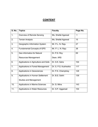
  • 1. CONTENT S. No. Topics Faculty Page No. 1. Overview of Remote Sensing Ms. Shefali Agarwal 1 2. Terrain Analysis Ms. Shefali Agarwal 15 3. Geographic Information System Mr. P.L. N. Raju 27 4. Fundamental Concepts of GPS Mr. P. L. N. Raju 38 5. Geo informatics for Natural Dr. P.S. Roy 69 Resources Management Dean, IIRS 6. Applications in Agriculture and Soils Dr. S.K. Saha 104 7. Applications in Forest Management Dr. S. P.S. Kushwaha 117 8. Applications in Geosciences Dr. P.K. Champtiray 128 9. Applications in Human Settlement Dr. B.S. Sokhi 139 Studies and Management 10. Applications in Marine Sciences Dr. D. Mitra 143 11. Applications in Water Resources Dr. S.P. Aggarwal 154
  • 2. 1 OVERVIEW OF REMOTE SENSING Shefali Agrawal Photogrammetry and Remote Sensing Division 1. Introduction In recent times earth observation from aerospace media has gained significant importance due to ever increasing demand for most authentic, timely and uniform information of earth surface features and processes involved. Due to rapid development and changing life style, the impact on environment and its effect on surface processes and features have under gone sea change. The impact of development on the environment is significant as the rapidly growing population; urbanization and other development efforts have exerted tremendous pressure on natural resources and have caused their depletion and degradation. Biodiversity is declining at an unprecedented rate - as much as a thousand times what it would be without the impact of human activity. Half of the tropical rainforests have already been lost. Land degradation affects as much as two thirds of the world's agricultural land. As a result, agricultural productivity is declining sharply. The conservation measures are far from satisfactory and as development processes and interventions still continue, natural resources will be subjected to greater damage in the future. Hence there is an urgent need to look for alternative strategies and approaches for better and more efficient management of natural resources in order to ensure their sustainable use. This is further compounded by the ever increasing occurrences of natural hazards. Therefore, there is a greater demand for most authentic timely information on a suit of geophysical parameters and environmental indicators. Towards this space provides a vantage point where a large number of sensors have been deployed onboard satellites providing geo spatial information needed to understand the Earth system as a whole. 1.1. Definition of Remote Sensing Remote sensing is the science of acquiring information about the Earth's surface without actually being in contact with it. This is done by sensing and recording reflected Remote Sensing: An Overview for Decision Makers IIRS/LN/DMC/2010
  • 3. 2 or emitted energy and processing, analyzing, and applying that information (Lillesand and Kiefer, 2004).Remote sensing, also called earth observation, refers to obtaining information about objects or areas at the Earth’s surface by using electromagnetic radiation (light) without coming in physical contact with the object or area. The basic process involved in remote sensing is the interaction of the electromagnetic radiation with the Earth's surface and detection at some altitude above the ground. Remote Sensing Systems have four basic components to measure and record data about an area from a distance, Fig1. These components include: • Emission of electromagnetic radiation (EMR) • Transmission of energy from the source to the surface of the earth, as well as absorption and scattering • Interaction of EMR with the earth's surface: reflection and emission • Transmission of energy from the surface to the remote sensor • Sensor data acquisition • Data transmission, processing and analysis Fig.1 Remote sensing process With respect to the type of energy resources, the RS technology is defined as passive or active, Fig 2. Passive Remote Sensing makes use of sensors that detect the Remote Sensing: An Overview for Decision Makers IIRS/LN/DMC/2010
  • 4. 3 reflected or emitted electro-magnetic radiation from natural sources. Active remote Sensing makes use of sensors that detect reflected responses from objects that are irradiated by artificially generated energy sources, such as radar. Fig.2. Passive and active remote sensing With respect to Wavelength Regions, the RS technology is classified as: • Visible and reflective infrared RS operating at a range of 0.4μm to 2.5μm. • Thermal infrared remote sensing operating at a range of 3μm to14μm. • Microwave remote sensing operating at a range of 1mm to1m. Remote Sensing: An Overview for Decision Makers IIRS/LN/DMC/2010
  • 5. 4 ‘Optical range’ Cosmic Gamma X- Radio Electric power U-V Infrared Micro-waves TV rays rays Rays Visible spectrum Ultraviolet Blue Green Red Infrared (IR) 0.3μ m 0.4 0.5μ m 0.6 0.7μ m 10.0 15.0 300nm 500nm 700nm Wavelength Fig.3. Electromagnetic spectrum 1.2 Interaction of EMR with the Earth's Surface Radiation from the sun, when incident upon the earth's surface, is either reflected by the surface, transmitted into the surface or absorbed and emitted by the surface. The EMR, on interaction, experiences a number of changes in magnitude, direction, wavelength, polarization and phase. These changes are detected by the remote sensor and enable the interpreter to obtain useful information about the object of interest. The remotely sensed data contain both spatial information (size, shape and orientation) and spectral information (tone, color and spectral signature). In the visible and reflective Infrared remote sensing region, the radiation sensed by the sensor is that due to the sun, reflected by the earth's surface. A graph of the spectral reflectance of an object as a function of wavelength is called a spectral reflectance curve. Figure shows the typical spectral reflectance curves for three basic types of earth feature vegetation, soil, and water in the visible and reflective Infrared region Fig.4.The band corresponding to the atmospheric window between 8 μm and 14 μm is known as the thermal infrared band. The energy available in this band for remote Remote Sensing: An Overview for Decision Makers IIRS/LN/DMC/2010
  • 6. 5 sensing is due to thermal emission from the earth's surface. Both reflection and self- emission are important in the intermediate band from 3 μm to 5.5 μm. In the microwave region of the spectrum, the sensor is radar, which is an active sensor, as it provides its own source of EMR. The EMR produced by the radar is transmitted to the earth's surface and is reflected (back scattered) from the surface to be recorded by the radar system again. The microwave region can also be monitored with passive sensors, called microwave radiometers, which record the radiation emitted by the terrain in the microwave region. Fig. 4. Typical spectral reflectance curves for vegetation, soil and water. In the microwave region of the spectrum, the sensor is radar, which is an active sensor, as it provides its own source of EMR. The EMR produced by the radar is transmitted to the earth's surface and is reflected (back scattered) from the surface to be recorded by the radar system again. The microwave region can also be monitored with passive sensors, called microwave radiometers, which record the radiation emitted by the terrain in the microwave region. 1.3 Platforms and Sensors In order to enable sensors to collect and record energy reflected or emitted from a target or surface, they must reside on a stable platform away from the target or surface being observed. As space provides one of the most vantage points for earth Remote Sensing: An Overview for Decision Makers IIRS/LN/DMC/2010
  • 7. 6 observation, two prominent orbits are considered for Earth observation: the geo- stationary orbit and the polar orbit. The geo-stationary orbit is such a position that it keeps pace with the rotation of the Earth. These platforms are covering the same place and give continuous near hemispheric coverage over the same area day and night. These are mainly used for communication and meteorological applications. This geo- stationary orbit is located at an altitude of 36,000 km above the equator Fig 5. Fig. 5 Geostationary and near polar orbits The second important remote sensing orbit is the polar orbit. Satellites in a polar orbit cycle the Earth from North Pole to South Pole. The polar orbits have an inclination of approximately 99 degrees with the equator to maintain a sun synchronous overpass i.e. the satellite passes over all places on earth having the same latitude at the same local time. This ensures similar illumination conditions when acquiring images over a particular area over a series of days. The altitude of the polar orbits varies from 600 to 900 km, approximately. 1.4. Resolutions In general resolution is defined as the ability of an entire remote-sensing system, including lens antennae, display, exposure, processing, and other factors, to render a sharply defined image. It depends on large number of factors that can be grouped under: Remote Sensing: An Overview for Decision Makers IIRS/LN/DMC/2010
  • 8. 7 a. Spectral resolution: The spectral band in which the data is collected. b. Radiometric resolution: It is the capability of the sensor to differentiate two objects based on the reflectance / emittance differences. c. Spatial resolution: It is the capability of the sensor to discriminate the smallest object on the ground. Higher the spatial resolution smaller the object that can be identified Spatial resolutions vary from few kilometers to half a meter. d. Temporal resolution: It is the capability to view the same target, under similar conditions at regular intervals. Today a large number of earth observation satellites provide imagery that can be used in various applications. 2. Indian Remote Sensing Satellites India is one of the major providers of the earth observation data in the world in a variety of spatial, spectral and temporal resolutions. India has launched several satellites including earlier generation IRS 1A, IRS 1B, IRS 1C, IRS 1D, IRS P2,IRS P3, IRS P4 and latest P6 and Cartosat series for different applications, the details of these are listed in Table 1. Table 1: Indian Earth Observation Satellites. Spectral Swath Satellite No. of Resolution Revisit Launch Sensors Types Range Width Name Bands (m) (days) (µ) (km) March Cartosat-1 PAN 1 2.5 m 25 2005 0.52 - 0.59 17th 0.62 - 0.68 IRS-P6 October LISS -III MSl 4 23 140 24 0.77 - 0.86 2003 1.55 - 1.70 Remote Sensing: An Overview for Decision Makers IIRS/LN/DMC/2010
  • 9. 8 0.52 - 0.59 0.62 - 0.68 AWiFS MSl 4 56 740 0.77 - 0.86 1.55 - 1.70 0.52 - 0.59 0.62 - 0.68 LISS -IV MS 3 5.8 23.9 5 0.77 - 0.86 LISS -IV PAN 1 0.62 - 0.68 5.8 70 5 OCM MS 8 0.4 - 0.885 360 m 1420 IRS-P4 May 26, 6.6,10.65, 120, 80, 2 (Oceansat) 1999 MSMR RADAR 4 1360 18, 21 GHz 40 and 40 0.62-0.68 (red) WiFS MS 2 189 774 5 0.77-0.86 (NIR) 0.52-0.59 (green) September IRS-1D 0.62-0.68 - 1997 3 23 142 (red) LISS-III MS 0.77-0.86 24-25 (NIR) 1.55-1.70 1 70 148 (SWIR) PAN PAN 1 0.50-0.75 6 70 0.62-0.68 IRS-1C 1995 (red) WiFS MS 2 189 810 5 0.77-0.86 (NIR) Remote Sensing: An Overview for Decision Makers IIRS/LN/DMC/2010
  • 10. 9 0.52-0.59 (green) 0.62-0.68 3 23.6 142 (red) LISS-III MS 0.77-0.86 24-25 (NIR) 1.55-1.70 1 70.8 148 (SWIR) PAN PAN 1 0.50-0.75 5.8 70 450-520 0.52-0.59 LISS-I MS 4 0.62-0.68 72.5 148 IRS-1B 1991 0.77-0.86 22 (NIR) (same as LISS-II MS 4 36.25 74 LISS I) Same as LISS-I MS 4 72.5 148 above IRS-1A 1988 22 Same as LISS-II MS 4 36.25 74 above 3. Global Satellites Global remote sensing satellites include Landsat, SPOT, ASTER, MODIS, MOS, JERS, ESR, Radarsat, IKONOS, QuickBird etc (Table 2): Remote Sensing: An Overview for Decision Makers IIRS/LN/DMC/2010
  • 11. 10 Table 2: Earth Observation satellites from other countries Spectral Swath Satellite No. of Resolution Revisit Launch Sensors Types Range Width Name Channels (m) (days) (µ) (km) 0.43-0.47 (blue) 0.61- 600 x SPOT -5 May 2002 VMI MS 4 0.68(red) 1000 1 120 0.78-0.89( NIR) 1.58- 1.75(SWIR) 0.5-0.59 (green) HRS 0.61-0.68 10 (red) 10 MS 4 60 26 0.79-0.89 10 HRG (NIR) 20 1.58-1.75 (SWIR) 5 m, combined to PAN 1 0.61-0.68 60 generate a 2.5-metre product. Remote Sensing: An Overview for Decision Makers IIRS/LN/DMC/2010
  • 12. 11 10 m (resampled 1 0.61-0.68 at every 60 PAN 5m along track) blue (0.45- 4 2.5 m 17 km 0.52) green (0.52-0.6) MS QuickBird- Oct. 18, red (0.63- 2 2001 0.69) NIR.76- 0.89) PAN 1 0.45-0.9 0.61 m Dec. 5, 12.5 EROS 1 PAN 1 0.5-0.9 1.8 m 1-4 2000 km Terra VNIR - Dec. 18, (EOS AM- 3 stereo (0.5- 15 m 16 1999 1) 0.9) ASTER MS 60 km SWIR (1.6- 6 30 m 2.5) 5 TIR (8-12) 90 m SWIR, TIR, CERES MS 3 20 km Total 360 MISR MS 4 250-275 m km MODIS 2 0.4-14.4 250 m 2330 5 500 m km Remote Sensing: An Overview for Decision Makers IIRS/LN/DMC/2010
  • 13. 12 29 1000 m 640 MOPITT MS 3 2.3 (CH4) 22 km km 0.45-0.52 (blue) 0.52-0.60 (green) IKONOS- September MS 4 IKONOS 0.63-0.69 11 2 24, 1999 (red) 0.76-0.90 (NIR) PAN 1 1M Landsat7 16 TM As Landsat 4-5 30x30 185 705 km 15/04/1999 days Band 6: 10,40 - 60×60 12,50 Panchromatic: 15×15 0,50 - 0,90 NOAA-K May - 1998 AVHRR MS 5 1100 0.5-0.59 VMI MS 4 1000 (green) 0.61-0.68 (red) March 24, 26 SPOT-4 0.79-0.89 1998 MS 4 20 60 HRV (NIR) 1.58-1.75 (SWIR) PAN 1 0.61-0.68 10 60 Remote Sensing: An Overview for Decision Makers IIRS/LN/DMC/2010
  • 14. 13 4. Image Analysis and Interpretation In order to take advantage of and make good use of remote sensing data, we must be able to extract meaningful information from the imagery. Interpretation and analysis of remote sensing imagery involves the identification and/or measurement of various targets in an image in order to extract useful information about them. Much interpretation and identification of targets in remote sensing imagery is performed manually or visually by a human interpreter. It is also possible to apply digital techniques for image analysis and information extraction. 9. Comparison of RS to Traditional Observations RS data, with its ability for a synoptic view, repetitive coverage, observations at different resolutions, provides a better alternative for natural resources management, environmental monitoring and disaster management as compared to traditional methods. It provides images of target areas in a fast and cost-efficient manner. While air photos and fieldwork remain critical sources of information, the cost and time to carry out these methods often make them unviable and the human ability of observation is subjective and individual dependant, thereby making it even more unviable. RS instrumentation makes it possible to observe the environment with EM radiation outside the visible part of the EM spectrum; the invisible becomes visible. RS is flexible in that there is a variety of RS observation techniques and a diversity of digital image processing algorithms for extracting information about the earth's surface. The data can be easily integrated into a Geographical Information System thus making it even more effective in terms of solution offering. 6. Future Prospects In near future large number of new satellites will be launched by India and other countries with capabilities of providing high spatial, spectral and radiometric resolution data for variety of applications like water security, disaster management, natural resource management, food security, infrastructure development etc. The use of geosynchronous orbit for providing high spatial resolution data will be a major break- Remote Sensing: An Overview for Decision Makers IIRS/LN/DMC/2010
  • 15. 14 through to receive bio-geophysical parameters in real time basis. Remote sensing coupled with geographical information systems where the data can be integrated with other information, will provide geo-spatial information that is critical for decision making related to natural resource utilization, environmental monitoring and disaster management. References Lillesand T.M. and Kiefer R. 2004: Remote Sensing and Image Interpretation (Third Edition). John Wiley, New York. Web Links http://www.ccrs.nrcan.gc.ca/ccrs/learn/tutorials/fundam/chapter1/chapter1_2 www.planetary.brown.edu/arc/sensor.html http://www.ersc.edu/resources/EOSC.html www.isro.org www.spaceimage.com www.eospso.gfc.nasa.gov www.landsat.org www.spotimage.fr/home www.space.gc.ca www.esa.int/export/esasa/ESADTOMBAMC_earth_O.html Remote Sensing: An Overview for Decision Makers IIRS/LN/DMC/2010
  • 16. 15 TERRAIN ANALYSIS Shefali Agrawal Photogrammetry and Remote Sensing Division 1. Introduction Terrain components play an important role in natural resource survey, environmental monitoring and natural hazards survey and analysis. Terrain features are the most common features that can be observed from EO systems. Most importantly the 3-D attribute/nature of the terrain can also be mapped and monitored using present generation of EO systems using stereo viewing capability of Cartosat-1, SPOT ALOS Prism etc. and InSAR (Interferometric SAR) capability of Envisat and Radarsat. Terrain features such as elevation, slope, aspect, and curvature influence most of the surface process including soil erosion, slope failures and vegetation composition. One of the most important attributes of terrain, topography influences atmospheric, hydrologic and ecologic processes, such as, microclimate, local wind circulations and precipitation- runoff processes. Soil formation is also a function of relief, slope and geomorphology. Topographical features such as drainage basins, stream networks and channels, peaks and pits, drainage divides (ridges) and valleys play an important role in hydrological modeling related to flooding, locating areas contributing pollutants to a stream, estimating the effects of altering the landscape etc. Relief information is also required for removal of terrain distortions in aerial and satellite images and for creation of orthorectified image maps. Terrain visualization has also an important place in military and civil engineering operations. Based on the above application requirements and EO opportunities, a lot of emphasis is given on extraction of terrain features from using optical, radar, and Lidar data sets. 2. Digital Elevation Model (DEM) The most important aspect of the terrain is relief that can be represented as a Remote Sensing: An Overview for Decision Makers IIRS/LN/DMC/2010
  • 17. 16 continuous surface in the form of a Digital Elevation Model (DEM). In GIS, DEM is used to refer specifically to a regular grid of spot heights. It is the simplest and most common form of digital representation of topography. The term Digital Terrain Model (DTM) may actually be a more generic term for any digital representation of a topographic surface. DEM, can be generated from the following basic relief information. a) Contour lines: Usually elevations on a topographic map are represented as a group of contour lines with a discrete and constant contour interval. b) Grid data: For convenience of computer processing, a set of grid data with elevation are acquired from contour maps, aerial photographs or stereo satellite image data. Terrain data other than the grid data are interpolated from the surrounding grid data. c) Random point data: Terrain features are sometimes represented by a group of randomly located terrain data with three-dimensional coordinates. For computer processing, random point data are converted to triangulated irregular network (TIN). TIN has the advantage of easy control of point density according to the terrain feature, though it has the disadvantage of being time consuming in the random search for the terrain point. d) Surface function: Terrain surface can be expressed mathematically as a surface function, for example, a Spline function 3. Elevation Data Sources Elevation data can be obtained from the following sources • Survey data: including ground-based leveling and satellite-based GPS data; • Remotely sensed data: including radar altimeter data, laser altimeter data, optical and SAR stereoscopic image pairs, complex interferometric SAR data, and shade information in single images; and Remote Sensing: An Overview for Decision Makers IIRS/LN/DMC/2010
  • 18. 17 • Cartographic data: including contours, spot height points and surface structural lines digitized from paper topographical map sheets. Each data source has its own inherent strengths and limitations in terms of the availability, accuracy, sampling density and pattern, and the ground coverage. 4. Elevation Data Acquisition Techniques At present a number of techniques are available for acquiring digital elevation data. The ground survey and aerial photogrammetry represent the traditional elevation extraction and measurement techniques. Contour-based topographical maps have long been the primary storage media for terrain information throughout the world. GPS, satellite image based stereoscopic technique, SAR interferometry, radar altimetry, and laser altimetry are relatively new techniques for digital elevation acquisition. The advent of new data capture technologies has increased the acquisition speed of elevation data, improved the position and height measurements, extended their ground coverage, and reduced the cost. Ground survey and satellite-based GPS technology tend to generate very accurate positional and height measurements. Since both ground survey and GPS techniques require physical visit of ground sampling points, the resulting measurements are usually sparse. Often, they are utilized as GCPs (Ground Control Points) for extracting more dense elevation data from stereo photogrammetric and InSAR techniques or used as checking points for the DEM accuracy assessment. 5. Digitizing Topographic Maps Due to the relatively low cost and the widest availability, the digitization of topographical maps represents the practical method for gathering digital elevation data for a large area, particularly for national and continental scale projects. Cartographic data are the second hand topographical information source, in the sense that they are originally derived from direct height measurements of some kind. The information Remote Sensing: An Overview for Decision Makers IIRS/LN/DMC/2010
  • 19. 18 content of a topographical map depends on not only the quality of original source data but also map scale and contour interval. In addition to contours and spot heights, topographical maps may also contain, implicitly or explicitly, many important terrain features such as surface break lines, ridges and drainage lines. 6. Photogrammetry-Based Stereo Technique The photogrammetry-based stereo technique derives the digital elevation data based on parallax differences between a stereo image pair. The principle is simple; first, two images are acquired of the same area with slightly different viewing perspectives (stereo-overlap). These images are then aligned and geometrically matched so that a mathematical (triangulation) model can be obtained. The analyst then has the opportunity to view the modeled stereo pair in 3D to manually extract the terrain information or use automated stereo correlation tools to extract a new DTM. The automated process is typically used when the surface landscape needs to be extracted. “Above-the-landscape” features (e.g., buildings) are typically derived manually (using stereo extraction tools) and then “placed” on the DTM. The accuracy of the elevation data derived from stereo technique is often influenced by mismatch of conjugate image pixels, and errors of the sensor position and attitude. The current and future high- resolution earth observation satellites (table 1) having a spatial resolution of 1m & less and stereo capabilities will go a long way in the field of mapping in terms of cost, time and accuracy. Table 1: High resolution sensors Sensor Launch Date Resolution IRS-1C 28-DEC-95 Panchromatic: 5.8 m IRS-1D 29-SEP-97 Panchromatic: 5.8 m IKONOS 24-SEP-1999 Panchromatic: 1 m Multispectral: 4 m Remote Sensing: An Overview for Decision Makers IIRS/LN/DMC/2010
  • 20. 19 QuickBird 18 October 2001 Panchromatic: .61 m Multispectral: 2.44 m EROS A1 05-DEC-2000 1.8m CBERS 3 2003 Panchromatic: 5 m EROS B1 2003 Panchromatic: .81 m EROS B2 2003 Panchromatic: .81 m Multispectral: 3.3 m SPOT- 5 1985 Panchromatic: 2.5m from 2 x 5m scenes Panchromatic: 5m (nadir) Terra-ASTER December 1999 Multispectral (B1-B3) 15m Cartosat-1 May 2005 (Panchromatic): 2.5 m ALOS - PRISM January 2006 Panchromatic: 2.5 m WorldView 1 September 2007 Panchromatic: 0.55 m GeoEye-1 August 2008 Panchromatic – 0.41m Multispectral : 1.65m Fig. 1. Photogrammetric technique (www.univcalagary) Remote Sensing: An Overview for Decision Makers IIRS/LN/DMC/2010
  • 21. 20 7. Synthetic Aperture Radar (SAR) Interferometry Incidence Revisit Year of Ban Polarizatio Swath Resolut SAR sensor angle (days) launch d n (km) ion (m) (deg.) The interferometric SAR (InSAR) technique has emerged as a precise approach to the extraction of high-resolution elevation data and measurement of very small surface motion (displacement); InSAR technique is based on the phase information derived from the complex radar images. SAR interferometry combines complex radar signals (images) recorded by the antenna at slightly different locations to measure the phase differences between the complex radar images. Relating two complex SAR images of the same scene acquired at two orbital locations forms an interferogram. As the radar signal transmitted by the SAR sensor is coherent, the complex SAR image possesses both phase and magnitude (quantities) information. The constructive and destructive interference of coherent SAR images respectively recorded at slightly different locations produce an interferogram with a two-dimensional fringe pattern, which can be unwrapped into the absolute measurement of elevation. Fig. 2. Principle of SAR interferrometry (www.aerosensing.com) Remote Sensing: An Overview for Decision Makers IIRS/LN/DMC/2010
  • 22. 21 ERS-1 1991 C VV 23 100 30 35 JERS-1 1992 L HH 35 75 18 44 ERS-2 1995 C VV 23 100 30 35 Radarsat-1 1995 C HH 10 to 50 40-500 8-100 24 SRTM 2000 X, C VV Variable 30-350 20-30 HH/HV, 100- 30- Envisat-1 2002 C 14 to 45 35 VV/VH 400 1000 VV, HH, PALSAR 2004 L HH/HV, 18 to 55 70 10-100 44 VV/VH TerraSAR-X 2006 X Quad-pol 10 to 100 15-60 2-16 11 Radarsat-2 2008 C Quad-pol 10 to 50 10-500 8-100 24 20 to 49 (qualified) 10 to 20 RISAT 2008 C Quad-pol 10-240 3 - 50 13 and 49-54 (unqualifie d) Table 2: SAR satellites and sensors 8. Radar Altimetry Spaceborne radar altimeters have been deployed on board of Geosat, Seasat and ERS-1 platforms for acquiring surface height measurements. A radar altimeter is a nadir-pointing active microwave sensor designed to measure the surface height over ocean and ice surfaces. The radar altimeter transmits a short duration Ku-band pulse vertically downwards, and then tracks the returned radar pulse. The information of the shape and timing of the returned signal is utilized to estimate the surface height. Remote Sensing: An Overview for Decision Makers IIRS/LN/DMC/2010
  • 23. 22 Radar altimeters can provide accurate elevation measurements regardless of weather condition over ocean and relatively flat and low-slope ground surface, but are prone to errors over highly sloped and rugged lands due to the relatively large footprint. 9. Laser Altimetry A laser altimeter can provide height measurements of submeter level accuracy with the aid of GPS and Inertial Navigation System (INS) in determining the position and attitude of aircraft or spacecraft, but the data collection is usually time consuming due to its narrow ground swath. Laser altimeter data may deteriorate in the condition of bad weather, such as clouds and precipitation, it generally provides much more accurate measurements than the radar altimeter due to the small footprint of the laser beam. Fig. 3. Principle of laser scanning (www.terraimaging.com) 10. Derivation of Surface Parameter 10.1 Elevation If the point of interest is exactly at a point in the raster, the elevation can be taken directly from the database If the point of interest is between nodes of DEM grid, we need to interpolate from neighboring grid points, e.g. bilinear, cubic, or fit a plane to the nearby raster points. Remote Sensing: An Overview for Decision Makers IIRS/LN/DMC/2010
  • 24. 23 10.2 Slope Measure the surface steepness; Slope is rise over reach (rise/reach), where rise is the change in elevation, and reach is the horizontal distance. It is expressed as: a ratio, a simple fraction, a percent, an angle in degrees. 10.3 Aspect (azimuth orientation) Aspect is azimuthal direction of maximum surface slope with reference to true north. Aspect calculation is very sensitive to elevation errors, especially when the surface slope is small. Without a slope, there is no topographic aspect. The aspect at each location determines the direction of water flow over the terrain surface. 10.4 Surface Curvature (convergence/ divergence) The surface curvature is the second derivative of the surface (i.e., the slope of the slope); the curvature of a surface can be calculated on a cell-by-cell basis. For each cell, a fourth-order polynomial of the form is fit to a surface composed of a 3x3 window. 10.5 Profile Curvature The curvature of surface in the direction of slope is referred to as the profile curvature. Profile curvature indicates where the surface is concave or convex, resulting acceleration or deacceleration of flow. Where acceleration of flow occurs, the stream gains energy and its ability to transport particles increases. Therefore, areas of convex profile curvature indicate areas of erosion. Conversely, in areas of concave profile curvature, the flow rate decreases, the stream loses energy, and deposition occurs. Remote Sensing: An Overview for Decision Makers IIRS/LN/DMC/2010
  • 25. 24 10.6 Planform Curvature The curvature of a surface perpendicular to the direction of slope is referred to as the planform curvature. Planform curvature indicates where the surface is concave or convex, resulting in convergence or divergence of flow respectively; Convergent flow indicates a concentration of runoff and would indicate a valley. Alternatively, divergent flow would indicate a ridge. 10.7 Cut and Fill Calculation Estimation of the volume of material related to cutting and filling. By subtracting the upper (top) surface height values from the lower surface height, a variable thickness (depth) value can be obtained. The thickness values over the entire area can be integrated to obtain the volume. Engineers need to establish road or railroad routes and gradients that minimize the movement of earth. It is generally most economical to balance the amount of material removed from the high areas (cut) with the amount of material required to fill low areas (fill). Also used in Reservoir capacity estimation, ice volume, etc. 11. Viewshed Analysis A viewshed is the region that is visible from a given vantage point in the terrain. It assembles all the areas where the line of sight is rising as the rays move outwards. The yes/no values can be summed to give a cumulative sense of how many times a place is seen. Inter-visibility (what can be seen from where) can be computed based on a set of rays radiating outwards from a vantage point. In a complex 3D situation, there are many effects to calculate, but on a surface the surface can only obstruct a view by rising above the line of sight. Applications of viewshed analysis include GPS signal availability, scenic beauty evaluation, sitting television, radio, and cellular telephone transmitter and receiver towers, locating towers for observing forest fires or enemy movement. Remote Sensing: An Overview for Decision Makers IIRS/LN/DMC/2010
  • 26. 25 12. Watershed Analysis The shape of a terrain determines the movement of water across the terrain surface; Water will flow from higher locations downwards. A raster DEM contains sufficient information to determine pattern and characteristics of a drainage basin, such as, the upstream area contributing to a specific location and the downstream path water would follow, the boundary of catchment area, flow line, ridges, the hierarchical stream system, etc. The topology of terrain surface (skeleton of surface): peaks, pits, ridges, courses (valleys), hills and dales, etc. The area upon which water falls, and the network through which it travels to an outlet is referred to as a drainage system. The flow of water through a drainage system is only a subset of the hydrologic cycle, which also includes precipitation, evaporation, and groundwater; Watersheds tend to function ecologically as single, uniform regions. Ecologists, hydrologists, engineers, pollution and flood control experts need to be able to define these areas precisely. 13. Dem Visualization There are number of techniques to enhance and display DEM data. Shaded relief is also one of the techniques, which is considered to be one of the most effective techniques for representing topography. 13.1 Shading The gradation from dark to light in a single color according to specific principals for the purpose of creating a three dimensional effect is called shading. In contrast to the metric accuracy of contour lines, hill shading is primarily used for its visual effects. Slope shading operates on the principal that the steeper the slope - the darker the shade. Oblique shading or hill shading is based upon the effect of an oblique light source on a terrain surface. Remote Sensing: An Overview for Decision Makers IIRS/LN/DMC/2010
  • 27. 26 13.2 Slope Shading Slope shading, operates basically on the principal of the steeper - the darker. 13.3 Hill Shading Hill shading is also known as a shaded relief or simply shading, it attempts to simulate how the terrain looks with the interaction between sunlight and surface features. It Helps viewers recognize the shape of landform features on a map. 14. Conclusions Terrain analysis typically encompasses numerical methods of describing landscape attributes such as terrain roughness, vegetation, urban features, 3D models etc. To fully model the continuous terrain surface, a large number of points are required and DEM and TIN are two commonly used models of representing the continuous topographic surface in digital form with a finite number of sample points. Most of the commercial GIS systems provide both raster DEM and TIN model that can be used in spatial analysis and surface modeling. However, it is important to note that the most critical aspect of any terrain analysis is the accuracy of the terrain model it uses or how close the data model either DEM/TIN represents the actual surface with all attributes. Web Links www.isprs.org www.terraimaging.com www.aerosensing.com Remote Sensing: An Overview for Decision Makers IIRS/LN/DMC/2010
  • 28. 27 GEOGRAPHIC INFORMATION SYSTEM P.L.N. Raju Geoinformatics Division 1. Significance of GIS in the Present Day Scenario Geographic Information System plays an important role in creation of geospatial information from vast sources such as analogue and digital domains, and aid the decision makers at various junctures of resource identification, assessment and management. It can answer many simple questions like what, where, how as well as complex situations of using models for estimation, prediction and dynamically recreate real world situation to visualise and fly though the area for effective planning and management. GIS is becoming quite popular in the recent past among the general public with the introduction of Google earth (http://earth.google.com), Microsoft Virtual earth (http://www.microsoft.com/virtualEarth/) and NASA’s Worldwind (http://worldwind.arc.nasa.gov) for viewing rich Geographic content in the form of satellite pictures/maps in 2D/3D, explore, locate, navigate etc. With the help of these resources people can find their location, assess the present situation and find them the route to reach the destination, overlay the new surveyed routes and other information. World wide web has also become the source for viewing Geographic information in the form of maps and location information like Maps of India (http://mapsofIndia.com). All types of tools used to carry out these tasks are part of GIS with the background of satellite image. The 3d view and animation that we carry out on the images are carried out using GIS tools. Third Generation mobile devices are integrated with (GPS) receiving capability are loaded with Geographic information (i.e. GIS data) and used to find where you are located and giving directions to reach the desired destination (i.e. house/office/tourist destination etc). This summary note outlines status of GIS that includes importance of GIS and its role for different application studies, journey of GIS from a mere a tool to science, how important it is to create a geospatial database and its critical nature, transformation of GIS from commercial nature to the present potential of having many open source and free software for the user community, progress of GIS and its Remote Sensing: An Overview for Decision Makers IIRS/LN/DMC/2010
  • 29. 28 market potential as on today, where to look and find different GIS resources in World Wide Web and finally summarising the technological trends and future of GIS. 2. GIS Application Potential The strength of GIS depends upon how good is the geospatial database. It can be used for natural resource application (i.e. forestry, agriculture and water resources etc.) in combination with remote sensing and earth observation. In addition it is used for infrastructure development (i.e. highways, railways etc.); utility services like water supply distribution network, telephone network management, gas supply distribution etc.; business application such as real estate, establishment of new retailer shops; heath services; investigation services like crime incidences and their distribution etc and geospatial information kiosks like Bhoomi project (http://www.kar.nic.in/bhoomi.html) of Karnataka State. In addition GIS can be used for research and scientific investigations, particularly for water budgeting, atmospheric modelling, climatic studies and global warming. 3. GIS: Tool to Science GIS has evolved from a mere tool into a spatial science covering broad spectrum of fields starting from surveying, mapping, modelling, and management to decision theory. A discussion forum was launched on “GIS is a tool or science?” was initiated in 1993 brought out many views about GIS (Wright et al., 1997): some strongly feel that it is considered merely a tool as it helps only in manipulation of spatial data, combines elements of computer science, geography and enabling technology in problem solving environment (Skelly, 1993); Petican,1990); Groom,1993); Feldman,1993). At the same time, many others argue that it is not only a tool but also it is definitely a science as it addresses vast issues such as understanding of modelling spatial phenomena (Carlson, 1993), study of spatial data uncertainty and error, data lineage and how GIS is adopted by agencies (Wright 1993 et al.,), spatial data representation and developing algorithms to solve a problem and apply it to test a theory (Sandhu, 1993). According to some, GIS is considered as part of a broader information science (Wright et al., 1993), an environment as well as a method used to discover, explore, and test spatial theory Remote Sensing: An Overview for Decision Makers IIRS/LN/DMC/2010
  • 30. 29 (Laffey, 1993) and concepts that the tools seek facilitate, automate, and develop are strongly rooted in science (Bartlett, 1993). Amidst diverse views, growth of GIS is phenomenal and expanded to many areas like Environmental and Earth Sciences, Urban Planning & Infrastructure Development, Socio- Economic outreach, business enterprise and technological domains, covering them under geoinformatics umbrella and making itself an inevitable scientific field. 4. Critical Part of GIS Hardware, Software, Data and trained Manpower makes it to total GIS. Though each component is important, the most critical part of GIS is data, i.e. creation of data needs three forth of cost involved to develop the total GIS application project, highly trained professional are required to be part of geospatial database creation and three fourth’s time is spend to accomplish the task of creating the geospatial database. All the users require the basic framework data like common datum and projection, administrative, roads, topographical and land use / land cover layer information. The issue is creation of the same by one and use it by many. All countries are in the process of creating it and it takes lot of time. India is also in the process of developing at national level (i.e. National Resource Repository (NRR) under ISRO /NNRMS and National Spatial Data Infrastructure (NSDI) under DST and many others are in the process of development which in turn helps for overall development and progress of India. 5. GIS Software: Commercial vs. Open/Free GIS software is one of the bottlenecks in GIS industry as the major junk money (~50 per cent or so) is invested towards its procurement and maintenance annually. Because of it many users have apprehensions to change from conventional methods to GIS. In the recent past there is a paradigm shift in usage of GIS software. There are many new and open/free software are launched into the market. The free software where it is freely available and mostly through www but the user do not have access to program coding, so not possible to modify or update it. In case of open source, it is free as well as available with full access to program Remote Sensing: An Overview for Decision Makers IIRS/LN/DMC/2010
  • 31. 30 coding so user can modify/update it according to his requirements. Table 1 below provides list of some of commercial, open and free GIS software. Table 1: List of GIS software available commercially/as a open source/freely to the user. S.No. Software Functionality /Remarks Commercial Software 1. ArcGIS Core modules,market leader but high cost, many more to be bought for other applications 2. Geomedia Core modules of GIS, supports education and research institutions 3. MapInfo Moderate cost 4. AutoCAD Map Better input and database creation facility 5. JTMaps Quite economical and works in vector model (India) Open Source 6. GRASS GIS Satellite data analysis & GIS (http://grass.itc.it/) 7. Quantum GIS Desktop GIS, supports all OS (http://qgis.org/) 8. ILWIS Satellite data analysis & GIS (www.itc.nl) 9. JUMP Read shp and gml format, display facility and support for wms and wfs, limitations of working with large data files (http://jump-project.org/) 10. PostGIS With spatial extensions for the open source. PostgreSQL database, allowing geospatial queries (http://postgis.refractions.net/) 11. Mapserver Web server GIS S/W (http://mapserver.gis.umn.edu/) Free Software 12. ArcView Limited analysis functionality, old version 13. TNTMIPS Satellite data analysis and GIS but limited to window size 6. Indian Geospatial Market Indian Geospatial market has matured well and growing at much higher rate than normal growth. Geospatial market can divide into three categories such as: Remote Sensing: An Overview for Decision Makers IIRS/LN/DMC/2010
  • 32. 31 spatial data producing agencies, user organizations (government, private, and research and academic setup) and industry (private entrepreneurs). As per the market survey and compilation work done by GIS development (Indian Geospatial Handbook 2008, published by GIS Development Pvt. Ltd.) the growth for the last three years (i.e. 2005 to 2008) is phenomenal and it is more 45 per cent increase from the previous years. The annual turnover increased from Rs. 760 crores in 2005 that includes GIS (540), photogrammetry (120) and Image Processing (100) to Rs. 1128 crores in 2006, i.e. an increase of 48 per cent. It is further increased to more than double i.e. Rs. 1780 crores. The details of overall Geospatial Industry including software, hardware and Services, are shown in Table 2. Table 2: Status of GIS revenue during 2005-08 period (Crores of rupees) (source: GIS 540 800 1250 Photogrammetry 120 188 350 Image Processing 100 140 180 Total 760 1128 1780 Increase (%) - 48 58 Indian Geospatial Handbook, 2008). There are many institutions / organizations which generate Remote Sensing and Geo-Information products and provide services such as (SOI, NRSA, NATMO, GSI, FSI, CGWB, CWC, IMD, Census & ANTRIX etc.) and the products and services are used by many user organizations like Highways, Railways, Airways, Waterways, Telecom, Power, Water resources & Irrigation, Health, Education, Environment & Forest, Agriculture, Urban Development and Land Resources and Rural Development etc. Geospatial entrepreneurs mainly owned by private provide value added services to the above said user organizations. There are around 120 companies are involved in Geospatial industry, majority of contribution i.e. 85 per cent of the revenue is generated by 15 per cent of companies. The top four companies are Infotech Geospatial India (30 per cent), RMSI (4 per cent ), Wapmerr India (0.6 per cent) and Pixel Group (0.6 per cent). The manpower required for geospatial industry is met with many who had acquired their higher education / professional qualifications from more than forty programs in geospatial education, range from P.G. Diploma, and graduate in engineering to Masters in Remote Sensing: An Overview for Decision Makers IIRS/LN/DMC/2010
  • 33. 32 Engineering/Technology/Science, are presently being run across the country at university/ institutions level. 7. GIS Web Resources World Wide Web has become an important source for accessing resources of remote sensing, GIS and GPS in which one can even download the satellite data, GIS metadata, GIS themes, access to reading material, latest developments in the form of articles from newsletters, journals. One can access to online resources on payment basis and many cases freely as well. Table 3 provide summary of few GIS resources, emphasizing more in Indian context. Table 3: GIS web resources S.No. Hosted by and Website link Nature of resources Web access to Geospatial Information in India 1. National Natural Resources Natural Resource Repository (NRR) Information System generated under NNRMS, ISRO/DOS http://www.nnrms.gov.in National Remote Sensing Centre Browsing Indian Remote Sensing 2 http://www.nrsc.gov.in (IRS) data and buying for anywhere in India National Informatics Centre RS & GIS basic reading material 3. http://gis.nic.in/ National level spatial information search facility Indian National Centre for Ocean Provide ocean information and 4. Information Service (INCOIS) advisory services to the society, http://www.incois.gov.in/ industry, government, and scientific community Meteorological and Oceanographic Meteorological and Oceanographic 5. Satellite Data Archival Centre geophysical data products http://www.mosdac.gov.in/ Web Access to Geospatial Information World over Remote Sensing: An Overview for Decision Makers IIRS/LN/DMC/2010
  • 34. 33 1. USGS Education material Common place to refer for education http://education.usgs.gov/ material on RS, GIS and GPS CGIAR consortium for spatial Site for downloading SRTM DEM 2. information data at 90 m resolution http://srtm.csi.cgiar.org/ GIS Reading Material 1. GIS Development monthly GIS reading material and published magazine articles in the magazine for more than http://gisdevelopment.net ten years My Coordinates monthly magazine GPS, GIS and RS reading material 2. http://www.mycoordinates.org/ with more emphasis on positioning technology 3. Indian Society of Geomatics Newsletter (quarterly) on RS, GIS http://www.isgindia.org/ and GPS NNRMS Bulletin Biannual technical publication from 4. ISRO/NNRMS bringing out RS & GIS application project outputs Geospatial Today Monthly magazine on Geospatial 5. http://www.geospatialtoday.com/ technologies Geo Place Website of multiple GIS and business 6. http://www.geoplace.com/ related publications 8. Technological Trends and Future of GIS Information and Communication Technology (ICT) has revolutionized and helped GIS to great extend. According to Peter Croswell (2005) five important trends have exerted profound influence on geo-technology industry and user community: • Pervasive high-performance computing • Digital connectivity • Geographic data capture and compilation • Geographic data management and visualization • Standards and open system Remote Sensing: An Overview for Decision Makers IIRS/LN/DMC/2010
  • 35. 34 Moore (Moore’s law) has predicted more than 25 years back that the processing power of computers doubles every 18 months for the same cost and this is true even today. Increase in processing speed, availability of computers at affordable cost, increase of analysis functionalities, and availability of web resources made it possible in expanding the scope of GIS. In the last five years, hardware advances have offered GIS users a growing array of realistic and effective solutions for field and mobile computing needs as well. The Internet has been a driver for overall IT development, and it forced the trend in digital connectivity. It has lead to the development of Internet GIS (also called web GIS), that has played a major role in expanding the GIS usage, helping the users to access the geoinformation at low cost in client-server environment and it will continue to further with standards and better services. GIS technology has always been a tool for data visualization- portraying complex spatial data and patterns through the use of 2-D and 3-D maps and displays. Technology for the visualization of geographic information has taken significant leaps in the last 25 years. During this time, GIS users have seen tremendous advances in graphic display and large-format plotting. Realistic 3-D city models as well as 3-D environment data; atmosphere and ocean in individual horizontal layers can be investigated. Open standards and specifications has become an issue due to the diverse formats and structures from different software have complicated the integration efforts. Over the last ten years major developments have taken place for the open standards and specifications. OCC (Open Geospatial Consortium), ISO-TC 211, GSDI and many others at worldwide and country level played a key role in development of these standards and it is continuing to expand along with the ICT technological trends. As indicated above, the technological trends can be categorized into five and summarized in the following Table 4 ( Dadhwal and Raju, 2006). Remote Sensing: An Overview for Decision Makers IIRS/LN/DMC/2010
  • 36. 35 Table 4: Technological trends S.No. Category Technological Trends 1. Data • Multispectral to Hyper-spectral • Low Spatial resolution to High Spatial resolution • Mono imaging to Stereo Imaging • Workstation to PC based 2. Hardware • Workstation to PC based • PCs to Mobile / pocket PCs 3. Software • Desktop level to web based GIS/Image • analysis to Mobile GIS 4. Internet • Low bandwidth – Broad brand based • Web services (Google Earth / Wekemepia etc.) 5. Standards • Proprietary based standards to Open • Standards As a whole the technological developments in geoinformatics lead to branch out to many areas. They are: • spatial multimedia • open GIS/ Free GIS • GIS Customization • spatial Modelling • geo-Visualization • data Warehouse and large database handling • knowledge discovery and Data mining • geo-Computation • mobile GIS /Fleet Management / Location Based Services • web GIS /Distributed GIS • spatial Data Infrastructure and Geo-Information Management • sensor Web enablement • metadata and clearing houses Remote Sensing: An Overview for Decision Makers IIRS/LN/DMC/2010
  • 37. 36 • interoperability/Open standards and specifications References Bartlett, D. 1993. Geography Department, Cork University, Ireland. Re: GIS as a Science [Discussion]. GeographicInformation Systems Discussion List [Online] Carlson, C. L. 1993. Northern Illinois University. Re: Value of Peer Review [Discussion]. Geographic Information Systems Discussion List [Online] Feldman, M. 1993. Community Planning, University of Rhode Island. Re: GIS as a Science & Value of Peer Review [Discussion]. Geographic Information Systems Discussion List [Online]. Groom, A. 1993. Christchurch City Council, New Zealand. Re: Tool or Science? [Discussion]. Geographic Information SystemsDiscussion List [Online]. Laffey, S. C. 1993. Department of Geography, Northern Illinois University. Re: GIS as a Science [Discussion]. GeographicInformation Systems Discussion List [Online]. Petican, D. J. 1993. University of Waterloo, Canada. Re: GIS as a Science [Discussion]. Geographic Information SystemsDiscussion List [Online]. Sandhu, J. 1993. Environmental Systems Research Institute, Redlands. Re: GIS as a Science [Discussion]. Geographic Information Systems Discussion List [Online]. Skelly, C. W. 1993. James Cook University, Australia. GIS & Remote Sensing Research [Discussion]. Geographic Information Systems Discussion List [Online] Remote Sensing: An Overview for Decision Makers IIRS/LN/DMC/2010
  • 38. 37 Dadhwal,V.K and Raju,P.L.N. 2006. Geoinformatics technological trends – expanding to diversified application areas, National Conference on Geo Informatics, V.P.M’s Polytechnic, Thane, Maharastra, December 8-10, 2006. Wright, D. J. 1993a. Department of Geography, UC-Santa Barbara. Re: Value of Peer Review [Discussion]. Geographic InformationSystems Discussion List [Online] Wright, Dawn J., Goodchild, Michael F and Proctor, James D. 1997. “Demystifying the Persistent Ambiguity of GIS as “Tool” Versus “Science””Annals of the Association of American Geographers, 87(2): 346-362, 1997. Remote Sensing: An Overview for Decision Makers IIRS/LN/DMC/2010
  • 39. 38 Fundamental Concepts of GPS P.L.N. Raju Geoinformatics Division Introduction: Traditional methods of surveying and navigation resort to tedious field and astronomical observation for deriving positional and directional information. Diverse field conditions, seasonal variation and many unavoidable circumstances always bias the traditional field approach. However, due to rapid advancement in electronic systems, every aspect of human life is affected to a great deal. Field of surveying and navigation is tremendously benefited through electronic devices. Many of the critical situations in surveying/navigation are now easily and precisely solved in short time. Astronomical observation of celestial bodies was one of the standard methods of obtaining coordinates of a position. This method is prone to visibility and weather condition and demands expertise handling. Attempts have been made by USA since early 1960`s to use space based artificial satellites. System TRANSIT was widely used for establishing network of control points over large regions. Establishment of modern geocentric datum and its relation to local datum was successfully achieved through TRANSIT. Rapid improvements in higher frequently transmission and precise clock signals along with advanced stable satellite technology have been instrumental for the development of global positioning system. The NAVSTAR GPS (Navigation System with Time and Ranging Global Positioning System) is a satellite based radio navigation system providing precise three- dimensional position, course and time information to suitably equipped user. GPS has been under development in the USA since 1973. The US Department of Defence as a worldwide navigation and positioning resource for military as well as civilian use for 24 hours and all weather conditions primarily develops it. In its final configuration, NAVSTAR GPS consists of 21 satellites (plus 3 active spares) at an altitude of 20200 km above the earth’s surface (Fig.1). These satellites are Remote Sensing: An Overview for Decision Makers IIRS/LN/DMC/2010
  • 40. 39 so arranged in orbits to have at least four satellites visible above the horizon anywhere on the earth, at any time of the day. GPS Satellites transmit at frequencies L1=1575.42 MHz and L2=1227.6 MHz modulated with two types of code viz. P-code and C/A code and with navigation message. Mainly two types of observable are of interest to the user. In pseudo ranging the distance between the satellite and the GPS receiver plus a small corrective term for receiver clock error is observed for positioning whereas in carrier phase techniques, the difference between the phase of the carrier signal transmitted by the satellite and the phase of the receiver oscillator at the epoch is observed to derive the precise information. The GPS satellites act as reference points from which receivers on the ground resect their position. The fundamental navigation principle is based on the measurement of pseudoranges between the user and four satellites (Fig.2). Ground stations precisely monitor the orbit of every satellite and by measuring the travel time of the signals transmitted from the satellite four distances between receiver and satellites will yield accurate position, direction and speed. Though three-range measurements are sufficient but fourth observation is essential for solving clock synchronization error between receiver and satellite. Thus, the term "pseudoranges" is derived. The secret of GPS measurement is due to the ability of measuring carrier phases to about 1/100 of a cycle equaling to 2 to 3 mm in linear distance. Moreover the high frequencies L1 and L2 carrier signal can easily penetrate the ionosphere to reduce its effect. Dual frequency observations are important for large station separation and for eliminating most of the error parameters. There has been significant progress in the design and miniaturization of stable clock. GPS satellite orbits are stable because of the high altitudes and no atmosphere drag. However, the impact of the sun and moon on GPS orbit though significant can be computed completely and effect of solar radiation pressure on the orbit and tropospheric delay of the signal have been now modeled to a great extent from past experience to obtain precise information for various applications. Remote Sensing: An Overview for Decision Makers IIRS/LN/DMC/2010
  • 41. 40 Comparison of main characteristics of TRANSIT AND GPS reveal technological advancement in the field of space based positioning system (Table 1) Details TRANSIT GPS Orbit Altitude 1000 Km 20,200 Km Orbital Period 105 Min 12 Hours Frequencies 150 MHz 1575 MHz 400 MHz 1228 MHz Navigation data 2D : 4D : X,Y,Z, t velocity Availability 15-20 minute per pass Continuously Accuracy ñ 30-40 meters ñ15m (Pcode/No. SA (Depending on velocity 0.1 Knots error) Repeatability ------- ñ1.3 meters relative Satellite Constellation 4-6 21-24 Geometry Variable Repeating Satellite Clock Quartz Rubidium, Cesium GPS has been designed to provide navigational accuracy of ±10m to ±15 m. However, sub meter accuracy in differential mode has been achieved and it has been proved that broad varieties of problems in geodesy and geodynamics can be tackled through GPS. Versatile use of GPS for a civilian need in following fields have been successfully practiced viz. navigation on land, sea, air, space, high precision kinematics survey on the ground, cadastral surveying, geodetic control network densification, high precision aircraft positioning, photogrammetry without ground control, monitoring deformations, hydrographic surveys, active control survey and many other similar jobs related to navigation and positioning,. The outcome of a typical GPS survey includes geocentric position accurate to 10 m and relative positions between receiver locations to centimeter level or better. Remote Sensing: An Overview for Decision Makers IIRS/LN/DMC/2010
  • 42. 41 Various Segments: For better understanding of GPS, we normally consider three major segments viz. space segment, Control segment and User segment. Space segment deals with GPS satellites systems, Control segment describes ground based time and orbit control prediction and in User segment various types of existing GPS receiver and its application is dealt (Fig.3). Table 2 gives a brief account of the function and of various segments along with input and output information. Segment Input Function Output Space Navigation message Generate and P-Code Transmit code and C/A Code carrier phases and L1,L2 carrier navigation message Navigation message Control P-Code Observations Produce GPS time Navigation message Time predict ephemeris manage space vehicles User Code observation Carrier Navigation solution Position velocity phase observation Navigation Surveying solution time Message GLONASS (Global Navigation & Surveying System) a similar system to GPS is being developed by former Soviet Union and it is considered to be a valuable complementary system to GPS for future application. Space Segment: Space segment will consist 21 GPS satellite with an addition of 3 active spares. These satellites are placed in almost six circular orbits with an inclination of 55 degree. Orbital height of these satellites is about 20,200 km corresponding to about 26,600 km Remote Sensing: An Overview for Decision Makers IIRS/LN/DMC/2010
  • 43. 42 from the semi major axis. Orbital period is exactly 12 hours of sidereal time and this provides repeated satellite configuration every day advanced by four minutes with respect to universal time. Final arrangement of 21 satellites constellation known as "Primary satellite constellation" is given in Fig.4. There are six orbital planes A to F with a separation of 60 degrees at right ascension (crossing at equator). The position of a satellite within a particular orbit plane can be identified by argument of latitude or mean anomaly M for a give epoch. GPS satellite are broadly divided into three block (Table 3) Block-I satellite pertains to development stage, Block II represent production satellite and block IIR are replenishment/spare satellite. Table 3 Status of GPS satellite (July 1992) Launch Satellite PRN Code Launch date Orbit Plan Status Sequence Vertical BLOCK I I-1 01 04 02/78 --- Unusable 7/85 I-2 02 07 05/78 --- Unusable 7/81 I-3 03 06 10/78 Marginal Use I-4 04 08 12/78 Unusable 10/89 I-5 05 05 02/80 Unusable 11/83 I-6 06 09 04/80 Unusable 3/91 I-7 07 -- -- Launch Failure I-8 08 11 07/83 C3 Operational I-9 09 13 06/84 C1 Operational Remote Sensing: An Overview for Decision Makers IIRS/LN/DMC/2010
  • 44. 43 I-10 10 12 09/84 A1 Operational I-11 11 03 10/85 C4 Operational BLOCK II II-1 14 14 02/89 E1 Operational II-2 13 02 06/89 B3 " II-3 16 16 08/89 E3 " II-4 19 19 10/89 A4 " II-5 17 17 12/89 D3 " II-6 18 18 01/90 F3 " II-7 20 20 03/90 B2 " II-8 21 21 08/90 E2 " II-9 15 15 10/90 D2 " BLOCK-II R II-10 23 23 11/90 E4 Operational II-11 24 24 07/91 D1 " II-12 25 25 02/92 A2 " II-13 28 28 04/92 C2 " II-14 26 26 -7/92 " II-15 " Under Block-I, NAVSTAR 1 to 11 satellites were launched before 1978 to 1985 in two orbital planes of 63 degree inclination. Design life of these prototype test satellites was only five years but as indicated in Table 2 the operational period has been exceeded in most of the cases. The first Block-II production satellite was launched in February 1989 using channel Douglas Delta 2 booster rocket. A total of 28 Block-II satellites are planned to support 21+3 satellite configuration. Block-II satellites have a designed lifetime of 5-7 years. Remote Sensing: An Overview for Decision Makers IIRS/LN/DMC/2010
  • 45. 44 To sustain the GPS facility, the development of follow-up satellites under BLock-II R has already started. Twenty replenishment satellite will replace the current block-II satellite as and when necessary. These GPS satellites under Block-IIR will have additional ability to measure distances between satellites and will also compute ephemeris on board for real time information. Fig.5 gives a schematic view of Block-II satellite Electrical power in generated through two solar penal covering surface area of 7.2 square meter each. However, additional battery backup is provided to provide energy when the satellite moves into earth`s shadow region. Each satellite weighs 845kg and has a propulsion system for positional stabilization and orbit maneuvers. GPS satellites have very high performance of frequency standard with an accuracy of between 1X10-12 to 1X10-13 and are thus capable of creating precise time base. Block-I satellites were partly equipped with only quartz oscillators but Block-II satellites have two cesium frequency standards and two rubidium frequency standards. Using fundamental frequency of 10.23 MHz, two carrier frequencies are generated to transmit signal codes. Observation principle and signal structure: NAVSTAR GPS is a one-way ranging system i.e. signals are only transmitted by the satellite . Signal travel time between the satellite and the receiver is observed and the range distance is calculated through the knowledge of signal propagation velocity. One way ranging means that a clock reading at the transmitted antenna is compared with a clock reading at the receiver antenna. But since the two clocks are not strictly synchronized hence the observed signal travel time is biased with systematic synchronization error. Biased ranges are known as pseudoranges. Simultaneous observations of four pseudoranges are necessary to determine X, Y, Z coordinates of user antenna and clock bias. Real time positioning through GPS signals is possible by modulating carrier frequency with Pseudorandom Noise (PRN) codes. These are sequence of binary values Remote Sensing: An Overview for Decision Makers IIRS/LN/DMC/2010
  • 46. 45 (zeros and ones or +1 and -1) having random character but identifiable distinctly. Thus pseudoranges are derived from travel time of an identified PRN signal code. Two different codes viz. P-code and C/A code are in use. P means precision or protected and C/A mean clear/acquisition or coarse acquisition. P- code has a frequency of 10.23 MHz. This refer to a sequence of 10.23 million binary digits or chips per second. This frequency is also referred to as the chipping rate of P-code. Wavelength corresponding to one chip is 29.30m. The P-code sequence is extremely long and repeats only after 266 days. Portions of seven days each are assigned to the various satellites. As a consequence, all satellite can transmit on the same frequency and can be identified by their unique one week segment. This technique is also called as Code Division Multiple Access (CDMA). P-code is the primary code for navigation and is available on carrier frequencies L1 and L2. The C/A code has a length of only one millisecond, its chipping rate is .023 MHz with corresponding wave length of 300 meters. C/A code is only transmitted on L1 carrier. GPS receiver normally have a copy of the code sequence. For determining the signal propagation time. This code sequence is phase-shifted in time step by step and correlated with the received code signal until maximum correlation is achieved. The necessary phase-shift in the two sequence of codes is a measure of the signal travel time between the satellite and the receiver antennas. This technique can be explained as code phase observation. For precise geodetic applications, the pseudoranges should be derived from phase measurements on the carrier signals because of much higher resolution. Problems of ambiguity determination is vital for such observations. The third type of signal transmitted from a GPS satellite is the broadcast message sent at a rather slow rate of 50 bits per second (50 bps) and repeats every 30 seconds. Chip sequence of P-code and C/A code are separately combined with the stream of message bit by binary addition ie the same value for code and message chip gives 0 and different values result in 1. The main features of all three signal types used in GPS observation viz carrier, code and data signals are given in Table 4. Remote Sensing: An Overview for Decision Makers IIRS/LN/DMC/2010
  • 47. 46 Table 4 GPS Satellite Signals Atomic Clock (G, Rb) fundamental 10.23. MHz frequency L1 Carrier Signal 154 X 10.23 MHz L1 Frequency 1575.42 MHz L1 Wave length 19.05 Cm L2 Carrier Signal 120 X 10.23 MHz L2 Frequency 1227.60 MHz L2 Wave Length 24.45 Cm P-Code Frequency (Chipping Rate) 10.23 MHz (Mbps) P-Code Wavelength 29.31 M P-Code Period 267 days : 7 Days/Satellite C/A-Code Frequency (Chipping Rate) 1.023 MHz (Mbps) C/A-Code Wavelength 293.1 M C/A-Code Cycle Length 1 Milisecond Data Signal Frequency 50 bps Data Signal Cycle Length 30 Seconds The signal structure permits both the phase and the phase shift (Doppler effect) to be measured along with the direct signal propagation. The necessary band width is achieved by phase modulation of the PRN code as illustrated in Fig 6. Structure of the GPS Navigation Data: Structure of GPS navigation data (message) as shown in fig. 7. The user has to decode the data signal to get access to the navigation data. For on line navigation purposes, the internal processor within the receiver does the decoding. Most of the manufacturers of GPS receiver provide decoding software for post processing purposes. Remote Sensing: An Overview for Decision Makers IIRS/LN/DMC/2010
  • 48. 47 With a bit rate of 50 bps and a cycle time of 30 seconds, the total information content of a navigation data set is 1500 bits. The complete data frame is subdivided into five subframes of six second duration comprising 300 bits information. Each subframe contains the data words of 30 bits each. Six of these are control bits. The first two words of each subframe are the Telemetry Work (TLM) and the C/A-P-Code Hand Over Work (HOW). The TLM work contains a synchronization pattern which facilitates the access to the navigation data. The navigation data record is divided into three data blocks: Data Block I appears in the first subframe and contains the clock coefficient/bias. Data Block II appears in the second and third subframe and contains all necessary parameters for the computation of the satellite coordinates. Data Block III appears in the fourth and fifth subframes and contains the almanac data with clock and ephemeris parameter for all available satellite of the GPS system. This data block includes also ionospheric corrections parameters and particular alphanumeric information for authorized users. Unlike the first two blocks, the subframe four and five are not repeated every 30 seconds. International Limitation of the system accuracy: Since GPS is a military navigation system of US, a limited access to the total system accuracy is made available to the civilian users. The service available to the civilians is called Standard Positioning System (SPS) while the service available to the authorized user is called the Precise Positioning Service (PPS) under current policy the accuracy available to SPS users is 100m, 2D-RMS and for PPS users it is 10 to 20 meters Remote Sensing: An Overview for Decision Makers IIRS/LN/DMC/2010