Wall posters on habitat distribution of nine tree species in Ethiopia
•
1 like•443 views

Wall posters on habitat distribution of nine tree species in Ethiopia

Recommended
Recommended
More Related Content
Similar to Wall posters on habitat distribution of nine tree species in Ethiopia
Similar to Wall posters on habitat distribution of nine tree species in Ethiopia (6)
More from World Agroforestry (ICRAF)
More from World Agroforestry (ICRAF) (20)
Recently uploaded
Recently uploaded (20)
Wall posters on habitat distribution of nine tree species in Ethiopia
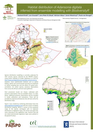
- 1. Habitat distribution of Adansonia digitata inferred from ensemble modelling with BiodiversityR Species distribution modelling is currently underway for 150+ priority species selected by the PATSPO project, using similar methods of model calibrations as used for http://www.worldagroforestry.org/atlas-central-america. However, more sophisticated methods such as spatial folding, spatial and environmental thinning are employed to reduce sampling bias and the effects of spatial auto- correlation. For native species, presence observations from across the African continent were gathered. Here provisional results are shown, calibrated with presence observations that are available online. In a later phase, additional presence observations will be included in model calibrations and evaluations. These will be provided by experienced botanists that will also verify the distribution maps. Figure 1 was created by combining information from the www.vegetationmap4africa.org with the results of habitat distribution mapping. Where a section of the projected range of the species overlapped with its expected distribution in vegetation types, the section was given the same colouring as the vegetation map. Sections that did not match documented vegetation types were plotted in the grey33 R colour. Figure 1. Projected presence distribution of the species in Ethiopia. Administrative boundaries from www.gadm.org version 3.6. Figure 2. Administrative boundaries for Ethiopia from www.gadm.org version 3.6. Figure 3. Distribution of potential natural vegetation types in Ethiopia from www.vegetationmap4africa.org Figure 4. Projected presence distribution of the species across Africa. Administrative boundaries tmap version 2.2 (Tennekes 2018). Roeland Kindt1, Lars Graudal12, Jens-Peter B Lillesø2, Abrham Abiyu1, Soren Moestrup12, Paulo van Breugel3 1 World Agroforestry Centre, Tree Productivity and Diversity 2 University of Copenhagen, Department of Geosciences and Natural Resource Management (IGN) 3 HAS University of Applied Sciences, 's-Hertogenbosch
- 2. Habitat distribution of Afrocarpus falcatus inferred from ensemble modelling with BiodiversityR Species distribution modelling is currently underway for 150+ priority species selected by the PATSPO project, using similar methods of model calibrations as used for http://www.worldagroforestry.org/atlas-central-america. However, more sophisticated methods such as spatial folding, spatial and environmental thinning are employed to reduce sampling bias and the effects of spatial auto- correlation. For native species, presence observations from across the African continent were gathered. Here provisional results are shown, calibrated with presence observations that are available online. In a later phase, additional presence observations will be included in model calibrations and evaluations. These will be provided by experienced botanists that will also verify the distribution maps. Figure 1 was created by combining information from the www.vegetationmap4africa.org with the results of habitat distribution mapping. Where a section of the projected range of the species overlapped with its expected distribution in vegetation types, the section was given the same colouring as the vegetation map. Sections that did not match documented vegetation types were plotted in the grey33 R colour. Roeland Kindt1, Lars Graudal12, Jens-Peter B Lillesø2, Abrham Abiyu1, Soren Moestrup12 1 World Agroforestry Centre, Tree Productivity and Diversity 2 University of Copenhagen, Department of Geosciences and Natural Resource Management (IGN) Figure 1. Projected presence distribution of the species in Ethiopia. Administrative boundaries from www.gadm.org version 3.6. Figure 2. Administrative boundaries for Ethiopia from www.gadm.org version 3.6. Figure 3. Distribution of potential natural vegetation types in Ethiopia from www.vegetationmap4africa.org Figure 4. Projected presence distribution of the species across Africa. Administrative boundaries tmap version 2.2 (Tennekes 2018).
- 3. Habitat distribution of Balanites aegyptiaca inferred from ensemble modelling with BiodiversityR Species distribution modelling is currently underway for 150+ priority species selected by the PATSPO project, using similar methods of model calibrations as used for http://www.worldagroforestry.org/atlas-central-america. However, more sophisticated methods such as spatial folding, spatial and environmental thinning are employed to reduce sampling bias and the effects of spatial auto- correlation. For native species, presence observations from across the African continent were gathered. Here provisional results are shown, calibrated with presence observations that are available online. In a later phase, additional presence observations will be included in model calibrations and evaluations. These will be provided by experienced botanists that will also verify the distribution maps. Figure 1 was created by combining information from the www.vegetationmap4africa.org with the results of habitat distribution mapping. Where a section of the projected range of the species overlapped with its expected distribution in vegetation types, the section was given the same colouring as the vegetation map. Sections that did not match documented vegetation types were plotted in the grey33 R colour. Figure 1. Projected presence distribution of the species in Ethiopia. Administrative boundaries from www.gadm.org version 3.6. Figure 2. Administrative boundaries for Ethiopia from www.gadm.org version 3.6. Figure 3. Distribution of potential natural vegetation types in Ethiopia from www.vegetationmap4africa.org Figure 4. Projected presence distribution of the species across Africa. Administrative boundaries tmap version 2.2 (Tennekes 2018). Roeland Kindt1, Lars Graudal12, Jens-Peter B Lillesø2, Abrham Abiyu1, Soren Moestrup12, Paulo van Breugel3 1 World Agroforestry Centre, Tree Productivity and Diversity 2 University of Copenhagen, Department of Geosciences and Natural Resource Management (IGN) 3 HAS University of Applied Sciences, 's-Hertogenbosch
- 4. Habitat distribution of Cordia africana inferred from ensemble modelling with BiodiversityR Species distribution modelling is currently underway for 150+ priority species selected by the PATSPO project, using similar methods of model calibrations as used for http://www.worldagroforestry.org/atlas-central-america. However, more sophisticated methods such as spatial folding, spatial and environmental thinning are employed to reduce sampling bias and the effects of spatial auto- correlation. For native species, presence observations from across the African continent were gathered. Here provisional results are shown, calibrated with presence observations that are available online. In a later phase, additional presence observations will be included in model calibrations and evaluations. These will be provided by experienced botanists that will also verify the distribution maps. Figure 1 was created by combining information from the www.vegetationmap4africa.org with the results of habitat distribution mapping. Where a section of the projected range of the species overlapped with its expected distribution in vegetation types, the section was given the same colouring as the vegetation map. Sections that did not match documented vegetation types were plotted in the grey33 R colour. Roeland Kindt1, Lars Graudal12, Jens-Peter B Lillesø2, Abrham Abiyu1, Soren Moestrup12 1 World Agroforestry Centre, Tree Productivity and Diversity 2 University of Copenhagen, Department of Geosciences and Natural Resource Management (IGN) Figure 1. Projected presence distribution of the species in Ethiopia. Administrative boundaries from www.gadm.org version 3.6. Figure 2. Administrative boundaries for Ethiopia from www.gadm.org version 3.6. Figure 3. Distribution of potential natural vegetation types in Ethiopia from www.vegetationmap4africa.org Figure 4. Projected presence distribution of the species across Africa. Administrative boundaries tmap version 2.2 (Tennekes 2018).
- 5. Habitat distribution of Faidherbia albida inferred from ensemble modelling with BiodiversityR Species distribution modelling is currently underway for 150+ priority species selected by the PATSPO project, using similar methods of model calibrations as used for http://www.worldagroforestry.org/atlas-central-america. However, more sophisticated methods such as spatial folding, spatial and environmental thinning are employed to reduce sampling bias and the effects of spatial auto- correlation. For native species, presence observations from across the African continent were gathered. Here provisional results are shown, calibrated with presence observations that are available online. In a later phase, additional presence observations will be included in model calibrations and evaluations. These will be provided by experienced botanists that will also verify the distribution maps. Figure 1 was created by combining information from the www.vegetationmap4africa.org with the results of habitat distribution mapping. Where a section of the projected range of the species overlapped with its expected distribution in vegetation types, the section was given the same colouring as the vegetation map. Sections that did not match documented vegetation types were plotted in the grey33 R colour. Roeland Kindt1, Lars Graudal12, Jens-Peter B Lillesø2, Abrham Abiyu1, Soren Moestrup12 1 World Agroforestry Centre, Tree Productivity and Diversity 2 University of Copenhagen, Department of Geosciences and Natural Resource Management (IGN) Figure 1. Projected presence distribution of the species in Ethiopia. Administrative boundaries from www.gadm.org version 3.6. Figure 2. Administrative boundaries for Ethiopia from www.gadm.org version 3.6. Figure 3. Distribution of potential natural vegetation types in Ethiopia from www.vegetationmap4africa.org Figure 4. Projected presence distribution of the species across Africa. Administrative boundaries tmap version 2.2 (Tennekes 2018).
- 6. Habitat distribution of Hagenia abyssinica inferred from ensemble modelling with BiodiversityR Species distribution modelling is currently underway for 150+ priority species selected by the PATSPO project, using similar methods of model calibrations as used for http://www.worldagroforestry.org/atlas-central-america. However, more sophisticated methods such as spatial folding, spatial and environmental thinning are employed to reduce sampling bias and the effects of spatial auto- correlation. For native species, presence observations from across the African continent were gathered. Here provisional results are shown, calibrated with presence observations that are available online. In a later phase, additional presence observations will be included in model calibrations and evaluations. These will be provided by experienced botanists that will also verify the distribution maps. Figure 1 was created by combining information from the www.vegetationmap4africa.org with the results of habitat distribution mapping. Where a section of the projected range of the species overlapped with its expected distribution in vegetation types, the section was given the same colouring as the vegetation map. Sections that did not match documented vegetation types were plotted in the grey33 R colour. Roeland Kindt1, Lars Graudal12, Jens-Peter B Lillesø2, Abrham Abiyu1, Soren Moestrup12 1 World Agroforestry Centre, Tree Productivity and Diversity 2 University of Copenhagen, Department of Geosciences and Natural Resource Management (IGN) Figure 1. Projected presence distribution of the species in Ethiopia. Administrative boundaries from www.gadm.org version 3.6. Figure 2. Administrative boundaries for Ethiopia from www.gadm.org version 3.6. Figure 3. Distribution of potential natural vegetation types in Ethiopia from www.vegetationmap4africa.org Figure 4. Projected presence distribution of the species across Africa. Administrative boundaries tmap version 2.2 (Tennekes 2018).
- 7. Habitat distribution of Juniperus procera inferred from ensemble modelling with BiodiversityR Species distribution modelling is currently underway for 150+ priority species selected by the PATSPO project, using similar methods of model calibrations as used for http://www.worldagroforestry.org/atlas-central-america. However, more sophisticated methods such as spatial folding, spatial and environmental thinning are employed to reduce sampling bias and the effects of spatial auto- correlation. For native species, presence observations from across the African continent were gathered. Here provisional results are shown, calibrated with presence observations that are available online. In a later phase, additional presence observations will be included in model calibrations and evaluations. These will be provided by experienced botanists that will also verify the distribution maps. Figure 1 was created by combining information from the www.vegetationmap4africa.org with the results of habitat distribution mapping. Where a section of the projected range of the species overlapped with its expected distribution in vegetation types, the section was given the same colouring as the vegetation map. Sections that did not match documented vegetation types were plotted in the grey33 R colour. Roeland Kindt1, Lars Graudal12, Jens-Peter B Lillesø2, Abrham Abiyu1, Soren Moestrup12 1 World Agroforestry Centre, Tree Productivity and Diversity 2 University of Copenhagen, Department of Geosciences and Natural Resource Management (IGN) Figure 1. Projected presence distribution of the species in Ethiopia. Administrative boundaries from www.gadm.org version 3.6. Figure 2. Administrative boundaries for Ethiopia from www.gadm.org version 3.6. Figure 3. Distribution of potential natural vegetation types in Ethiopia from www.vegetationmap4africa.org Figure 4. Projected presence distribution of the species across Africa. Administrative boundaries tmap version 2.2 (Tennekes 2018).
- 8. Habitat distribution of Tamarindus indica inferred from ensemble modelling with BiodiversityR Species distribution modelling is currently underway for 150+ priority species selected by the PATSPO project, using similar methods of model calibrations as used for http://www.worldagroforestry.org/atlas-central-america. However, more sophisticated methods such as spatial folding, spatial and environmental thinning are employed to reduce sampling bias and the effects of spatial auto- correlation. For native species, presence observations from across the African continent were gathered. Here provisional results are shown, calibrated with presence observations that are available online. In a later phase, additional presence observations will be included in model calibrations and evaluations. These will be provided by experienced botanists that will also verify the distribution maps. Figure 1 was created by combining information from the www.vegetationmap4africa.org with the results of habitat distribution mapping. Where a section of the projected range of the species overlapped with its expected distribution in vegetation types, the section was given the same colouring as the vegetation map. Sections that did not match documented vegetation types were plotted in the grey33 R colour. Figure 1. Projected presence distribution of the species in Ethiopia. Administrative boundaries from www.gadm.org version 3.6. Figure 2. Administrative boundaries for Ethiopia from www.gadm.org version 3.6. Figure 3. Distribution of potential natural vegetation types in Ethiopia from www.vegetationmap4africa.org Figure 4. Projected presence distribution of the species across Africa. Administrative boundaries tmap version 2.2 (Tennekes 2018). Roeland Kindt1, Lars Graudal12, Jens-Peter B Lillesø2, Abrham Abiyu1, Soren Moestrup12, Paulo van Breugel3 1 World Agroforestry Centre, Tree Productivity and Diversity 2 University of Copenhagen, Department of Geosciences and Natural Resource Management (IGN) 3 HAS University of Applied Sciences, 's-Hertogenbosch
- 9. Habitat distribution of Ziziphus jujuba inferred from ensemble modelling with BiodiversityR Species distribution modelling is currently underway for 150+ priority species selected by the PATSPO project, using similar methods of model calibrations as used for http://www.worldagroforestry.org/atlas-central-america. However, more sophisticated methods such as spatial folding, spatial and environmental thinning are employed to reduce sampling bias and the effects of spatial auto- correlation. For native species, presence observations from across the African continent were gathered. Here provisional results are shown, calibrated with presence observations that are available online. In a later phase, additional presence observations will be included in model calibrations and evaluations. These will be provided by experienced botanists that will also verify the distribution maps. Figure 1 was created by combining information from the www.vegetationmap4africa.org with the results of habitat distribution mapping. Where a section of the projected range of the species overlapped with its expected distribution in vegetation types, the section was given the same colouring as the vegetation map. Sections that did not match documented vegetation types were plotted in the grey33 R colour. Roeland Kindt1, Lars Graudal12, Jens-Peter B Lillesø2, Abrham Abiyu1, Soren Moestrup12 1 World Agroforestry Centre, Tree Productivity and Diversity 2 University of Copenhagen, Department of Geosciences and Natural Resource Management (IGN) Figure 1. Projected presence distribution of the species in Ethiopia. Administrative boundaries from www.gadm.org version 3.6. Figure 2. Administrative boundaries for Ethiopia from www.gadm.org version 3.6. Figure 3. Distribution of potential natural vegetation types in Ethiopia from www.vegetationmap4africa.org Figure 4. Projected presence distribution of the species across Africa. Administrative boundaries tmap version 2.2 (Tennekes 2018).