Finding fault in Hollister, California
•Download as PPTX, PDF•
3 likes•838 views

We’re going to be looking at strike-slip (or transform) (OK sideways!) faults and at one specific example in particular – the Calaveras Fault in Central California. We’re going to find this fault and then follow its trace in Hollister, California. We then go in search of the big picture. Enjoy!

Recommended
More Related Content
Viewers also liked
Viewers also liked (19)
More from Alan Doherty
More from Alan Doherty (20)
Recently uploaded
Recently uploaded (20)
Editor's Notes
- Whet their appetite by starting here. We’re going to be looking at slip-strike faults and at one specific example in particular – the Calaveras Fault in Central California. We’re going to find this fault and then follow its trace in Hollister, California.
- Hollister sits in a wide valley between the Diablo Range of hills to the east and the Hollister Hills to the west.
- Hollister is a city in and the county seat of San Benito County, California, United States. The population was 34,928 at the 2010 census. Hollister is primarily an agricultural town. Hollister is one of at least three California towns claiming the title of "Earthquake Capital of the World" as well as the Hay Capitol of the World, the home of the California Gem Benitoite, the most legged centipede in the world, home to Pinnacles National Monument and the town based on the Wild One, the two others being Coalinga and Parkfield.
- Hollister, though is one of the best examples of aseismic creep in the world. You have to get your “eye” in though. I wonder why the roof of City hall is bowed like that?
- We start at 359 Locust Avenue – a neat little bungalow where something isn’t quite right. Can you spot what’s wrong or slightly off?
- Yup! If we could go back in time…. We could try to centre things on the porch. (Difficult as the porch doesn’t seem to be exactly at right angles to the main part of the building!)
- There is also a crack on the first step up to the porch so its not just the front path which is being affected. Indeed, this is a simplification for illustrative purposes. The line of the fault is more diagonal than the one shown. Move it a couple of feet towards you on the left and a couple of feet further away on the right and that would be about perfect! Let the kids point this out (which they do when you show them the map later). It’s a good way of spotting who is awake.
- Still the house seems safe. At least three houses have had to be demolished so far. They do appear to be allowing rebuilds as only one large gap site appears on Google Earth along the line of the fault.
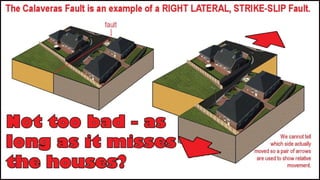
- The big question here is how did the developers and planners miss such an obvious fault. Were there no offset fences or lines of trees in this area to warn them of the creeping danger below? Explain right lateral and left lateral here. Use the analogy of two moving conveyors, side by side, moving in opposite directions. Switch one of them off. Does anything change? Remember relative movement is not the same as actual movement.
- Wooden structures actually stand up quite well to movement. They often can “raft” on top of land movement below. Concrete and brick structures always fare badly.
- This extension has got plastic cladding to accommodate the moving fault. But every so often, its going to mean a rebuild.
- If the concrete structure is big enough and is reinforced, it will often move as one piece.
- The fault appears to go right under this house on the corner of Locust Ave., and 4th Street. A bit “shoogly” but so far so good.
- An open question but the kids can get close to the right answer. They just need a little more input.
- The creep rate on the Calaveras fault has been measured at between 0.25 and 0.6inches (0.7 and 1.5cms) per year since 1910. So if the kids get an answer in that range – they are spot on. Really good little thought provoker this one. Ignore the questions (do we take the curve into consideration? etc.) and let them get on with it.
- 5th Street. Can you spot the fault? A bit harder this one but they should get it in the fence area at least.
- The north side of sixth Street. The pavement has been repaired on several occasions. The disruption zone is wider than before and the west side of the fault is higher than the eastern side. There were probably a lot of little scarps like this before the developers prepared the land for building.
- Looking across Dunne Memorial Park. The Calaveras fault trace here is a subtle vertical offset that runs north-south through the middle of the park. The eastern side of the fault is now higher than the western side! And I have no idea what is happening in the foreground. But if we wait a few years, we’ll find out!
- Summary map. If the kids have laptops, now is a good time to fire up Google Earth and follow the trace of the fault. Gap sites are worth looking for. There are also additional photos on Panoramio. The ones to the north are accurately positioned but the ones to the south around Dunne Memorial Park and 6th Street are not really helpful as half of them are in the wrong position. A few of the kerb breaks show up on Google so it is well worth a visit.
- So, back to the title page. Let’s put the Calaveras Fault in context. Any sign of fault traces on this map?
- The Calaveras Fault is part of the San Andreas Fault Zone.
- http://www.quake.ca.gov/gmaps/FAM/faultactivitymap.htmlAnd of course, the San Andreas is famous as the boundary between the North American Plate and the Pacific Plate. This fault hasn’t always sliced through California. There was no San Andreas Fault until about 16 million years ago. It was generated by pressure from the collision of the Farallon Plate – a plate which has almost disappeared – and the North American Plate which is still moving westwards after the break up of Pangea 200 million years ago. The sea floor spreadin centre between the Farallon Plate and the Pacific Plate was overrun by the North American Plate about 28 million years ago and subduction movement was gradually replaced by strike-slip movement, initially along those older faults to the west of the San Andreas Fault and then finally by huge fault positioned on the plate boundaries. The San Andreas accommodates the pressure between two plates by allowing movement between them. And in the last 16 million years there has been a lot of movement! How can we prove this?
- Well, just south of Hollister there is an interesting geological area called Pinnacles National Monument.
- And for the really big picture we must look at the whole of the west coast of North America. Here we can see that the San Andreas strike slip zone is an under land boundary between two plates. Oceanic spreading centres continues to accommodate strike slip movement to the south as the San Andreas peters out near the Salton Sea.It is easy to imagine that this spreading centre has been subducted under the north American Plate and that it may be responsible for the rifting which has created the basin and range topography of the South West. To the north the last fragments of the Farallon Plate are being subducted off the coast, fuelling the intermittant pyrotechnics of the Cascade Range of volcanoes. The subduction of the Farallon Plate has been responsible for the Sierra Nevada granite, the growth of the Rocky Mountains and the rise of the Colorado Plateau. It is also responsible for transporting old island arcs and various fragments of continental crustal material from other distant plates and accreting them to the North American Plate. Much of western North America is made up of these accreted “terranes”. I don’t think that the Farallon Plate is finished with the West Coast yet! What happens next?