Principles of remote sensing
•Télécharger en tant que PPTX, PDF•
89 j'aime•67,454 vues

Principles of remote sensing

Recommandé
Contenu connexe
Tendances
Tendances (20)
Similaire à Principles of remote sensing
Similaire à Principles of remote sensing (20)
Plus de Pramoda Raj
Plus de Pramoda Raj (20)
Dernier
Dernier (20)
Principles of remote sensing
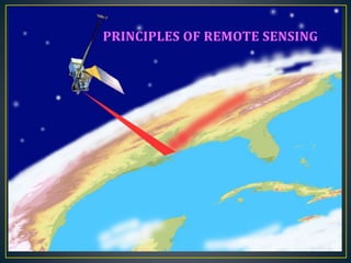
- 1. PRINCIPLES OF REMOTE SENSING
- 2. • “The art, science, and technology of obtaining reliable information about physical objects and the environment, through the process of recording, measuring and interpreting imagery and digital representations of energy patterns derived from non-contact sensor systems”. • According to India’s National Remote Sensing Agency- “Remote Sensing is the technique of acquiring information about objects on the earth’s surface without physically coming into contact with them”. INTRODUCTION TO REMOTE SENSING
- 3. History of Remote Sensing 1859 - First aerial photographer 1862 – US Army balloon corp 1903 - The Bavarian Pigeon Corps 1908 - First photos from an airplane 1914-1918 – World War I IGARSS 2013
- 4. • Detection and discrimination of objects or surface features means detecting and recording of radiant energy reflected or emitted by objects or surface. • Different objects return different amount of energy in different bands of the electromagnetic spectrum, incident upon it. • Depend upon the property of material (physical, structural, and chemical), surface roughness, angle of incidence , intensity , and wavelength of radiant energy.
- 5. 1. Energy Source or Illumination (A) 2. Radiation and the Atmosphere (B) 3. Interaction with the Target (C) 4. Recording of Energy by the Sensor (D) 5. Transmission, Reception, and Processing (E) 6. Interpretation and Analysis (F) 7. Application (G)
- 6. The first requirement for remote sensing is to have an energy source to illuminate the target (unless the sensed energy is being emitted by the target). This energy is in the form of electromagnetic radiation.
- 7. Electromagnetic radiation is the energy source to illuminate the target. • Electromagnetic wave is consists of two fluctuating fields, they are an electrical field (E) and a magnetic field (M). These two fluctuate at right angle to one another, and both are perpendicular to the direction of propagation. • Relation between Wavelength and Frequency: Wavelength and frequency are related by the following formula: c = λv where: λ = wavelength (m) v = frequency (cycles per second, Hz) c = speed of light (3x10⁸ m/s) 1. Medium frequency - 2. High frequency - shorter wavelength 3. Low frequency - Higher wavelength Wavelength
- 8. ElectromagneticSpectrum The Electromagnetic spectrum is the continuum of energy ranging from kilometers to nanometers in wavelength. This continuum is commonly divided into the following ranges, called spectral bands, the boundaries between them being gradational.
- 9. • As the energy travels from its source to the target, it will come in contact with and interact with the atmosphere it passes through. • These effects are caused by the mechanisms of scattering and absorption • Scattering occurs when particles or large gas molecules present in the atmosphere interact with and cause the electromagnetic radiation to be redirected from its original path. • How much scattering takes place depends on several factors including the wavelength of the radiation, the abundance of particles or gases, and the distance the radiation travels through the atmosphere. There are three (3) types of scattering which take place:
- 10. Rayleigh scattering occurs when particles are very small compared to the wavelength of the radiation, e.g. small specks of dust or nitrogen and oxygen molecules. Rayleigh scattering causes shorter wavelengths of energy to be scattered much more than longer wavelengths. This is the dominant scattering mechanism in the upper atmosphere.
- 11. Mie scattering occurs when the particles are just about the same size as the wavelength of the radiation. Dust, pollen, smoke and water vapour are common causes of Mie scattering which tends to affect longer wavelengths than those affected by Rayleigh scattering. Mie scattering occurs mostly in the lower portions of the atmosphere where larger particles are more abundant,
- 12. This occurs when the particles are much larger than the wavelength of the radiation. Water droplets and large dust particles can cause this type of scattering. Nonselective scattering gets its name from the fact that all wavelengths are scattered about equally. This type of scattering causes fog and clouds to appear white to our eyes because blue, green, and red light are all scattered in approximately equal quantities (blue+green+red light = white light).
- 13. Absorption is the other main mechanism at work when electromagnetic radiation interacts with the atmosphere. This phenomenon causes molecules in the atmosphere to absorb energy at various wavelengths. Ozone, carbon dioxide, and water vapour are the three main atmospheric constituents which absorb radiation.
- 14. • Those areas of the frequency spectrum which are not severely influenced by atmospheric absorption and thus, are useful to remote sensors, are called atmospheric windows. • One important practical consequence of the interaction of electromagnetic radiation with matter and of the detailed composition of our atmosphere is that only light in certain wavelength regions can penetrate the atmosphere well. • Because gases absorb electromagnetic energy in very specific regions of the spectrum, they influence where (in the spectrum) we can "look"
- 15. Radiation that is not absorbed or scattered in the atmosphere can reach and interact with the Earth's surface. There are three forms of interaction that can take place when energy strikes, or is incident (I) upon the surface:
- 16. Absorption (A) occurs when radiation (energy) is absorbed into the target. Transmission (T) occurs when radiation passes through a target. Reflection (R) occurs when radiation "bounces" off the target and is redirected.
- 17. When a surface is smooth, we get specular or mirror-like reflection where all (or almost all) of the energy is directed away from the surface in a single direction. Diffuse reflection occurs when the surface is rough and the energy is reflected almost uniformly in all directions. specular diffuse
- 18. • After the energy has been scattered by, or emitted from the target, we require a sensor (remote - not in contact with the target) to collect and record the electromagnetic radiation.
- 19. • The energy recorded by the sensor has to be transmitted, often in electronic form, to a receiving and processing station where the data are processed into an image (hardcopy and/or digital).
- 20. • the processed image is interpreted, visually and/or digitally or electronically, to extract information about the target which was illuminated.
- 21. • Geology: geological mapping; • Hydrology: monitoring wetlands and snow cover; • Agriculture: crop type identification, crop condition monitoring, soil moisture measurement, and soil tillage and crop residue identification; • Forestry: clear-cuts and linear features mapping, biomass estimation, species identification and fire scar mapping; • Oceanography: sea ice identification, coastal wind field measurement, and wave slope measurement. • Shipping: for ship detection and classification. • Coastal Zone: for shoreline detection, substrate mapping, slick detection and general vegetation mapping. • Military/Security Applications: detecting or locating metal objects.
- 22. • surficial deposit / bedrock mapping • lithological mapping • structural mapping • sand and gravel (aggregate) exploration/ exploitation • mineral exploration • hydrocarbon exploration • environmental geology • geobotany • baseline infrastructure • sedimentation mapping and monitoring • event mapping and monitoring • geo-hazard mapping • planetary mapping
- 23. • wetlands mapping and monitoring, • soil moisture estimation, • snow pack monitoring / delineation of extent, • measuring snow thickness, • determining snow-water equivalent, • river and lake ice monitoring, • flood mapping and monitoring, • river /delta change detection • drainage basin mapping and watershed modeling • irrigation canal leakage detection • irrigation scheduling
- 24. . ice concentration · ice type / age /motion · surface topography · tactical identification of leads: navigation: safe shipping routes/rescue · ice condition (state of decay) · pollution monitoring · meteorological / global change research
- 25. • natural resource management • · · baseline mapping for GIS input • · urban expansion / encroachment • · routing and logistics planning for seismic / exploration / resource extraction activities • · damage delineation (tornadoes, flooding, volcanic, seismic, fire) • · legal boundaries for tax and property evaluation • · target detection - identification of landing strips, roads, clearings, bridges, • land/water interface
- 26. Ocean pattern identification: · wind and wave retrieval · water temperature monitoring · water quality ·Oil spill mapping and predicting oil spill extent and drift strategic support for oil spill emergency response decisions · identification of natural oil seepage areas for exploration Shipping · navigation routing · traffic density studies · near-shore bathymetry mapping
- 27. Remote sensing technology has developed from balloon photography to aerial photography & then advanced to multi-spectral satellite imaging. Radiation interaction characteristics of earth and atmosphere in different regions of Electromagnetic spectrum are very useful for identifying and characterizing earth and atmospheric features. Aircrafts and satellites are the main platforms used in the remote sensing. For measurements of the Earth's surface and depending on the wavelength region examined, these properties can include factors such as roughness, mineralogy, temperature, particle size, and elemental abundance. Remote sensing has become a widely accepted research tool by almost all Geological Surveys the world over. CONCLUSION
- 28. BOOKS • Anji Reddy. M., (2001) Remote Sensing and Geographical information Systems, Third Edition, BS. Publications, Hyderabad.,Pp:24-54. • Floyd F. Sabins.,(1996/1997) Remote Sensing principles and Interpretation., W.H. Freeman And Company New york 3rd Edition., Pp:29-236. WEB SITES • http://rst.gsfc.nasa.gov • http://www.nrcan.gc.ca/sites/www.nrcan.gc.ca.earth- sciences/files/pdf/resource/tutor/fundam/pdf/fundamentals _e.pdf • http://geography.huji.ac.il/personal/Noam%20Levin/1999- fundamentals-of-remote-sensing.pdf
- 29. Thank Q ? RESOURCESAT-1 RISAT-1 CartoSat-2B GSAT-8 Resource sat–2
Notes de l'éditeur
- The wavelength is the length of one wave cycle, which can be measured as the distance between successive wave crests. Wavelength is usually represented by the Greek letter lambda (λ). Wavelength is measured in metres (m) or some factor of metres such as nanometres (nm, 10-9 metres), micrometres (μm, 10-6 metres) (μm, 10-6 metres) or centimetres (cm, 10-2 metres). Frequency refers to the number of cycles of a wave passing a fixed point per unit of time. Frequency is normally measured in hertz (Hz), equivalent to one cycle per second, and various multiples of hertz.
- In remote sensing, we are most interested in measuring the radiation reflected from targets. We refer to two types of reflection, which represent the two extreme ends of the way in which energy is reflected from a target: specular reflection and diffuse reflection.
- Discuss about active sensors and passive sensors