Environmental Impact Assessment (EIA) report on Rampal 1320MW coal-based power plant near the Sundarbans mangroves
•
32 j'aime•43,333 vues

The Department of Environment has approved this faulty EIA submitted by the Power Development Board. The project would be implemented by the governments of Bangladesh and India.

Recommandé
Recommandé
Contenu connexe
Tendances
Tendances (20)
En vedette
En vedette (10)
Similaire à Environmental Impact Assessment (EIA) report on Rampal 1320MW coal-based power plant near the Sundarbans mangroves
Similaire à Environmental Impact Assessment (EIA) report on Rampal 1320MW coal-based power plant near the Sundarbans mangroves (20)
Plus de Probir Bidhan
Plus de Probir Bidhan (10)
Dernier
Dernier (12)
Environmental Impact Assessment (EIA) report on Rampal 1320MW coal-based power plant near the Sundarbans mangroves
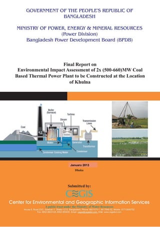
- 3. GOVERNMENT OF THE PEOPLE’S REPUBLIC OF BANGLADESH MINISTRY OF POWER, ENERGY & MINERAL RESOURCES POWER DIVISION BANGLADESH POWER DEVELOPMENT BOARD Final Report on Environmental Impact Assessment of 2x (500-660) MW Coal Based Thermal Power Plant to be Constructed at the Location of Khulna Dhaka January 2013 Center for Environmental and Geographic Information Services A public trust under the Ministry of Water Resources
- 5. iv Acknowledgement The Center for Environmental and Geographic Information Services (CEGIS), a Public Trust under the Ministry of Water Resources, is grateful to Bangladesh Power Development Board (BPDB) for awarding the contract for rendering consultancy services under the caption of “Initial Environmental Examination (IEE) and Environmental Impact Assessment (EIA) of 2 × (500-660) MW Coal Based Power Plant to be constructed at the location of Khulna” to CEGIS. CEGIS greatly acknowledges the visionary thinking provided by Dr. Towfiq-e-Elahi Chowdhury, BB, Honorable Advisor to the Honorable Prime Minister, People’s Republic of Bangladesh and Mr. Muhammad Enamul Huq, MP, Honorable State Minister, Ministry of Power, Energy and Mineral Resources for their valuable guidance and constructive comments on the study plan and approach. CEGIS is also grateful to Mr. Md Abul Kalam Azad, Former Secretary, Power Division, the Ministry of Power, Energy and Mineral Resources (MoPEMR) and Dr. Moowar Islam, Secretary, Power Division, MoPEMR for their continuous guidance. CEGIS is also grateful to Mr. A S M Alamgir Kabir, Former Chairman, BPDB, and Md. Abdul Wahab Khan Chairman, BPDB for their informative instructions in different stages of the study. CEGIS is gratefully indebted to Mr. Md. Abul Quasem, Member (Company Affairs), BPDB for his continuous support and suggestions during execution of this study. CEGIS is cordially acknowledge to Late Mr. Md. Naimul Hossain, Former Project Director, and Md. Abdur Razzak, Project Director, Chittagong and Khulna 2x 1320 MW coal based thermal power plant construction project of BPDB for his guidance and endless support. CEGIS also highly admires the support and cooperation received from Mr Abdul Latif Khan P. Eng., and Mr. Md Mustafizur Rahman, Superintending Engineer, Chittagong and Khulna 2x 1320 MW coal based thermal power plant construction project of BPDB and Mr Minhaj Uddin Ahmed, Director, Civil Works, BPDB. The CEGIS team is also indebted to Executive Engineers, Chittagong and Khulna 2x 1320 MW coal based thermal power plant construction project of BPDB. CEGIS is thankful to Mr. Khandaker Azizur Rahman, Consultant, BPDB for his cooperation, guidance and support to the study team. CEGIS is thankful to the National Thermal Power Plant Company (NTPC) Ltd., India, the Feasibility study team of the same project for their continuous advice and sharing the conceptual understanding on coal fired power plant in developing project description, support in idea generation and spending their valuable time in CEGIS. CEGIS also gratefully acknowledges the facilitation and supports of Mr. Md. Akram Hossain, Deputy Commissioner, Bagerhat, Mr. Md. Delwar Haider, Additional Deputy Commissioner (Revenue), Bagerhat and other officials for their suggestions in familiarizing the team members on land acquisition process and other legal issues of the same. Chairman of the concerned Upazila and unions as well as other people representatives of the project area
- 6. v also deserve special appreciation for their support at different stages in conducting the study. The members of the study team also acknowledge the guidance and support of the officials received from of DoE, Dhaka and DoE, Khulna; Mongla Port Authority; BWDB, Khulna; DPHE, Khulna, Civil Surgeon, Rampal Upazila Health Complex; DAE, Rampal; DoF, Rampal and others while conducting the reconnaissance survey.
- 7. vi Table of Contents Acknowledgement.........................................................................................................iv Table of Contents ..........................................................................................................vi Abbreviations and Acronyms .....................................................................................xxii Glossary......................................................................................................................xxv Unit Conversion Table .............................................................................................. xxvii Chapter 1 : Introduction ................................................................................................1 1.1 Background.......................................................................................................1 1.2 Purpose of the study..........................................................................................6 1.3 Need of the Project............................................................................................6 1.4 Importance of the Project ..................................................................................7 1.5 Scope of the EIA study.......................................................................................7 1.6 Study limitations................................................................................................8 1.7 EIA team...........................................................................................................8 1.8 Report format..................................................................................................10 Chapter 2 : Policy, Legal and Administrative Framework............................................13 2.1 Applicable Policies and Legal Provision ..............................................................14 2.2 National Environmental Legal Provisions in Connection with Setup, Operation & Maintenance....................................................................................................15 2.2.1 Procedure to Obtain Environmental Clearance Certificate....................................16 2.2.2 Protected areas................................................................................................18 2.2.3 Effluent discharge ............................................................................................19 2.2.4 Stack Height ....................................................................................................20 2.2.5 Site location.....................................................................................................21 2.3 Compliance under the National Laws.................................................................21 2.3.1 The Forest Act, 1927 & Amendment Act 2000....................................................21 2.3.2 The Penal Code, 1860 ......................................................................................22 2.3.3 The Acquisition and Requisition of Immovable Property Ordinance (1982)...........22 2.3.4 The Protection and Conservation of Fish Act 1950..............................................22 2.3.5 Civil Aviation Ordinance 1960 & Civil Aviation Rules, 1984 ..................................23 2.3.6 Ports Act, 1908 ................................................................................................23 2.3.7 Mongla Port Authority Ordinance, 1976 .............................................................24 2.3.8 Environment Conservation Act (1995, Amended in 2000 & 2002)........................24 2.3.9 The Environment Conservation Rules, 1997 .......................................................25 2.3.10 The Environment Court Act, 2000 .....................................................................25 2.3.11 The Fatal Accidents Act, 1855 ...........................................................................26 2.3.12 The Dock Laborers Act, 1934 ............................................................................26 2.3.13 The Dangerous Cargoes Act, 1953 ....................................................................26 2.3.14 The Fire Services Ordinance 1959 .....................................................................26 2.3.15 The Bangladesh Petroleum Act, 1974 ................................................................27 2.3.16 The Explosives Act, 1884..................................................................................28 2.3.17 Wildlife Conservation (protection and safety) Act 2012 .......................................28 2.4 Policy Guidance ...............................................................................................29 2.4.1 National Environment Policy..............................................................................29 2.4.2 Draft Coal Policy...............................................................................................29 2.4.3 Power System Master Plan, 2010 ......................................................................30 2.4.4 National Environment Management Action Plan 1995 .........................................30 2.4.5 The National Forest Policy (1994)......................................................................30 2.4.6 The National Energy Policy (1995).....................................................................31
- 8. vii 2.4.7 The National Water Policy (1999)......................................................................31 2.4.8 World Bank’s Safeguards (Relevant Policies) ......................................................32 2.5 International Maritime Conventions, Protocols and Agreements applicable for coal transportation...........................................................................................41 2.6 International Legal Obligations .........................................................................44 2.6.1 Rio Declaration ................................................................................................44 2.6.2 Convention on Biological Diversity (1992) ..........................................................45 2.6.3 Convention on Wetlands of International Importance Especially as Waterfowl Habitat, Ramsar (1971)....................................................................................45 2.6.4 United Nations Convention on the Law of the Sea, Montego Bay, (1982) .............45 2.6.5 UNESCO World Heritage Convention..................................................................46 2.6.6 Development Agency’s Health and Safety Guidelines ..........................................46 2.6.7 Social Safeguard Policy of ADB and World Bank .................................................46 2.6.8 Compliance with World Bank Environmental Assessment (EA) Process.................47 Chapter 3 : Approach and Methodology ......................................................................49 3.1 Introduction ....................................................................................................49 3.2 Assumptions....................................................................................................51 3.3 Study area boundary........................................................................................51 3.4 Study period....................................................................................................51 3.5 Physical Environment Assessment.....................................................................54 3.6 Topographical survey and development of Digital Elevation Model ......................54 3.7 Soil Survey ......................................................................................................54 3.8 Air quality assessment .....................................................................................55 3.9 Water Resources .............................................................................................55 3.10 Land Resources ...............................................................................................60 3.11 Agricultural Resources......................................................................................61 3.12 Livestock Resources.........................................................................................61 3.13 Fisheries .........................................................................................................61 3.14 Ecosystems .....................................................................................................64 3.15 Socio-economic condition.................................................................................65 3.16 Impact Assessment and Evaluation...................................................................69 3.16.1 Assessment and evaluation...............................................................................69 3.16.2 Air pollutant dispersion modeling ......................................................................69 3.16.3 Identification of control measures for minimizing CO2, SO2, NO2, etc emission .....70 3.17 Risk and hazard analysis ..................................................................................70 3.18 Environmental management and monitoring plan ..............................................70 3.19 Resettlement and compensation.......................................................................70 Chapter 4 : Evaluation of Alternatives Site Selection.................................................71 4.1 Introduction ....................................................................................................71 4.2 Approach and methodology..............................................................................72 4.3 Alternative sites evaluation...............................................................................75 4.4 Concluding remarks on selected site .................................................................77 Chapter 5 : Project Description....................................................................................79 5.1 Project Proponent............................................................................................79 5.2 Project Concept ...............................................................................................79 5.3 Purpose of the Plant-intent...............................................................................79 5.4 Project Location...............................................................................................80 5.4.1 Topographical information ................................................................................80 5.4.2 Access way......................................................................................................81 5.4.3 Site development .............................................................................................86 5.5 Project layout ..................................................................................................93 5.6 Project Overview .............................................................................................94
- 9. viii 5.7 Land Requirement and Acquisition....................................................................96 5.8 Project activities ..............................................................................................97 5.9 Work Plan of Project Implementation................................................................97 5.10 Costing and Funding ........................................................................................97 5.11 Fuel Requirement ............................................................................................98 5.12 Water Requirement and Source ........................................................................98 5.13 Resources and Utility Demand ..........................................................................98 5.14 Process Description of Individual Project Components........................................98 5.14.1 Power Generation ............................................................................................98 5.14.2 Steam Generator and Auxiliaries .......................................................................99 5.14.3 Fuel Oil Burning System....................................................................................99 5.14.4 Coal Burning System ........................................................................................99 5.14.5 Soot Blowing System........................................................................................99 5.14.6 Electrostatic Precipitator ................................................................................. 100 5.14.7 Flue Gas Desulfurization System...................................................................... 100 5.14.8 Auxiliary Boiler............................................................................................... 100 5.14.9 Turbine and its auxiliaries ............................................................................... 102 5.14.10 Deaerator ...................................................................................................... 102 5.14.11 Coal handling and storage .............................................................................. 102 5.14.12 Fuel oil transport, unloading and storage......................................................... 105 5.14.13 Chimney ........................................................................................................ 105 5.14.14 Ash handling and transportation system .......................................................... 105 5.14.15 Ash slurry disposal system .............................................................................. 106 5.14.16 Cooling system............................................................................................... 107 5.15 Coal source and transportation system............................................................ 107 5.15.1 Coal specification and requirement.................................................................. 107 5.15.2 Coal sources .................................................................................................. 108 5.15.3 Coal transportation......................................................................................... 109 5.16 Water System and Management ..................................................................... 113 5.16.1 Source of water ............................................................................................. 113 5.16.2 Water consumption ........................................................................................ 113 5.16.3 Circulating and makeup water system ............................................................. 115 5.16.4 Water treatment system ................................................................................. 115 5.16.5 Miscellaneous water system............................................................................ 116 5.17 Civil structure and urban facilities ................................................................... 117 5.18 Electrical system............................................................................................ 118 5.18.1 Power evacuation........................................................................................... 118 5.18.2 Start-up power requirement............................................................................ 118 5.18.3 Auxiliary power supply scheme ....................................................................... 118 5.18.4 Generator ...................................................................................................... 118 5.18.5 High voltage switchyard and power distribution ............................................... 118 5.19 Central Control and Monitoring ....................................................................... 119 5.20 Project Design and Construction ..................................................................... 119 5.20.1 Design........................................................................................................... 119 5.20.2 Construction .................................................................................................. 119 5.21 Pollution Mitigation Measures ......................................................................... 120 5.21.1 Air pollution control system............................................................................. 120 5.21.2 Noise control.................................................................................................. 120 5.21.3 Intent of water reuse ..................................................................................... 120 5.21.4 Effluent treatment.......................................................................................... 120 5.21.5 Thermal pollution control................................................................................ 121
- 10. ix 5.21.6 Waste management ....................................................................................... 121 5.21.7 Water Intake Structure................................................................................... 121 5.22 Afforestation and greenbelt development ........................................................ 121 5.23 Rehabilitation and resettlement ...................................................................... 121 5.24 Post operation monitoring program................................................................. 122 Chapter 6 : Environmental and Social Baseline Condition.........................................123 6.1 Study Area .................................................................................................... 123 6.2 Availability of Coal ......................................................................................... 123 6.3 Availability of water ....................................................................................... 124 6.4 Physical Environment..................................................................................... 124 6.4.1 Climate and meteorology................................................................................ 124 6.4.2 Landscape and Topography ............................................................................ 134 6.4.3 Geology......................................................................................................... 147 6.4.4 Ambient air quality ......................................................................................... 149 6.4.5 Acoustic environment ..................................................................................... 152 6.4.6 Seismicity ...................................................................................................... 153 6.5 Surface Water Resources ............................................................................... 156 6.5.1 Surface water system..................................................................................... 156 6.5.2 Hydrology...................................................................................................... 157 6.5.3 Surface runoff during rain............................................................................... 158 6.5.4 Water Level ................................................................................................... 158 6.5.5 Tidal Behavior................................................................................................ 159 6.5.6 Tidal Inundation............................................................................................. 160 6.5.7 Waves ........................................................................................................... 161 6.5.8 River bed sediment ........................................................................................ 161 6.5.9 Aquatic monitoring......................................................................................... 161 6.5.10 Water quality ................................................................................................. 161 6.5.11 Water Use ..................................................................................................... 164 6.6 River Morphology........................................................................................... 166 6.6.1 River plan form .............................................................................................. 166 6.6.2 Erosion and accretion ..................................................................................... 168 6.6.3 River bathymetry ........................................................................................... 170 6.7 Groundwater Resources ................................................................................. 174 6.7.1 Hydrogeology ................................................................................................ 174 6.7.2 Groundwater level.......................................................................................... 176 6.7.3 Groundwater use ........................................................................................... 179 6.7.4 Groundwater quality....................................................................................... 179 6.8 Navigation..................................................................................................... 179 6.8.1 Navigation system.......................................................................................... 179 6.8.2 Aids to navigation .......................................................................................... 181 6.8.3 Mongla Port Facilities...................................................................................... 181 6.9 Transportation system ................................................................................... 182 6.9.1 Road communication system........................................................................... 182 6.9.2 Water communication..................................................................................... 184 6.9.3 Railway communication system....................................................................... 184 6.9.4 Air communication system .............................................................................. 184 6.10 Tropical Cyclones and Surges ......................................................................... 184 6.11 Maximum Historical Surge considered for Site Development ............................. 187 6.12 Land Resources ............................................................................................. 188 6.12.1 Agro ecological region .................................................................................... 188 6.12.2 Land Type ..................................................................................................... 189
- 11. x 6.12.3 Soil Texture ................................................................................................... 190 6.12.4 Soil quality..................................................................................................... 190 6.12.5 Land use ....................................................................................................... 191 6.13 Agriculture .................................................................................................... 193 6.13.1 Cropping Pattern............................................................................................ 193 6.13.2 Crop Calendar................................................................................................ 194 6.13.3 Crop production and damages ........................................................................ 194 6.13.4 Agricultural input use ..................................................................................... 196 6.13.5 Irrigation ....................................................................................................... 197 6.14 Livestock and Poultry ..................................................................................... 197 6.14.1 Feed and Fodder shortage .............................................................................. 198 6.14.2 Livestock/Poultry Diseases.............................................................................. 198 6.15 Fisheries ....................................................................................................... 198 6.15.2 Fish habitat.................................................................................................... 202 6.15.3 Fish production .............................................................................................. 204 6.15.4 Fish migration................................................................................................ 205 6.16 Shrimp fry Collection...................................................................................... 205 6.17 Plankton and Benthos/other microscopic invertebrates..................................... 206 6.18 Other Aquatic species .................................................................................... 206 6.19 Dolphin ......................................................................................................... 207 6.20 Ecosystem..................................................................................................... 208 6.20.1 Ecosystem habitats and biodiversity ................................................................ 209 6.20.2 Ecosystems of the study area ......................................................................... 209 6.20.3 Homestead forestation ................................................................................... 210 6.20.4 Roadside vegetation....................................................................................... 210 6.21 Bio-ecological zone ........................................................................................ 211 6.22 Biodiversity of Sundarbans ............................................................................. 218 6.23 Historical changes in Sundarbans vegetation ................................................... 221 6.24 Fisheries Resources of Sundarbans ................................................................. 224 6.24.1 Distribution of fisheries................................................................................... 224 6.24.2 Sundarbans as a fish habitat........................................................................... 225 6.24.3 Fish production .............................................................................................. 226 6.24.4 Fish composition ............................................................................................ 226 6.24.5 Sundarbans wild life sanctuary........................................................................ 227 6.24.6 Sundarbans conservation projects ................................................................... 232 6.25 Socio-economic condition............................................................................... 235 6.25.1 Settlement of urban and rural community........................................................ 235 6.25.2 Demographic profile ....................................................................................... 237 6.25.3 Polarization in land ownership......................................................................... 237 6.25.4 Employment opportunity and availability of manpower ..................................... 238 6.25.5 Education ...................................................................................................... 240 6.25.6 Occupational pattern ...................................................................................... 241 6.25.7 Demand of electricity...................................................................................... 242 6.25.8 Population migration ...................................................................................... 243 6.25.9 Communal diversity........................................................................................ 243 6.25.10 Vulnerability to natural disaster....................................................................... 244 6.25.11 Communication infrastructure ......................................................................... 244 6.25.12 Social solidarity .............................................................................................. 244 6.25.13 Safety nets .................................................................................................... 245 6.26 Climate Change Scenario................................................................................ 247 Chapter 7 : Important Environmental and Social Components.................................253
- 12. xi 7.1 Physical environment ..................................................................................... 253 7.1.1 Landscape and scenic beauty.......................................................................... 253 7.1.2 Heat radiation................................................................................................ 253 7.1.3 Air quality...................................................................................................... 253 7.1.4 Acid rain........................................................................................................ 253 7.1.5 Noise............................................................................................................. 254 7.1.6 Solid waste .................................................................................................... 254 7.2 Water Resources ........................................................................................... 254 7.2.1 Tidal inundation ............................................................................................. 254 7.2.2 Drainage congestion....................................................................................... 254 7.2.3 Water logging ................................................................................................ 254 7.2.4 Salinity intrusion ............................................................................................ 254 7.2.5 Erosion.......................................................................................................... 254 7.2.6 Accretion ....................................................................................................... 255 7.2.7 Surface water quality...................................................................................... 255 7.2.8 Ground water level and quality........................................................................ 255 7.3 Transportation system ................................................................................... 255 7.3.1 Communication.............................................................................................. 255 7.3.2 Traffic load on roads ...................................................................................... 255 7.3.3 Navigation/ River Traffic ................................................................................. 255 7.4 Land Resources ............................................................................................. 255 7.4.1 Land Type ..................................................................................................... 255 7.4.2 Land Use ....................................................................................................... 256 7.4.3 Soil nutrient status ......................................................................................... 256 7.4.4 Heavy metal .................................................................................................. 256 7.5 Agriculture .................................................................................................... 256 7.5.1 Loss of agricultural land.................................................................................. 256 7.5.2 Crop production ............................................................................................. 256 7.5.3 Crop damage ................................................................................................. 256 7.6 Livestock....................................................................................................... 256 7.6.1 Fodder and disease ........................................................................................ 256 7.7 Fisheries ....................................................................................................... 256 7.7.1 Fish Habitat ................................................................................................... 256 7.7.2 Fish Migration ................................................................................................ 257 7.7.3 Fish Biodiversity/Species Composition.............................................................. 257 7.7.4 Fish Production .............................................................................................. 257 7.8 Ecology......................................................................................................... 257 7.8.1 Habitat .......................................................................................................... 257 7.8.2 Terrestrial flora .............................................................................................. 257 7.8.3 Terrestrial fauna ............................................................................................ 257 7.8.4 Aquatic flora .................................................................................................. 258 7.8.5 Aquatic fauna................................................................................................. 258 7.8.6 Benthic community......................................................................................... 258 7.8.7 Sundarbans Ecosystem................................................................................... 258 7.9 Socio-economic condition............................................................................... 259 7.9.1 Population ..................................................................................................... 259 7.9.2 Employment and manpower ........................................................................... 259 7.9.3 Occupation .................................................................................................... 259 7.9.4 Communication.............................................................................................. 260 7.9.5 Health ........................................................................................................... 260 7.9.6 Water-sanitation ............................................................................................ 260
- 13. xii 7.9.7 Poverty.......................................................................................................... 260 7.9.8 Land ownership and land price........................................................................ 260 7.9.9 Literacy ......................................................................................................... 260 7.9.10 Social safety nets ........................................................................................... 260 7.9.11 Income and expenditure................................................................................. 261 7.9.12 Social institution............................................................................................. 261 Chapter 8 : Environmental and Social Impacts .........................................................263 8.1 Identification of impacts................................................................................. 263 8.2 Impacts pre-construction and construction stages .......................................... 263 8.2.1 Impact on land form and land type ................................................................. 263 8.2.2 Impact on land use ........................................................................................ 263 8.2.3 Impact on landscape and scenic beauty........................................................... 263 8.2.4 Heat radiation................................................................................................ 263 8.2.5 Impacts on ambient air................................................................................... 264 8.2.6 Impact on ambient noise ................................................................................ 264 8.2.7 Waste generation and disposal........................................................................ 264 8.2.8 Impacts on water bodies and water resources ................................................. 265 8.2.9 Impacts on transportation system and traffic movement................................... 265 8.2.10 Impact on agriculture resources...................................................................... 266 8.2.11 Impact on livestock resources......................................................................... 266 8.2.12 Impact on fisheries......................................................................................... 266 8.2.13 Impacts on ecosystem.................................................................................... 267 8.2.14 Impacts on socio-economic condition .............................................................. 269 8.3 Impacts during operation (post construction) stage ......................................... 270 8.3.1 Impacts on land form and land type................................................................ 270 8.3.2 Impact on land use ........................................................................................ 270 8.3.3 Impact on landscape and scenic beauty........................................................... 270 8.3.4 Impacts of heat radiation................................................................................ 270 8.3.5 Impacts on ambient air................................................................................... 271 8.3.6 Acid rain........................................................................................................ 284 8.3.7 Impact on ambient noise ................................................................................ 284 8.3.8 Solid waste disposal ....................................................................................... 285 8.3.9 Impacts on surface water due to water withdraw............................................. 285 8.3.10 Impact on transportation system and traffic movement .................................... 286 8.3.11 Impacts on land resources.............................................................................. 287 8.3.12 Impact on agriculture resources...................................................................... 288 8.3.13 Impact on livestock ........................................................................................ 288 8.3.14 Impact on fisheries......................................................................................... 288 8.3.15 Impact on ecosystem ..................................................................................... 290 8.3.16 Impact on socio-economic condition................................................................ 291 8.3.17 Impact on tourism.......................................................................................... 292 8.3.18 Impacts on occupational health....................................................................... 292 8.4 Impact of coal transportation, transshipment and handling .............................. 293 8.4.1 Impact on ambient air quality ......................................................................... 293 8.4.2 Impact on noise............................................................................................. 293 8.4.3 Wastes from ships.......................................................................................... 293 8.4.4 Water pollution .............................................................................................. 293 8.4.5 Wave erosion................................................................................................. 293 8.4.6 Impact on Sundarbans ................................................................................... 293 8.4.7 Impact on fisheries......................................................................................... 296 8.5 Cumulative Impacts ....................................................................................... 297
- 14. xiii Chapter 9 : Impact Evaluation ...................................................................................299 Chapter 10 : Mitigation of Impacts............................................................................307 Chapter 11 : Hazard and Risk Assessment ................................................................335 11.1 Introduction .................................................................................................. 335 11.2 Hazard assessment process............................................................................ 335 11.3 Hazard categorization and potential hazard points ........................................... 335 11.3.1 Plant construction and operation..................................................................... 335 11.3.2 Coal transportation and handling..................................................................... 336 11.4 Hazard assessment and consequence analysis................................................. 337 11.5 Occupational Hazard Assessment.................................................................... 349 Chapter 12 : Environmental Management Plan.........................................................351 12.1 Introduction .................................................................................................. 351 12.2 EMP during Pre-construction Phase................................................................. 351 12.2.1 Compensation Plan......................................................................................... 351 12.2.2 Resettlement Action Plan................................................................................ 352 12.2.3 Youth Empowerment Plan............................................................................... 352 12.3 EMP during Construction Phase ...................................................................... 352 12.3.1 Site development by backfilling ....................................................................... 352 12.3.2 Construction site management plan................................................................. 352 12.3.3 Construction waste management plan ............................................................. 353 12.3.4 Air quality management plan .......................................................................... 353 12.3.5 Acoustic management plan ............................................................................. 353 12.3.6 Ground water management plan..................................................................... 353 12.3.7 Dredging activities and dredge spoil management plan..................................... 353 12.3.8 Dredging spoil management plan .................................................................... 354 12.3.9 Agricultural resources management plan ......................................................... 354 12.3.10 Priority for affected and local people in project employment ............................. 355 12.3.11 Occupational health and safety plan ................................................................ 355 12.3.12 Labor recruitment plan ................................................................................... 355 12.3.13 Employment generation plan .......................................................................... 355 12.3.14 Community liaison.......................................................................................... 355 12.4 EMP during Operation Phase .......................................................................... 355 12.4.1 Air pollution management plan........................................................................ 355 12.4.2 Coal transportation and handling plan ............................................................. 356 12.4.3 Acoustic management plan ............................................................................. 356 12.4.4 Solid waste management plan ........................................................................ 356 12.4.5 Coal yard management................................................................................... 357 12.4.6 Dust suppression system (DSS)....................................................................... 357 12.4.7 Ash management plan.................................................................................... 358 12.4.8 Water resources conservation plan.................................................................. 358 12.4.9 Waste water management plan....................................................................... 358 12.4.10 Rain water harvesting plan ............................................................................. 358 12.4.11 Maintenance dredging and spoil management plan .......................................... 359 12.4.12 Ecosystem Management Plan.......................................................................... 359 12.4.13 Greenbelt development plan ........................................................................... 360 12.4.14 Dolphin conservation plan............................................................................... 360 12.4.15 Fisheries management plan ............................................................................ 361 12.4.16 Housekeeping ................................................................................................ 362 12.4.17 Employment generation plan .......................................................................... 362 12.4.18 Rural electrification plan ................................................................................. 362 12.4.19 Resettlement Action Plan (RAP) ...................................................................... 362
- 15. xiv 12.5 Hazard and Risk Management Plan ................................................................. 363 12.5.1 Safety and emergency plan............................................................................. 363 12.5.2 Safety training ............................................................................................... 365 12.5.3 Documenting and reporting ............................................................................ 365 12.5.4 Environmental safety management team......................................................... 365 12.5.5 Hazardous and toxic material management plant ............................................. 366 12.6 Ash Utilization ............................................................................................... 367 12.6.1 Ash production............................................................................................... 367 12.6.2 Ash utilization ................................................................................................ 367 12.7 Standard Operational Principle........................................................................ 371 12.8 EMP Cost....................................................................................................... 371 Chapter 13 : Environmental Monitoring Plan ............................................................391 13.1 Introduction .................................................................................................. 391 13.2 Compliance Monitoring................................................................................... 397 13.3 Implementation of EMP and Environmental Monitoring Plan ............................. 398 Chapter 14 : Cost and Benefit Assessment................................................................399 14.1 Introduction .................................................................................................. 399 14.2 Financial and economic analysis ..................................................................... 400 14.3 Environmental and social cost – benefit assessment ........................................ 402 14.4 Assessment of the externalities....................................................................... 402 14.5 Categorize for valuation of the potentially affected resources ........................... 403 14.6 Measures to control pollution and enhance the benefits ................................... 404 14.7 Cost of the environmental measures ............................................................... 404 14.8 Opportunity cost............................................................................................ 406 14.9 Benefit of the projects.................................................................................... 406 14.9.1 National energy security ................................................................................. 406 14.9.2 Socio-economic benefits ................................................................................. 407 14.9.3 Environmental benefits................................................................................... 408 Chapter 15 : Stakeholder Consultation......................................................................411 15.1 Introduction .................................................................................................. 411 15.2 Public Consultation ........................................................................................ 411 15.2.1 Methodology.................................................................................................. 411 15.2.2 Feedback of the stakeholder ........................................................................... 413 15.3 Consultation with Women............................................................................... 422 15.4 Consultation with local government authorities and government departments ... 423 15.5 EIA review and Expert Opinion ....................................................................... 427 15.6 Public Disclosure............................................................................................ 427 15.7 Concluding remarks ....................................................................................... 430 Chapter 16 : Conclusions and Recommendations .....................................................433 16.1 Conclusions ................................................................................................... 433 16.2 Recommendations ......................................................................................... 436 Chapter 17 : References.............................................................................................439 Appendix I: Schedule 2 to 11 of ECR, 1997 ........................................................... cdxliii Appendix II: No Objection Certificate from Civil Aviation Authority of Bangladesh...lix Appendix III: Photo Album..........................................................................................lxi Appendix IV: Design, Layout Plans Implementation Schedule and Organogram of the Proposed Thermal Power Plant................................................................................. lxvii Appendix V: Location Clearance Certificate........................................................... lxxxiv Appendix VI: No Objection Certificate from Local Authority................................. lxxxvi Appendix VII: Letter of Land Takeover ............................................................... lxxxviii Appendix VIII: Comments Response Matrix ............................................................... xc Appendix IX: Terms of Reference Provided by BPDB ............................................... cxvi
- 16. xv Appendix X: ToR Approved by DoE .......................................................................... cxxii Appendix XI: List of common flora and fauna occurred in the study area............. cxxix Appendix XII: Equipment for Monitoring Environmental Parameter......................... clv Appendix XIII: Sub-Soil Investigation Report at Passur River .................................. clv Appendix XIV: Questionnaires for Socio-economic study .......................................... clv Appendix XV: Document of CSR and list of the PAPs ................................................. clv Frequently Asked Questions (FAQs) on Potential Environmental Impacts and Recommended Mitigation Measures of Khulna 1320 MW Coal Based Thermal Power Plant ............................................................................................................................ clv
- 17. xvi List of Figure Figure 1.1: Power demand forecast for different scenarios...................................................... 6 Figure 2.1: Process for obtaining Clearance Certificate from Department of Environment.........17 Figure 3.1: Process followed in the EIA study........................................................................49 Figure 3.2: Methodology of land use/land cover map preparation from satellite image ............60 Figure 5.1: Area distribution under different elevation class ...................................................81 Figure 5.2: Area-elevation curve with MSL and proposed RL of the plant formation level .........86 Figure 5.3: Typical diagram of coal fired thermal power plant ................................................94 Figure 5.4: Process flow diagram .......................................................................................101 Figure 5.5: Indicative flow diagram of a coal handling system of a power plant ....................104 Figure 5.6: Pneumatic ash conveying system ......................................................................105 Figure 5.7: Maritime sea route From New Castle CT, Australia to Mongla port, Bangladesh....110 Figure 5.8: Maritime sea route From North Pulau Laut (NPLCT), Indonesia to Mongla port ...110 Figure 5.9: Maritime sea route From Richard Bay, South Africa to Mongla port, Bangladesh...111 Figure 5.10: Water balance diagram of the proposed power plant........................................114 Figure 6.1: Twenty years (1989-2008) average of monthly temperature...............................126 Figure 6.2: Thirty-one years (1978-2008) average of monthly Humidity................................126 Figure 6.3: Eighteen years (1991-2008) average of monthly rainfall .....................................129 Figure 6.4: Wind rose for Khulna for a full year...................................................................130 Figure 6.5: Wind rose for Khulna for the period of November to February ............................131 Figure 6.6: Wind rose for Khulna for the period of March to April .........................................131 Figure 6.7: Wind rose for Khulna for the period of May to October.......................................132 Figure 6.8: Typical hydrograph of the Passur River..............................................................158 Figure 6.9: Historical yearly highest and lowest water level of the Passur river......................159 Figure 6.10: Agricultural Land Use in the Study Area...........................................................191 Figure 6.11: Fish habitats classification for total study boundary ..........................................204 Figure 6.12: Fish habitats classification for project boundary................................................204 Figure 6.13: Fish and shrimp production status for total study boundary ..............................205 Figure 6.14: Fish and shrimp production status for project (plant) boundary.........................205 Figure 8.1: Model results on dispersion of SO2 at downwind direction...................................275 Figure 8.2: Model result on dispersion of NOx.....................................................................279 Figure 8.3: CO2 emission from coal based power plants of different efficiency levels.............284 Figure 13.1: Organogram of proposed environment and safety directorate ...........................398
- 18. xvii List of Tables Table 1.1: Aerial distance of different point of interest from the proposed project location........ 2 Table 1.2: Summary of the power generation increase plan.................................................... 7 Table 1.3: Team composition................................................................................................ 9 Table 2.1: National Legal provisions applicable to the proposed power plant ..........................14 Table 2.2: Standard for different effluent as in Environment Conservation Rules, 1997............19 Table 2.3: Summary of the relevant polices ..........................................................................33 Table 2.4: International maritime conventions, protocols and agreements of different issues...41 Table 3.1: Data source and methodology for water resources assessment..............................55 Table 3.2: Satellite Images used for Land use/land cover map preparation.............................60 Table 3.3: Sample location for the fisheries resources assessment .........................................61 Table 3.4: Location of the sample Mauzas ............................................................................66 Table 3.5: Variables and associated data collection techniques ..............................................67 Table 4.1: Criterion framework of alternative site evaluation..................................................72 Table 4.2: Alternatives evaluation for site selection ...............................................................75 Table 5.1: Basic plant information of the proposed coal based thermal power plant ...............95 Table 5.2: Land requirements for the proposed project considering full scope capacity............96 Table 5.3: Boiler parameter .................................................................................................99 Table 5.4: Quality of the Coal Available in Selected Source Country.....................................108 Table 6.1: Monthly minimum and maximum temperature recorded in Mongla ......................127 Table 6.2: Monthly maximum and minimum humidity of last 31 years (1978-2008)..............128 Table 6.3: Last eighteen years (1991-2008) monthly rainfall in mm recorded in Mongla .......129 Table 6.4: Monthly maximum, minimum and average wind speed (km/day) of last 20 years..133 Table 6.5a: Air quality monitoring results of different location..............................................150 Table 6.5b: Proposed location for air quality data collection during preconstruction phase .....150 Table 6.6a: Major sources of air pollution ...........................................................................151 Table 6.6b: Air quality monitoring data matrix of different cement industries ........................151 Table 6.7a: Significant noise sources..................................................................................152 Table 6.7b: Proposed location of acoustic environment monitoring during preconstruction.....153 Table 6.8: General characteristics of the Passur River..........................................................156 Table 6.9a: Different water quality parameters of the Passur River at Mongla port station .....162 Table 6.9b: Proposed location of water quality data collection during preconstruction phase..163 Table 6.10a: Static ground water level observed in different boreholes.................................176 Table 6.10b: Depth of groundwater table in the study area .................................................176 Table 6.11: Groundwater quality of the study area..............................................................179 Table 6.12a: Draught of the Passur River from Akram point to Chalna Port...........................180 Table 6.12b: Navigational information of Mongla Port..........................................................181 Table 6.13: Major cyclones hitting the Bangladesh coast .....................................................185 Table 6.14: Land type classification based on flooding during monsoon season.....................190 Table 6.15: Soil texture of the study area ...........................................................................190 Table 6.16 Chemical properties of soil of the study area ......................................................191 Table 6.17: Land use of both project and study area...........................................................191 Table 6.18: Existing Major Cropping Pattern .......................................................................193 Table 6.19: Crop calendar..................................................................................................194 Table 6.20: Estimated crop production and damage in project and study area ......................195 Table 6.21: Estimated fertilizer (M. Ton) and Pesticides use in the project and study Area.....196
- 19. xviii Table 6.22: Percentage of household having livestock and poultry ......................................197 Table 6.23: Analysis of fish habitat area of the study area ...................................................204 Table 6.24: Analysis of the fish production from the study area ...........................................205 Table 6.25: Phytoplankton and Zooplankton species in the Mongla port area ........................206 Table 6.26: The Moluccas fauna found in Mongla port area .................................................206 Table 6.27: Fish and shrimp species found in catches of different spot of the Passur River ....207 Table 6.28: Habitat types found within project area of study area.......................................209 Table 6.29: Change of area from 1985 to 1995...................................................................223 Table 6.30: Indicative fish species diversity of different fish habitats in Sundarbans ..............226 Table 6.31: List of Birds found in the Sundarbans wildlife sanctuaries (East and South).........228 Table 6.32: Community settlements nearest to the plant location.........................................235 Table 6.33: Population distribution of the study area by Union and Mauza............................237 Table 6.34: Land Ownership Categories in the Study Area ...................................................238 Table 6.35: Different types of employment opportunity in the study area .............................238 Table 6.36: Literacy rate of the study area by Union and Mauza ..........................................241 Table 6.37: Number of academic institutions in the study area.............................................241 Table 6.38: Main occupation in the study area ....................................................................242 Table 6.39: Status of electricity facility in the study area .....................................................242 Table 6.40: Migration status in the study area ....................................................................243 Table 6.41: Number of common property resources in the study area ..................................243 Table 6.42: Disaster severity in the study area....................................................................244 Table 6.43: Important public gathering places in the study area ..........................................245 Table 6.44: NGO intervention according to the activity in the study area ..............................246 Table 6.45a: Temperature change (O C) in Khulna Region: A2 scenario .................................249 Table 6.45b: Temperature change (O C) in Khulna Region: B1 scenario .................................249 Table 6.46a: Precipitation change (%) in Khulna Region: A2 scenario ..................................250 Table 6.46b: Precipitation change (%) in Khulna Region: B1 scenario ..................................250 Table 8.1: Emission of SO2 and NOx from proposed power plant..........................................273 Table 8.2: Model set up for SCREEN 3.0.0 ..........................................................................274 Table 8.3a: 1hr and 24hr concentration of SO2 at different distances....................................275 Table 8.3b: Model output for SO2 dispersion .......................................................................277 Table 8.3c: Resultant affects SO2 concentration in ambient air near Sundarbans..................278 Table 8.4a: 1hr and 24hr concentration of NOx at different distances...................................280 Table 8.4b: Model output for NOx dispersion ......................................................................281 Table 8.4c: Resultant affects NO2 concentration in ambient air near Sundarbans...................283 Table 9.1: Impact Matrix ...................................................................................................300 Table 10.1: Mitigation Measures.........................................................................................308 Table 11.1: Potential hazard points possessed in proposed coal based thermal power plant...336 Table 11.2 Potential hazards associated with coal transportation and handling......................336 Table 11.3: Hazard assessment for the proposed power plant construction and operation .....338 Table 11.4: Hazard assessment for coal transportation and handling....................................343 Table 11.5: Occupational hazard and safety analysis ...........................................................349 Table 12.1: Safety and emergency plan..............................................................................364 Table 12.2: Present the training schedule that should be adopted for safety.........................365 Table 12.3: Present and forecasted cement production and ash demand in Bangladesh ........369 Table 12.4: Environmental Management Plan (EMP) cost estimation ....................................372 Table 13.1: Monitoring Plan ...............................................................................................391
- 20. xix Table 14.1: Financial analysis for 1320 MW power plant (plant factor 85%)..........................400 Table 14.2: Economic analysis for 1320 MW power plant (plant factor 85%) ........................401 Table 14.3: Sensitivity analysis considering the coal cost .....................................................401 Table 14.4: Sensitivity analysis considering the gross calorific value (GCV) ...........................401 Table 14.5: Impacts pathways included in the analysis of the electricity generation ..............402 Table 14.6a: Estimated cost for environmental abatement measures ...................................405 Table 14.6b: Estimated cost for additional environmental management plan in EIA Study .....405 Table 15.1: Public consultation meetings by location and date .............................................411 Table 15.2: List of participants attended Public Consultation Meeting ...................................419 Table 15.3: Inventory and summary of stakeholder consultation .........................................423 List of Maps Map 1.1: Location of the proposed 1320 MW coal based thermal power plant.......................... 3 Map 1.2: Map showing distance of important features from proposed power plant................... 4 Map 1.3: Distance between Sundarbans and the proposed power plant................................... 5 Map 3.1: Boundary of the study area for impact assessment..................................................52 Map 3.2: Baseline condition impact assessment for coal transportation route..........................53 Map 3.3: Locations of air quality /monitoring points ..............................................................57 Map 3.4: Locations of water quality Measuring/monitoring points...........................................58 Map 3.5: Locations of noise level /monitoring points .............................................................59 Map 4.1: Location of two alternative sites for the proposed power plant.................................74 Map 5.1: Administrative location of the project area..............................................................82 Map 5.2: Mauza Maps of the proposed project site................................................................83 Map 5.3: Road and rail communication to access the project area..........................................84 Map 5.4: Access road of the proposed power plant ...............................................................85 Map 5.5a: Project site measurements...................................................................................87 Map 5.5b: General Layout of the plant as per Feasibility Study Report....................................89 Map 5.5c: General layout of the site development.................................................................91 Map 5.6: Tentative navigational route map for coal transportation .......................................112 Map 6.1: Climatic Sub-region of Bangladesh .......................................................................125 Map 6.2a: General landscape of the project site dominated by shrimp aquaculture ...............135 Map 6.2b: Detail land use map of the study area ................................................................137 Map 6.2c: Detail land use map of the project area ..............................................................139 Map 6.2d: Detail land use map of the project area with layout of first phase.........................141 Map 6.3a: Area elevation from DEM analysis.......................................................................143 Map 6.3b: DEM of the project area.....................................................................................145 Map 6.4: Geological map of Bangladesh .............................................................................148 Map 6.5: Generalized tectonic map of Bangladesh...............................................................149 Map 6.6a: Seismic zone map of Bangladesh........................................................................154 Map 6.6b: Tectonic map of Bangladesh ..............................................................................155 Map 6.6c: Sub-soil investigation borehole location of the Passur River..................................165 Map 6.7a: The Passur river systems during 1943 ................................................................166 Map 6.7b: Aerial photograph of Passur river systems during 1967........................................166 Map 6.7c: Satellite image showing Passur River System during 1984....................................167 Map 6.7d: Satellite image of 1997 showing Passur River System..........................................167 Map 6.7e: Satellite image of 2010 showing Passur River System ..........................................168
- 21. xx Map 6.8: Extent of erosion and accretion in Passur river......................................................169 Map 6.9: Bathymetric map of the Sibsha-Passur River System .............................................171 Map 6.10: River bathymetric map of Passur and Chunkuri River...........................................173 Map 6.11: Mean annual potential recharge .........................................................................175 Map 6.12: Location of the boreholes installed for groundwater monitoring............................178 Map 6.13: Existing communication network ........................................................................183 Map 6.14: Map of previous cyclonic storm tracks.................................................................186 Map 6.15: Cyclone prone areas of Bangladesh ....................................................................187 Map 6.16: Agro-Ecological sub-regions of the study area.....................................................188 Map 6.17: Land use map of the study area.........................................................................192 Map 6.18: The shipping route traverses through some of the important habitats ................208 Map 6.19: Bio ecological zone of Bangladesh ......................................................................212 Map 6.20: Bio-ecological zones occurring in the study area..................................................213 Map 6.21: Sundarbans with different forest species.............................................................222 Map 6.22: Map showing location of the power plant with respect to Sundarbans...................234 Map 6.23: Settlements surrounding the project area ...........................................................236 Map 6.24: Salinity condition in coastal area (for base condition)...........................................248 Map 6.25: Salinity condition in coastal area (for 2050) ........................................................248 Map 6.26: Storm Surge Risk Areas .....................................................................................251 Map 8.1: Coal transportation route across the Sundarbans ..................................................295 List of Plates Plate 3.1: Field team identifying fisheries habitats Passur river and Kaigardaskati....................62 Plate 3.2: Fisheries specialist conducting Catch Assessment Survey in Maidara river................63 Plate 3.3: Field team conducting transect along Passur river..................................................65 Plate 3.4: Field team conducting transect walk in Chunkuri....................................................65 Plate 4.1: Panoramic view of the alternative site in Labanchara, Batiaghata, Khulna................71 Plate 4.2: Panoramic view of the alternative site in Sapmari, Rampal, Bagerhat ......................71 Plate 6.1: Erosion at right bank of the Passur River (Chunkuri village) ..................................168 Plate 6.2: Sand bar at project site (Playing football during low tide on the river bed) ...........168 Plate 6.3: Internal road communication system...................................................................182 Plate 6.4: Dhaka-Mongla high way .....................................................................................182 Plate 6.5: Present status of Chalna port..............................................................................184 Plate 6.6: Digraj Boat point................................................................................................184 Plate 6.7: Fallow land in the project area...........................................................................195 Plate 6.8: Seedbed in the study area..................................................................................195 Plate 6.9: T.Aman rice in the study area.............................................................................196 Plate 6.10: Farmer is applying pesticide in T.Aman..............................................................196 Plate 6.11: Cows and ducks in project area.......................................................................198 Plate 6.12: Cattle with cattle shed in study area.................................................................198 Plate 6.13: Different open water fish habitats .....................................................................203 Plate 6.24: Surfacing of Irrawaddy Dolphin in Maidara river.................................................208 Plate 6.25: NGO intervention .............................................................................................239 Plate 6.26: Sources of drinking water .................................................................................239 Plate 6.27: Sanitation facility..............................................................................................239
- 22. xxi Plate 6.28: Housing pattern ...............................................................................................239 Plate 6.29: Local vehicle ....................................................................................................239 Plate 6.30: A local primary school.......................................................................................239 Plate 6.31: Shrimp: source of livelihood..............................................................................240 Plate 6.32: A local temple ..................................................................................................240 Plate 6.33: Solar panel ......................................................................................................240 Plate 6.34: Local mosque...................................................................................................240 Plate 6.35: Local road network...........................................................................................240 Plate 6.36: Communicative infrastructure ...........................................................................240 Plate 15.1: Consultation with people in cluster village in Kaigar Daskati................................414 Plate 15.2: Consultation with Fishermen in Rajnagar ...........................................................414 Plate 15.3: Consultation with fishermen in Bara Durgapur....................................................415 Plate 15.4: Consultation with farmers in Baserhula..............................................................415 Plate 15.5: Consultation with gher owner in Sapmari Katakhali ............................................415 Plate 15.6: Consultation with day laborers in Rajnagar ........................................................415 Plate 15.7: Consultation with different occupational groups in Sapmari Katakhali ..................417 Plate 15.8: Consultation with gher owners in Rajnagar ........................................................417 Plate 15.9: Consultation with van pullers in Rajnagar ..........................................................418 Plate 15.10: Consultation with youths in Chunkuri...............................................................418 Plate 15.11: Consultation with women from different occupations in Kalekarber, Rajnagar ....422 Plate 15.16: Consultation with Experts of Mongla Port Authority...........................................431 Plates 15.17: Meeting with BPDB and JICA, the PSMP study team .......................................432 Plates 15.18: Meeting and Discussion with BPDB and NTPC-India ........................................432 Plate 15.19: Discussion meeting arranged by MoPEMR at DC office Bagerhat........................432 Plate 15.20: Discussion meeting arranged by MoPEMR at Ministry Office ..............................432
- 23. Abbreviation and Acronyms xxii Abbreviations and Acronyms AD Air Dried ADB Asian Development Bank AEZ Agro-Ecological Zone AHP Ash Handling Plant AR As received ASB Asiatic Society of Bangladesh BACT Best Available Control Technology BBS Bangladesh Bureau of Statistics BIWTA Bangladesh Inland Water Transport Authority BMD Bangladesh Meteorological Department BOD Biological Oxygen Demand BPDB Bangladesh Power Development Board BWDB Bangladesh Water Development Board CAAB Civil Aviation Authority of Bangladesh CAS Catch Assessment Survey CEGIS Center for Environmental and Geographic Information Services CF Capacity Factor CHP Coal Handling Process CITES Convention on International Trade of Endangered Species COD Chemical Oxygen Demand CW Cooling Water CWPH Cooling Water Pump House DAE Department of Agricultural Extension DC Deputy Commissioner DEM Digital Elevation Model DGPS Differential Global Positioning System DM Demineralization DO Dissolve Oxygen DoE Department of Environment DoF Department of Fisheries DPHE Department of Public Health Engineering DSP Demand Supply Management DTW Deep Tube Well ECA Environment Conservation Act /Ecological Critical Area ECC Environmental Clearance Certificate ECR Environment Conservation Rules EGCB Electricity Generation Company of Bangladesh EIA Environmental Impact Assessment EMP Environmental Management Plan EOT Electrical Overhead Travelling EPC Engineering Procurement and Construction EPZ Export Processing Zone ESBN Estuarine Set Bag Nets ESP Electrostatic Precipitator FAO Food and Agricultural Organization FD Force Draft FGD Focus Group Discussion FGD Flue Gas Desulfurization FRSS Fishery Resources Survey System
- 24. Abbreviation and Acronyms xxiii GAR Gross As Received GCP Ground Control Point GCV Gross Calorific Value GDP Gross Domestic Product GIIP Good International Industry Practice GSB Geological Survey of Bangladesh HAVC Heating Ventilation and Air Conditioning HAZMAT Hazardous Material HCSD High Concentration Slurry Disposal System HFO Heavy Fuel HHV High Heating Value HP High Pressure HYV High Yielding Variety ID Induced Draft IEE Initial Environmental Examination IESCs Important Environmental and Social Components IMO International Maritime Organization IPP Independent Power Producer KII Key Informants Interview KV Kilo Volt KWh Kilo Watt hour LGED Local Government Engineering Department LP Low Pressure MEAs Multilateral Environmental Agreements MoU Memorandum of Understanding MPA Mongla Port Authority MW Mega Watt NCA Net Cultivable Area NCS National Conservation Strategy NEMAP National Environmental Management Action Plan NEP National Environmental Policy NGO Non-Government Organization NOC No Objection Certificate NOx Oxides of Nitrogen NTPC National Thermal Power Corporation NWRD National Water Resources Database OD Operation Directorates OP Operational Policy PAP Project Affected Person PCM Public Consultation Meeting PL Post Larva PPM Parts Per Million PPP Public Private Partnership PRA Participatory Rural Appraisal PSMP Power System Master Plan PWD Public Works Department RO Reverse Osmosis RRA Rapid Rural Appraisal RS Remote Sensing SCC Site Clearance Certificate SOx Oxides of Sulfur SPM Suspended Particulate Matter
- 25. Abbreviation and Acronyms xxiv SRDI Soil Resource Development Institute STW Shallow Tube-Well SWRO Sea Water Reverse Osmosis TDS Total Dissolved Solid ToR Terms of Reference TPH Ton Per Hour UFO Upazila Fisheries Office UNCED United Nations Conference on Environment and Development UNDP United Nations Development Program UNO Upazila Nirbahi Officer WARPO Water Resources Planning Organization WZPDCL West Zone Distribution Company Ltd Units ppb Parts per Billion ppm Parts per Million hr Hour Kg Kilogram m Meter mg Milligram µg microgram MT/Year Million Ton per Year MW Mega Watt Nm Normal Meter s Seconds TPD Ton per Day TPH Ton per Hour KV Kilo Volt
- 26. Abbreviation and Acronyms xxv Glossary Aila: Major Cyclone, which hit Bangladesh coast on May 25, 2009 Aman: Group of rice varieties grown in the monsoon season and harvested in the post-monsoon season. This is generally transplanted at the beginning of monsoon from July-August and harvested in November-Dec. Mostly rain-fed, supplemental irrigation needed in places during dry spell. Aus: Group of rice varieties sown in the pre-monsoon season and harvested in the monsoon season. These are broadcasted/transplanted during March-April and harvested during June-July. Generally rain-fed, irrigation needed for HYV T. Aus. B: When preceding a crop means broadcast (B. Aus) Bagda: Shrimp (Penaeus monodon), brackish/slightly saline water species. Bazar: Market Beel: A saucer-shaped natural depression, which generally retains water throughout the year and in some cases seasonally connected to the river system. Boro: A group of rice varieties sown and transplanted in winter and harvested at the end of the pre-monsoon season. These are mostly HYV and fully irrigated, planted in December-January and harvested before the onset of monsoon in April- May. Golda Prawn (Macrobrachium rosenbergii), non-saline/fresh water species Gher Farm lands converted into ponds with low dykes and used for cultivation of shrimp/prawn/fish. Haat: Market place where market exchanges are carried out either once, twice or thrice a week, however not every day. Jaal: Different types of fishing net to catch fish from the water bodies. Kacha: A house made of locally available materials with earthen floor, commonly used in the rural areas. Khal: A drainage channel usually small, sometimes man-made. The channel through which the water flows. These may or may not be perennial. Kharif: Pre-monsoon and monsoon growing season. Cropping season linked to monsoon between March-October, often divided into kharif-1 (March-June) and kharif-2 (July-October). Perennial Khal: Water available in the khal all the year round. Pacca: Well constructed building using modern masonry materials. Rabi: Dry agricultural crop growing season; mainly used for the cool winter season between November and February.
- 27. Abbreviation and Acronyms xxvi Ring Slab: The simple pit latrine consists of a hole in the ground (which may be wholly or partially lined) covered by a squatting slab or seat where the user defecates. The defecation hole may be provided with a cover or plug to prevent the entrance of flies or egress of odor while the pit is not being used. Seasonal Khal: Water not available in the khal all the year round. Sidr: Major Cyclone, which hit Bangladesh coast on November 15, 2007. T. Aman: When preceding a crop means transplanted (T. Aman). Upazila: Upazila is an administrative subdivision of a District. Water sealed: A water sealed latrine is simply a pit latrine that has a water barrier to prevent odors. These latrines are simply pits dug in the ground in which human waste is deposited. A water sealed latrine has a bowl fixture that has a set amount of water retained in it. It is operated on the pour to flush system. These types of latrines can be connected to a septic tank system.
- 28. Unit conversion table xxvii Unit Conversion Table General Units 1 meter = 3.28 ft 1 kilometer = 0.621371192 mile 1 nautical mile = 1.852 kilometer 1 kilogram = 2.20 pound 1 metric ton = 1000 kg 1 barrel = 42 U.S. gallons = 159.0 liters 1 liter = 0.264172052 gallon (US) 1 square mile = 640 acres = 2.590 km2 1 hectare = 10-2 km2 = 2.471 acres 1 Pascal = 1 N/m2 = 0.01 millibar 1 liter = 0.001 cubic meter 10 C = 274.15K=33.80 F 1 mg/m3 = 1 µg /L 1 mg/L ≈ 1 g/m3 ≈ 1 ppm (w/w) 1 ≈ g/L ≈ 1 mg/ m3 ≈ 1 ppb (w/w) Energy Units 1 Cal = 4.19 J 1 Btu = 1055.87J 1 Btu = 251.9958 cal 1 joule = 0.239 cal 1 kWh = 3412 Btu. 1MW=1000KW=106 W 1 kWh = 3.6 x 10⁶ J 1 kWh = 859.85 kcal 1 horsepower = 746 W 1 GWyr = 8.76 x 10⁹ kWh
- 29. Executive Summary xxviii Executive Summary Background Sustainable power supply is a major precondition for the socio-economic development of Bangladesh. The Government has given top priority to the development of power sector considering its importance in overall development of the country. To this end, the government has set the goal of providing electricity to all citizens by 2020. At present about 53% of the total population of Bangladesh has access to electricity and per capita Electricity generation is only 272 KWh but reliable and quality supply of power is still a faraway. In financial year 2012, total electricity generation capacity is 8,100 MW including 3,771 MW from private sector and electricity demand growth 10% per annum. Country's maximum electricity demand will be 13,000 MW in 2017 and 34,000 MW in year 2030. To meet up these, the Government of Bangladesh has formulated a Power System Master Plan (PSMP). Power System Master Plan (PSMP 2010) recommends diversification of fuel used for electricity generation because present primary energy i.e. natural gas supply will decrease after 2017 and opt coal as a prime energy for electricity generation. The Master plan targets, by 2030, 50% of power generation would be coal based (domestic and imported). Coal import has two advantages, BPDB may choose coal of having low Sulfur content from international sources, and may avoid coal washing and processing related hazard at plant site. In this regard, BPDB plans for installation of three coal based mega thermal power stations. One of the proposed power stations is Khulna 1320MW Coal based Power plant. The proposed thermal power plant will be a joint venture of BPDB and NTPC Ltd., India under the name of Bangladesh-India Friendship Power Company. Accordingly, BPDB and NTPC have signed a Joint Venture Agreement on 29 January 2012. BPDB has entrusted CEGIS the responsibility for conducting the IEE and EIA studies with the aim of obtaining Site Clearance Certificate and Environmental Clearance Certificate from DoE. The IEE study has been completed and submitted to DoE. The project proponent has already obtained Site/Location Clearance Certificate from DoE on 23 May, 2011 upon submission of the IEE report. This report presents the Environmental Impact Assessment prepared as per the ToR approved by the DoE. There are two major environmentally sensitive zone situated to the south (e.g. Sundarbans) and north (e.g. Khulna city) of the proposed project. The presence of those two major sensitive areas, the EIA of the project has been studied very carefully. The IEE study advocated Sapmari Katakhali, Rampal as the suitable site in comparison to Labanchara, Khulna site for the proposed coal based thermal power plant. The Rampal site is located around 23 km southward from the Khulna City, 11 km North-eastward Points of interest Distance in Km from plant Zero point of Khulna City 23 Rampal Upazila Head quarter 11 Mongla Port 14 Proposed Khan Jahan Ali Air Port 12 Sundarbans 14 ECA Boundary including 10 km zone of Sundarbans 4 World Heritage site of Sundarbans 70 Hiron Point of Sundarbans 97
- 30. Executive Summary xxix from Rampal Sadar Upazila, 14 km North-eastward from Mongla port, 14 km north- westward from the nearest point of Sundarbans and 4km north-westward from the declared Ecologically Critical Area of Sundarbans (including 10 km radius from forest boundary). Policy, Legal and Administrative Framework A set of Policy, Acts and Administrative Framework require for a new coal based thermal power plant. According to the ECR, 1997 this power plant project falls under red category where environmental clearance certificate from DoE is obligatory. This study has been detail out of the relevant national acts and rules in different phases of the power plant project. Chapter 2 figure out the specific laws or legislatives works related to power plant construction and operation process. National and international acts are identified for the coal-based power plant and for the transportation, handling process. In addition, national environmental standard limit has been specified and it has been compared to the international standard for the best practice of this project. This document focuses on the issues addressing the specific impacts which have been evaluated, mitigated and suggested the management and monitoring plan within the standard practices. Approach and methodology The study has been conducted following the ToR approved by the DoE. The approach and methodology adopted for this study complies with the DoE and World Bank’s Guideline of Environmental Impact Assessment. The international standardized multidisciplinary approaches and tools along with participation of local people and stakeholders were adopted in carrying out the study. In the EIA study, attempts were made to identify and evaluate all potential impacts through Delphi method and develop the Environmental Management Plan including hazard and risk management plan and Monitoring Plan for mitigation of the negative impacts, enhancing the positive impacts and monitoring the impacts and responses of the measures as mentioned in the EMP. The details of the methodology have been described in Chapter 3. Evaluation of alternative sites DoE has already issued Site Clearance Certificate on 23 May 2011 upon evaluation of alternatives sites reported in IEE. The evaluation has further been reconciled taking consideration of comments of DoE and other experts. Chapter 4 describes detail of the evaluation of alternative sites for selection the project location. The Rampal site is finalized comparing the two alternative sites: Labanchara, Khulna and Sapmari Katakhali, Rampal, Bagerhat. Due to less availability of land, dense settlement, chances of significant impact on air quality of the nearby city, low depth of Kazi Bacha River, the Labanchara site was found less feasible for the proposed project. On the other hand, the Sapmari Katakhali site is located 4 km away from the ECA boundary, 14km away from the Sundarbans, and 70km away from the world heritage site. Navigability of Passur river, low density of settlement, direction of prevailing wind, feasibility of coal transportation system, less chances of impact on air quality beyond the project boundaries, are the prime factors in selecting the Sapmari Katakhali site. The project location covers Sapmari Katakhali and Kaigar Daskati Mauza of Rajnagar Union. Besides, the land requirement has also been revised minimizing 475 acre (192.226 ha) of land and avoiding around 150 households at